States
MinnesotaEcosystem
WetlandLowering water levels exposes mudflats that shorebirds rely on during migration, creating temporary habitats rich in food and space - just when the birds need it most.
Shorebirds play a vital role in Minnesota’s ecosystems, acting as key indicators of wetland health and contributing to the balance of aquatic food webs. Their seasonal migrations bring thousands of birds through the state’s diverse habitats, from wetlands to mudflats, supporting nutrient cycling and insect control. Additionally, shorebirds are vital to the state’s economy, as birdwatchers seek out birding hotspots created by large mudflats. While visiting these hotspots, birdwatchers make purchases at local stores, restaurants and hotels.
Explore the content below to learn about shorebirds at Big Stone National Wildlife Refuge and how we’re partnering with the U.S. Army Corps of Engineers and The Nature Conservancy through the nation-wide Sustainable Rivers Program using strategic reservoir drawdowns to create vital mudflat habitat to support shorebirds during migration. This collaborative effort is enhancing biodiversity and promoting ecological health in western Minnesota.
Big Stone National Wildlife Refuge
To control flooding along the Minnesota River, the U.S. Army Corps of Engineers constructed several dams and upon completion of the Highway 75 Dam in 1975, transferred management authority of the impacted area to the U.S. Fish and Wildlife Service, thereby establishing Big Stone National Wildlife Refuge. The refuge now serves as a vital sanctuary for more than 250 bird species and a variety of other wildlife. The refuge offers visitors opportunities for birdwatching, hiking, scenic auto tours and other year-round outdoor recreation. The refuge has some of the largest blocks of prairie that have never been plowed. Additionally, the refuge also hosts the state endangered ball cactus on its large granite outcrops.
The U.S. Army Corps of Engineers continues to manage the large reservoir created by the Highway 75 Dam, known as East Pool, for flood control, but also seeks input from refuge biologists and land managers to optimize wildlife habitat. The management of water levels – carefully timed drawdowns or maintained high water – results in optimal habitat for several wildlife species, including exposed mudflats for shorebirds along their migration paths, which can be thousands of miles long.

East Pool
East Pool is one of the first barriers to floodwaters from a 1,160 square mile watershed that stretches across South Dakota and Minnesota. At the maximum water level, it covers 1,200 acres with a maximum depth of 9.5 feet and an average depth of approximately 4 feet. Common fish species in East Pool include carp, bullhead, shorthead, redhorse and northern pike. Lake sturgeon have been seen on both sides of the dam.
Water levels in East Pool are primarily managed by the U.S. Army Corps of Engineers via the Highway 75 Dam and Levee System. The first iteration of the water control manual for East Pool allowed for a drawdown to only a water elevation of 947.3, leaving approximately 4 feet of water in the pool. Through a revised water control manual, a drawdown to 943.0 would be completed by opening the low flow structure wider and for a longer duration. This will improve the conditions for mudflats within approximately 1,200 acres.

Mudflat exposure
After 50 years of at least 4 feet of water in East Pool, the area has morphed into entirely open water with no submerged or emergent vegetation. By dewatering the site, the exposed mudflats will likely begin to grow plants such as smartweeds (Polygonum spp.) and sedges (Carex spp) or nutsedges (Cyperenus spp.) as they prefer cool, moist soils to germinate from. These plants are also favored by waterfowl and other wetland dependent birds. The year after the plants mature, water levels will be raised, giving waterfowl access to this rich food source and hopefully attracting them by the thousands.

The drawdown
The gradual growing season drawdown of East Pool, performed by USACE, would be conducted every few years to expose mudflats across several hundred acres of the refuge. The mudflats provide shorebird habitat while also reducing invasive carp numbers. The existing Highway 75 Dam infrastructure would be utilized to target peak shorebird migration periods from mid-July through late-September.
A proposed drawdown would begin following spring runoff, typically early May, and run approximately through the end of October. To complete a drawdown, the dam gates would be opened over several months. Following drawdown completion, the gates would be closed, and water would continue to build up behind the structure. which returns the pool to its beginning state.
Growing season drawdowns are beneficial for shorebird migration while also supporting the production of annual and perennial vegetation and improving pool ecology. The types of plants that grow during and after a drawdown are typically favored food sources for waterfowl. One year or more of flooding is needed between drawdowns to help to recharge the cycle.
Shorebird observation stations
To better understand the use of the pools by shorebirds during migration, local volunteer birders Jason Frank and Doug Pierzina conducted observation counts at six locations. Two of these locations, labeled number 1 and 3 on the map, offered views of small wetland areas regularly managed by refuge staff that empty into East Pool. The other four locations provided shoreline vantage points of East Pool.
Meet the shorebirds
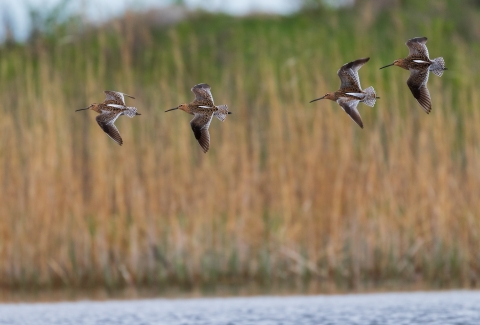
Shorebirds are known for their long-haul migrations between wintering and breeding sites. In North America, shorebirds migrate between arctic nesting grounds and Central and South America. As M.A. Colwell noted in 2010, long distance migration requires large energy reserves, so shorebirds spend a large portion of their time foraging on soft-bodied invertebrates such as worms, insects, and small crustaceans.
Along their migration routes from mid-July through early-October, shorebirds use a variety of habitats including sandy beaches, intertidal mudflats, freshwater wetlands, grasslands, flooded agricultural lands, rocky coastlines, and plowed fields.
- Least sandpiper Calidris minutilla | Charadriiformes
- Killdeer Charadrius vociferus | Charadriiformes
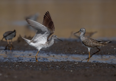
- Lesser yellowlegs Tringa flavipes | Charadriiformes
- Semipalmated sandpiper Calidris pusilla
- Short-billed dowitcher Limnodromus griseus | Charadriiformes
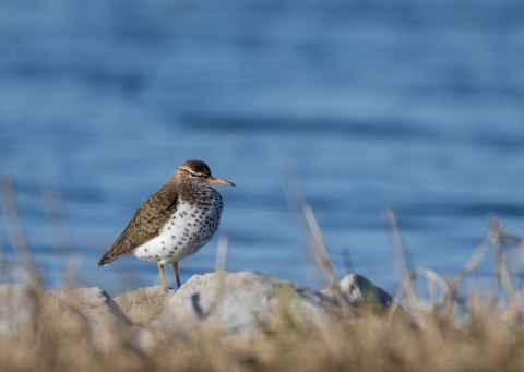
- Spotted sandpiper Actitis macularius | Charadriiformes
Observed species
Out of 25 total shorebird species observed, 14 had observation counts rendering them a significant species to monitor during the growing season drawdown. The abundance and diversity of species reflects the ecological importance of mudflat exposure and soil regeneration. The shorebird species counts in East Pool and from other points of observation across the refuge for the 14 species are listed in the table below.
| Species name | East Pool | Other |
| American golden-plover | 0 | 8 |
| Baird's sandpiper | 1 | 73 |
| Greater yellowlegs | 41 | 27 |
| Killdeer | 817 | 871 |
| Least sandpiper | 2266 | 945 |
| Lesser yellowlegs | 491 | 457 |
| Pectoral sandpiper | 155 | 87 |
| Semipalmated plover | 295 | 25 |
| Semipalmated sandpiper | 431 | 109 |
| Short-billed dowitcher | 82 | 44 |
| Solitary sandpiper | 11 | 20 |
| Spotted sandpiper | 54 | 686 |
| Stilt sandpiper | 199 | 61 |
| Wilson's snipe | 30 | 62 |
| Grand total | 4993 | 3355 |
Project outlook
Following the full drawdown cycle, refuge biologists will collaborate with the U.S. Army Corps of Engineers on monitoring efforts to assess shorebird and vegetation responses to fine-tune water level management to maximize habitat quality, while not compromising on floodwater storage.
The primary purpose of the Highway 75 Dam is flood control. Therefore, if a heavy rainfall event occurs where the Highway 75 Dam cannot evacuate the inflow quickly enough to maintain the drawdown, then water would be held in East Pool. The drawdown would start over once water could be released, potentially not again until the following year.
Highway 75 drawdown timing
Because the primary purpose of the Highway 75 Dam is flood risk management along the Minnesota River, a full drawdown remains dependent upon regional weather patterns. Drier conditions are more favorable to a drawdown. A dry spring followed by a wet summer could also cancel drawdown plans for that year, at which point another attempt may be made the following year.

Potential dredging
The Highway 75 Dam has a fixed minimum elevation, which limits how far water levels can be lowered. A channel dug across the pool should allow water to move north into the Minnesota River, where it passes through a water control structure that can further reduce water levels below the dam’s fixed elevation. However, in the 50 years since its construction, this channel has filled with sediment and may no longer serve its intended use. In this event, the channel may need to be dredged to restore its function and to facilitate a complete drawdown of East Pool.
The big picture
Big Stone National Wildlife Refuge is approximately 7 river miles upstream of the Marsh Lake Habitat Enhancement Project, which is seeing success from similar drawdown efforts. Their drawdowns have improved the amount of emergent and submergent vegetation. While in the drawdown phase, the newly exposed mudflats have attracted thousands of shorebirds. The combined efforts of the Highway 75 and Marsh Lake projects will increase the number of birds in the upper Minnesota River corridor over time and increase or enhance recreational uses of the area.
Salt Lake birding
Every spring since 1977, more than 100 birdwatchers gather near Marietta, Minnesota, to enjoy a rare habitat feature for the state, known as Salt Lake. Salt Lake, being high in salt, attracts unique species of birds as well as a vast abundance and overall diversity. Being only 20 miles from Big Stone National Wildlife Refuge, birdwatchers make the most of their time by also exploring the refuge in the same trip. The Highway 75 habitat enhancement project is sure to attract more birdwatchers to the refuge due to its ties to other hotspots. Additionally, the auto tour within the refuge sees nearly 100 visitors per day. A similar auto tour exists along the top of the Highway 75 Dam, and habitat improvements should draw in the same number of visitors, if not more, once the habitat is enhanced.
Partnership
This collaborative project is part of the Sustainable Rivers Program, a nation-wide initiative and partnership between the U.S. Army Corps of Engineers and The Nature Conservancy, that investigates various watersheds and is focused on enhancing the environment through coordinated U.S. Army Corps of Engineers-managed reservoir operations modifications. The program began in 2002, as an effort to find more sustainable ways to manage river infrastructure to maximize benefits for people and nature. The focus of the program is determining unique flow requirements for rivers and then creating operating plans for dams that achieve beneficial environmental flows to revive and sustain critical ecological functions and habitat for species.