


Aerial Seabird Surveys
Every summer the Oregon Coast National Wildlife Refuge Complex conducts aerial surveys of breeding birds at seabird colonies along the Oregon Coast. This project provides valuable data to both Migratory Bird and National Wildlife Refuge programs within the U.S. Fish and Wildlife Service, as both seek to understand and manage the many seabird species that are an integral part of the Pacific Northwest coast.
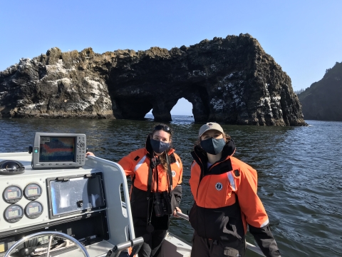
May and June are when Common Murres, which spend most of their lives at sea, return to lay a single egg. By August, the parents and young murres are headed back to their lives at sea. Each year, U.S. Fish and Wildlife Service (Service) biologists fly the entire coast of Oregon, photographing seabird colonies of common murres and cormorants from a helicopter. Shawn Stephensen, a biologist with the U.S. Fish and Wildlife Service, spends a couple of days a year leaning out of a helicopter, taking pictures of the birds. The free-standing rocks and islands provide seabirds protection from land predators like skunks and coyotes; however, raccoons can still swim out to islands to prey on nesting seabirds! The islands are close to food sources for murres, which dive up to 500 feet in search of small fishes like sandlance, herring, smelt and juvenile rockfish. Pelagic, Brandt’s, and Double-crested Cormorants also nest on the rocks, reefs and islands. The cormorants are also piscivorous (fish-eaters) and dive to capture their prey. The isolated colonies are good for the seabirds but makes counting them only possible from the air.
When he’s taking pictures, Stephensen knows the days will be long. He spends 10-12 hours in a helicopter with its doors removed, a four-point harness holding him safely in place and a digital camera firmly in hand (and strapped around his neck!). Some days are really warm, and other days the cold wind off the ocean can leave his fingers numb as he holds the camera up to his face for hours on end. Despite the safety helmet he wears, the loud noise of the helicopter blades seems relentless. Stephensen is not alone, though; the pilot and another photographer are there with him, all concentrating on the task at hand.
The days after the helicopter ride are even longer. Stephensen will be responsible for cataloging the photos and matching the photographs with each seabird colony on the coast. Each colony has a specific identification number. Some of the smallest surface-nesting colonies only have 2-4 birds, while the largest, at Yaquina Head, may have up to 90,000 murres. The two photographers take pictures from different angles; the person in front takes close ups and the person in the back takes distance shots. This makes it easier to catalog and reconcile the pictures. "We spend two days in the helicopter," Stephensen said, "and at the end of them, we have between 5,000-6,000 photos of the seabird colonies along the Oregon Coast." Fortunately, they use the GPS (Global Positioning System) readings from the helicopter flight, which tracks latitude and longitude every 3 seconds. Later, they are able to match the time stamp from each photo with the helicopter’s flight path.
“Once we have all the photos assigned to the right colony, we pick the best photo to count. Sometimes we stitch the photos together to make sure the whole colony is covered.” said Shawn. Then he uploads the files using GIS (Geographic Information System) software, which displays the photo on the computer screen. Using his mouse, he marks each bird with a dot, and then the computer counts the dots. Because he’s counting different species, Stephensen uses yellow dots for murres and bigger, green ones for Brandt’s Cormorants. It requires a lot of patience to make sure each bird is dotted, and often he takes breaks to let his eyes rest. Sometimes, Stephensen even dreams about counting birds. Every murre counts!
In the past, Shawn used slide film and would have to load a roll of film into the camera after every 36 pictures. Once the slides were developed he would project them onto a wall and hand-paint the dots on the birds, turn off the slides, then count all the dots by hand. This all changed in 2009 with improving technology. Digital cameras and computers have made counting seabirds much faster and more accurate. He can take up to 1,500 photos before replacing the memory card in the camera, and the computer can count the dots much faster than he can.
From these photographs, biologists count the surface-nesting birds and estimate the breeding populations of the birds, all of which nest on the flat or sloping surfaces of these free-standing rocks and islands. This data is entered into the Oregon Seabird Colony Database, which helps identify the current distribution and abundance of Common Murres and cormorants at colonies on the Oregon coast. These counts are part of a large historical data set that goes back to the early 20th century. This means there's more than 110 years of information about seabirds in Oregon, although it wasn’t until the 1980s that we developed the survey methods still used today. As a comparison, in Alaska, there are seabird counts dating from the 1880s.
This information helps biologists understand trends and changes to seabird populations over time, which in turn helps us understand the marine environment at large. Seabirds are very sensitive to changes in food supply and sea temperature, and can be easier to study than other oceanic species. This makes them a good indicator species for marine health. The Service can use this information to assess the effects of disruptions such as climate change climate change
Climate change includes both global warming driven by human-induced emissions of greenhouse gases and the resulting large-scale shifts in weather patterns. Though there have been previous periods of climatic change, since the mid-20th century humans have had an unprecedented impact on Earth's climate system and caused change on a global scale.
Learn more about climate change , lights, noise and other disturbances on Oregon’s seabirds. The distribution of nesting Common Murres has changed along the Oregon Coast in recent years—increasing in some locations and decreasing in others—and these annual surveys have helped to track these changes.
Stephensen says that his information also feeds into an international database. “We send the data to a larger database from Oregon, Alaska, Russia and Japan and see it at seabirds.net so that we can see what’s happening to seabirds around the Pacific. To have it all in one location is a great resource for everybody.”
Are you interested in seeing and counting the birds for yourself? The colonies at Yaquina Head, located just north of Newport, are easily observable and a great place to witness the action first hand. An observation deck and spotting scopes provided by the Bureau of Land Management (BLM) are available at Yaquina Head Outstanding Natural Area. BLM manages the headland and USFWS manages the offshore rocks, reefs, and islands and are part of the Oregon Islands National Wildlife Refuge.

