

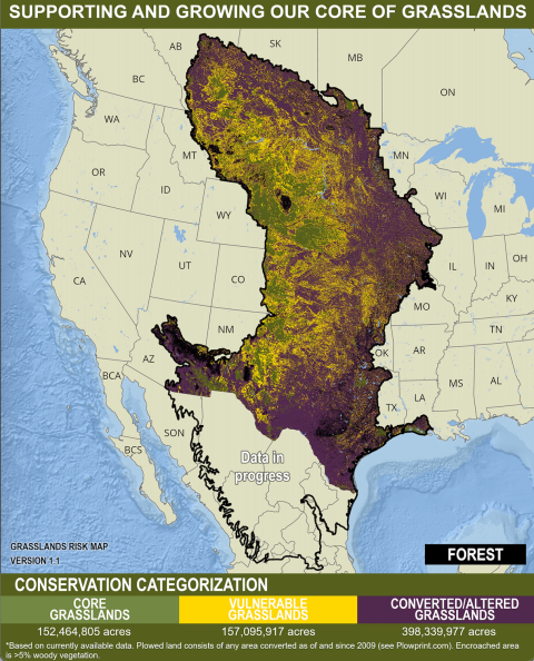
FORT COLLINS, Colo. – The Central Grasslands Roadmap (CGR) partnership is proud to introduce the Central Grasslands Assessment Map. Over the last three years, the U.S. Fish and Wildlife Service (Service) has teamed up with this diverse community of partners from Indigenous Nations, Canada, Mexico, and the United States to think strategically about how to help change the trajectory of our grasslands from degraded and fragmented to thriving, productive lands for people and wildlife. The Assessment Map showcases our Central Grasslands and is guiding voluntary investments in their conservation.
The Central Grasslands Assessment Map can help the Service be an effective partner by guiding where we direct Service resources. This map will serve as a guide for voluntary investments in conservation across this critical landscape.
The Central Grasslands span more than 700 million acres across Indigenous nations, Canada, the United States, and Mexico. Unfortunately, much of this landscape has been fragmented through conversion to row-crop agriculture and the spread of invasive trees and shrubs.
“In the last 10 years alone, the United States has lost more than 50 million acres of grasslands, a staggering statistic that has countless impacts,” said Matt Hogan, U.S. Fish and Wildlife Service Regional Director for the Mountain-Prairie Region. “Grasslands are home to thousands of species, serve as safe corridors for migratory birds and mammals, and provide services that are critical to our way of life – from agriculture and recreation to protecting communities and wildlife from fire, drought, and a changing climate. No matter where we live, we are all dependent on the survival and health of grasslands.”
“The Great Plains is home to some of the last remaining large and intact grasslands in the world, but this biome is the most imperiled and least protected of the world’s major vegetation types,” said Dr. Dirac Twidwell, rangeland ecologist at the University of Nebraska–Lincoln and science adviser to the USDA Natural Resources Conservation Service and it’s Working Lands for Wildlife program. “The Central Grasslands Assessment Map represents an unprecedented collaborative effort to combine the latest science and technology for more strategic conservation action and to conserve the culture, ecosystem services, and unique biodiversity that depend on grasslands.”
Fortunately, it isn’t too late to restore the health of these grasslands. The Service works alongside our partners to leverage our investments, maximize conservation outcomes, and achieve our shared conservation goals. “Together our collaborative conservation efforts can reverse the trend and conserve this vital landscape,” Hogan added.
To address these challenges, the CGR provides a flexible strategic framework. This assessment map is core to implementing this framework. Local partners and community members can use this map to identify opportunities where short- and long-term conservation programs need to take place. This large-scale approach works best when partners combine local priorities, resource concerns, and community will.
This map categorizes three areas of conservation to support and grow our core grasslands. By keeping healthy grasslands intact and “green-side up” (shown in green on the map), these grassland areas can ensure food and water security, provide space for cultural and recreational activities, and safeguard land sovereignty for Indigenous Nations. Voluntary short- and long-term conservation programs and practices are needed to keep these core grasslands intact and support grass-based economies to help rural communities thrive.
Work needs to be done in the yellow areas, which represent lands impacted or threatened by land use changes and the spread of woody vegetation and other annual invasive species invasive species
An invasive species is any plant or animal that has spread or been introduced into a new area where they are, or could, cause harm to the environment, economy, or human, animal, or plant health. Their unwelcome presence can destroy ecosystems and cost millions of dollars.
Learn more about invasive species . Yellow areas are key to protecting, connecting, and growing native grasslands core areas. Every effort should be made to ensure that these areas remain healthy, connected grasslands that benefit both rural communities and wildlife.
Purple indicates areas that need strategic investments that include, but are not limited to, removing invasive woody species, converting cropland on marginal soils back to grassland, and connecting to larger blocks of existing grassland.
Members of the public have also been invited to comment on the U.S. Department of Agriculture’s proposed implementation of Inflation Reduction Act funding. USDA’s Natural Resources Conservation Service will use the investments provided through IRA-funded conservation programs to support farmers and ranchers in adopting and expanding climate-smart activities and systems.
About the Central Grasslands Roadmap
The Central Grasslands Roadmap aims to guide and inform innovative and connected conservation for the benefit of grassland birds, pollinators and mammals, as well as to ensure viable human communities across the landscape of one of North America’s most biogeographically unique areas. The Roadmap community includes a cross-section of leaders and experts that live and work in the Central Grasslands — including producers on working land, Sovereign First Nations and Indigenous Communities, federal, state and provincial agencies, foundations, industry, and nongovernmental organizations including; land trusts, conservation organizations, and academia. For more information: https://www.grasslandsroadmap.org/
Latest Press Releases


