


The U.S. Fish and Wildlife Service in conjunction with the Alabama Department of Conservation and Natural Resources and the Geological Survey of Alabama have selected watersheds and river segments in the five HUC-4 subregions in Alabama to focus conservation activities for managing, protecting, restoring, and recovering populations of rare fishes, mussels, snails, and crayfishes. These Strategic Habitat Units (SHUs) and Strategic River Reach Units (SRRUs) include a substantial part of Alabama’s remaining high-quality rivers and streams and reflect the variety of small stream to large river habitats occupied by these species historically and/or currently.
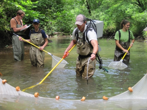
The SHUs were selected based on best available information about the essential habitat components required by these aquatic species including: (1) geomorphically stable stream and river channels; (2) stream flow regimes that support normal behavior, growth, and survival of the animals; (3) acceptable water-quality conditions necessary for normal behavior, growth, and viability of all life stages of the animals; (4) a diversity of channel substrate types, with minimal amounts of fine sediment and filamentous algae; (5) for mussels, the presence of fish hosts with adequate living, foraging, and spawning areas; and (6) few or no competitive or predaceous nonnative species. The SRRUs were selected based on the historical and/or current presence of rare species and include river reaches where species restoration and recovery actions are planned for the future or are already underway.
The purpose of designating SHUs and SRRUs is to facilitate and coordinate watershed management and restoration efforts as well as to focus funding to address habitat and water quality issues. All of the SHUs currently support one or multiple federally listed species and/or critical habitat designated by the U.S. Fish and Wildlife Service.

The partnership created under the SHU Umbrella is known as the Alabama Rivers and Streams Network. The ARSN webpage has information on much of the work being done in the SHU's and provides up to date info on new stories and events taking place across the state. Also follow us on the Alabama Rivers and Streams Network Facebook page.
Clean water for our future - key to a prosperous Alabama
Alabama Rivers and Streams Network SHU Mapper
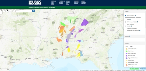
The Alabama Rivers and Streams Network SHU website and database system is a joint project of the Alabama Rivers and Streams Network (ARSN) and the USGS Wetland and Aquatic Research Center with partial funding from the Alabama Department of Transportation. The system serves as a repository for both tabular and geospatial data related to specially-designated watersheds, river segments, and road crossings within Alabama and neighboring states.
Strategic Habitat Units (SHUs) and Strategic River Reach Units (SRRUs) are watersheds and river reaches that in the opinion of aquatic biologists practicing in Alabama support viable and healthy aquatic habitat, populations of imperiled species, and provide good opportunities for their restoration and recovery. SHU-related data is used in facilitating and coordinating watershed management and restoration efforts, cataloguing and improving existing highway infrastructure, and focusing funding to address habitat and water-quality issues.
Geological Survey of Alabama Special Map248-B
Geological Survey of Alabama Special Map248-B displays the locations of the 46 SHUs and 14 SRRUs in Alabama and adjoining states. Colored polygons represent the watershed area of each SHU, with the exception of the MobileTensaw River Delta SHU, which drains the entire Mobile River basin. Each SRRU represents the corridor of a major river or large stream. Each SHU and SRRU is also part of a larger National Hydrography Dataset (NHD) Hydrologic Unit (HU)-4 subregion. The index map displays the location of each HU-4 subregion.
