
Archived Documents for CBRS Remapping Project
This collection contains materials related to the proposed and final recommended boundaries for the comprehensive remapping project of Coastal Barrier Resources System (CBRS) units P31/P31P in Bay County, Florida.
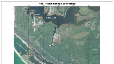
Overview of the Remapping Project
The U.S. Fish and Wildlife Service (Service) prepared three draft revised maps dated May 16, 2016, for three existing and two proposed new CBRS units in Bay County, Florida: St. Andrew Complex P31/P31P.
Following a 45-day public review period that ended in August 2016, the Service submitted and transmitted final recommended maps to Congress dated October 7, 2016.
The revised final recommended maps were adopted by Congress through Public Law 115-358 on December 21, 2018.
Accessing Archived Materials
To the left, you will find:
- Final Recommended Map(s): The 2016 final recommended map for the CBRS units.
- Public Comments Summary: A summary of public comments received during the review period, along with the Service's responses.
- Summary of Changes: An overview of the final recommended changes made to the units.
- Proposed Map(s): An archive of the earlier proposed boundaries and summary of proposed changes that were made available for public review.
Other Related Information
- Federal Register notice announcing availability of draft maps and request for comments (July 7, 2016)
- Service Testimony (February 27, 2018)
Media Usage Rights/License
Public Domain
Program
