
Archived Documents for CBRS Remapping Project
This collection contains materials related to the proposed, final recommended, and revised final recommended boundaries for the comprehensive remapping project of Coastal Barrier Resources System (CBRS) units P30/P30P in Gulf County, Florida.
Overview of the Remapping Project
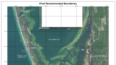
The U.S. Fish and Wildlife Service (Service) prepared two draft revised maps dated October 7, 2016, for two existing CBRS units in Gulf County, Florida: Cape San Blas Unit P30/P30P.
Following a 45-day public review period that ended in August 2016, the Service submitted and transmitted final recommended maps to Congress dated October 7, 2016. The Service subsequently produced slightly revised versions of these maps dated December 19, 2018. The 2018 final recommended maps are identical to the 2016 final recommended maps except that the newer maps have updated aerial imagery and do not include the addition of a 3-acre developed area located at the edge of the unit and along State Route 30-A.
The revised final recommended maps were adopted by Congress through Public Law 116-9 on March 12, 2019.
Accessing Archived Materials
To the left, you will find:
- Revised Final Recommended Map(s): The 2018 revised final recommended map for the CBRS units.
- Final Recommended Map(s): The 2016 final recommended map for the CBRS units.
- Summary of Changes: An overview of the final recommended changes made to the units.
- Proposed Map(s): An archive of the earlier proposed boundaries and summary of proposed changes that were made available for public review.
Other Related Information
- Federal Register notice announcing availability of draft maps and request for comments (July 7, 2016)
- Public Comments Summary: A summary of public comments received during the review period, along with the Service's responses.
Media Usage Rights/License
Public Domain
Program

Ecosystem