Land Protection Planning
The U.S. Fish and Wildlife Service (Service) is proposing to advance conservation in the Coastal Bend region of Texas through expansion of the Aransas National Wildlife Refuge (refuge). The refuge currently includes land in Aransas, Calhoun, and Refugio Counties. The expansion could include land in Jackson, Matagorda, San Patricio, and Victoria Counties. As part of the proposal, the Service will prepare a Land Protection Plan for the refuge, which will position the conservation community to better address the current and future needs of wildlife and wildlife habitat in the Coastal Bend region as opportunities for future conservation arise.
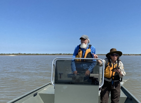
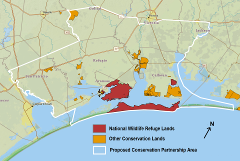
The Service has worked with conservation partners to identify a conservation strategy centered on maintaining the long-term viability of the existing refuge and the species that depend on it. The strategy focuses on key coastal prairie and marsh habitat that supports whooping crane and mottled duck. Many other species will benefit from protection of the same habitat, including endangered species like black rail as well as species that could become endangered if conservation action is not taken. A draft expansion boundary has been identified, within which the Service and its conservation partners could reach voluntary agreements with willing landowners to protect and restore priority wildlife habitat. The area inside the expansion boundary is called the Conservation Partnership Area.
What to Expect
The Service’s Land Protection Planning process adheres to the following principles:
- Decision making on rigorous science and measurable conservation outcomes
- Robust coordination with stakeholders including state and local governments, private landowners, and nonprofit groups
Why Are We Proposing to Expand?
The Service is responding to the best available science and local conservation partners who have expressed interest in expanding the Aransas National Wildlife Refuge. The proposed expansion addresses changes to the landscape that may be caused by energy development, habitat fragmentation, sea level rise and shrinking wetland habitat.
Once a Land Protection Plan is finalized, the Service may begin to:
- Work with conservation partners and interested landowners to obtain conservation easements or fee title interest in lands in the Conservation Partnership Area
- Plan restoration and conservation projects on lands in the Conservation Partnership Area
Participation in Land Protection Plan programs will be voluntary. Conservation easements, fee title sales, or other voluntary conservation programs will only move forward with willing landowners, sellers, and partners.
What Does the Expansion Process Look Like?

The expansion process begins with a science-based review of the species and habitat types that occur in the Coastal Bend region. Public input is an important next step in the planning process that helps the Service decide where and how to expand the refuge boundary in the future. After a scoping period and conversations with stakeholders, the Service will develop a draft Land Protection Plan for the refuge that outlines the proposed expansion boundary.
The draft plan will be released for public comment and be subject to environmental review before the Landscape Protection Plan is finalized. See the map below for the draft boundary of the proposed Conservation Partnership Area.
What are the Benefits?
The long-term benefits of the proposed Land Protection Plan include greater habitat connectivity and protection for:
- Whooping Crane
- Mottled Duck
- Black Rail
- Piping Plover
- Northern Aplomado Falcon
- Reddish Egret
- Bobwhite Quail
- Migratory songbirds
- Other game and non-game fish and wildlife
The Service also expects the following benefits to the Coastal Bend Region:
- Increased public access to outdoor recreation (hunting, fishing, birdwatching, hiking, photography, etc.) on public land
- Increased revenue to local businesses and governments from tourism and recreation spending
- Protection of the region’s rural ranching and farming heritage
- Buffering communities from coastal storms and sea level rise
- Increased grant funding opportunities for local conservation groups
Frequently Asked Questions
If I own land in the Conservation Partnership Area, would I ever be forced to sell?
No. Expansion boundaries are not refuge boundaries. All habitat restoration and property acquisition by the Service would be on a voluntary basis (willing seller only), and only lands in which the Service acquires a property interest would become part of a refuge.
Could my property ever be condemned?
No. The Service has a long-standing policy to acquire land for refuges only from people interested in selling to us. The Service will not use eminent domain or condemnation to acquire lands. As the opportunity arises, the Service will acquire land from interested landowners within the Conservation Partnership Area who wish to sell or place easements on their land for the conservation of wildlife.
Will my rights as a property owner be infringed as a result of the refuge expanding its boundaries?
No. Being included within an expansion boundary does not give the Service any more authority over private or public lands. Landowners retain all the rights, privileges, and responsibilities of private land ownership.
When the Service acquires property, what will the impact be on local property tax revenue?
The Service does not pay property taxes on land it owns. When the Service acquires fee-title interest in property, the local government becomes eligible for a program called Refuge Revenue Sharing, which requires the Service to make payments to local governments to offset lost tax revenue. When the Service acquires a conservation easement conservation easement
A conservation easement is a voluntary legal agreement between a landowner and a government agency or qualified conservation organization that restricts the type and amount of development that may take place on a property in the future. Conservation easements aim to protect habitat for birds, fish and other wildlife by limiting residential, industrial or commercial development. Contracts may prohibit alteration of the natural topography, conversion of native grassland to cropland, drainage of wetland and establishment of game farms. Easement land remains in private ownership.
Learn more about conservation easement over property, the land remains on the tax rolls.
How much of the land inside the proposed Conservation Partnership Area does the Service intend to acquire?
The Service will acquire fee title or conservation easements on only a small proportion of the land within the boundary. The Land Protection Plan will set a fixed limit on the number of acres that the Service can acquire. Within that limit, the Service will seek to acquire specific properties that have the best habitat value and are best suited for management by the Service. The reason for the larger area within the expansion boundary is to provide flexibility. Some owners of land with high habitat value will choose not to work with the Service, and that will require the Service to seek alternatives. In the unlikely event that no landowners elect to sell to the Service, the Service will not acquire any additional property.
Other public agencies with conservation purposes, like the Texas Parks and Wildlife Department and the USDA Natural Resources Conservation Service, own land and conservation easements within the expansion area and are likely to add to their holdings in coming years. Private conservation organizations, typically considered to be “land trusts,” also acquire land and easements from time to time. This will provide other options to landowners who are interested in protecting or restoring their property.
When will the Service acquire this property?
It will likely require a year or more to complete the land protection planning process and give the Service authority to proceed. Then the Service’s ability to implement the plan by acquiring fee-title and conservation easement interests will be limited by available funding. It would likely require decades for the Service to fully achieve its land protection objectives.
Is this conservation proposal part of the Biden Administration’s “30 x 30” or “America the Beautiful” initiative?
Protection of wildlife habitat within the Coastal Bend region has a long history. The Aransas National Wildlife Refuge was established in 1937 to serve as “a refuge and breeding ground for migratory birds and other wildlife.” For several years, the Service has been studying the land use and wildlife population trends in the Coastal Bend region in anticipation of the need to expand holdings of the refuge.
Is this conservation proposal being driven by a recovery plan for the whooping crane?
Protection of habitat for the whooping crane will be an important consideration. The crane is currently on the federal endangered species list, but its population has been trending upward. As the wintering population grows, the cranes are occupying additional habitat along the coast, much of which is currently not protected. The Coastal Bend region also provides important habitat for other endangered species, like black rail and piping plover, as well as species that are in decline and could become listed as endangered if conservation action is not taken.
I am a landowner; how will a conservation easement or fee-title sale benefit me?
Conservation easements provide permanent protection to natural resources while retaining private landownership. The landowner retains ownership of the land but sells certain rights identified and agreed upon by both parties. The value a landowner may expect to receive for an easement is dependent on the number of rights the landowner chooses to sell. Because ownership of the land remains with the individual, the property remains on the local tax rolls. In most cases, landowners do not grant access for public use under a conservation easement. The Service pays fair market value for property and any rights purchased.
Fee-simple acquisition involves an interested landowner agreeing to sell to the Service most or all the rights
to their property. There is a total transfer of property with the formal conveyance of a title to the federal government. In some instances, certain rights such as mineral rights or use reservations can be negotiated at the time the property is transferred in ownership. The Service pays fair market value for property and any rights purchased.
To learn more:
Contact Refuge Manager, Joe Saenz, at joe_saenz@fws.gov
Email with questions or comments to R2_plancomments@fws.gov
Download a printable PDF version of the brochure.
A similar land protection planning effort is underway for Big Boggy National Wildlife Refuge.