
Visit Us
The Visitor Center offers interactive exhibits, including three short movie presentations featuring the wildlife and history of the area. A short interpreted nature trail wanders through the woods behind the center. In addition, you can find information and resources for visiting any of the refuges and fish hatchery in Coastal North Carolina--chat with our volunteers to find out what's been seen recently, pick up maps and driving directions, and learn about guided programs and events.
Activities
Explore the Visitor Center Exhibits, take a hike on the trails, or spend some time shopping in the Wild Things Gift Shop, operated by the Coastal Wildlife Refuge Society. All proceeds benefit local refuges.
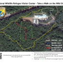
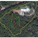
A series of short, but beautiful nature trails wrap around the National Wildlife Refuges Visitor Center. These range from 1/8 mile to almost .75 mile in length.
Trails
We offer 35 acres of relatively wild land to explore, including 4 walking trails ranging from 0.12 to 0.66 mile each.
Related Documents
The Visitor Center sits on 35 acres of wild land to explore, including 4 walking trails. Many types of plants, birds, small mammals, and reptiles and amphibians are found on the grounds. In front of the Visitor Center is a pollinator garden filled with native plants that support many species of native pollinators and other wildlife.
The Georeferenced Trail Map can be loaded into a mapping application such as Avenza on a phone or tablet. Open the file on your mobile device, open in Avenza, and the map will show your location on the trail system.
Other Facilities in the Complex
The Gateway Visitor Center serves as an introduction to the Coastal North Carolina National Wildlife Refuge Complex, as well as two other refuges and a national fish hatchery in the area: Great Dismal Swamp NWR, Back Bay National Wildlife Refuge, and Edenton National Fish Hatchery. A National Wildlife Refuge Complex is an administrative grouping of two or more refuges, wildlife management areas or other refuge conservation areas that are primarily managed from a central office location. Refuges are grouped into a complex structure because they occur in a similar ecological region, such as a watershed or specific habitat type, and have a related purpose and management needs.
There are 9 national wildlife refuges in the Coastal North Carolina National Wildlife Refuges Complex. The Project Leader for the Complex supervises the Refuge Managers who are responsible for managing these refuges. However, there are five distinct and separate administrative offices. Alligator River and Pea Island National Wildlife Refuges are administered from the Alligator River National Wildlife Refuge Headquarters in Manteo, NC. An administrative office at the Mackay Island National Wildlife Refuge Headquarters in Knotts Island, NC manages both Mackay Island and Currituck National Wildlife Refuges. An office at Mattamuskeet National Wildlife Refuge administers Mattamuskeet, Swanquarter, and Cedar Island National Wildlife Refuges. Pocosin Lakes National Wildlife Refuge, Roanoke River National Wildlife Refuge, Great Dismal Swamp National Wildlife Refuge, Back Bay National Wildlife Refuge, and Edenton National Fish Hatchery each have separate administrative offices.
All of the Coastal North Carolina National Wildlife Refuges, Great Dismal Swamp National Wildlife Refuge, Back Bay National Wildlife Refuge, and Edenton National Fish Hatchery are open to public visits for nature-based recreational enjoyment. Priority public uses are hunting, fishing, wildlife observation, wildlife photography, environmental education, and interpretation.


Locations
Conservation Way (the entrance road to the National Wildlife Refuges Visitor Center) is located on the southeast side of US Highway 64 Business, just southwest of the entrance to Ft. Raleigh National Historic Site, The Lost Colony, and the Elizabethan Gardens.
Directions From North (Norfolk and Currituck Area):
Take US 168 south. US 168 becomes US 158 about 18 miles south of the NC/VA line. Continue on US 158 for about 23 miles. At this point, you will cross the Wright Memorial Bridge across the Currituck Sound. After the bridge, continue on US 158 through Kitty Hawk, Kill Devil Hills, and Nags Head. At the south end of Nags Head, US 158 will transition to US 64 west. Continue on US 64 across one small and one large bridge onto Roanoke Island. Take a right at the second light to head north on Highway 64 Business into Manteo. After about 4.5 miles, turn left at the sign for the National Wildlife Refuges Visitor Center.
Directions From West (Raleigh Area):
Take US 64 East from Raleigh. Travel east on US 64 for approximately 3 hours. Approximately 12 miles east of the town of Columbia, US 64 will cross the Alligator River and pass through Alligator River NWR. After about 13.5 miles, cross the Virginia Dare Memorial Bridge onto Roanoke Island. Turn left at the first traffic light to head north on Highway 64 Business into Manteo. After about 4.5 miles, turn left at the sign for the National Wildlife Refuges Visitor Center.
Directions From South (Hatteras Area):
Travel north on Highway 12 through Frisco, Buxton, Avon, Waves, Salvo and Rodanthe, passing through Pea Island NWR, to the intersection with Highway 64 west at Whalebone Junction. Turn left onto Highway 64 West (signs for Manteo). Cross one small and one large bridge onto Roanoke Island. Take a right at the second light to head north on Highway 64 Business into Manteo. After about 4.5 miles, turn left at the sign for the National Wildlife Refuges Visitor Center.