

Location
States
ArizonaIntroduction
Cuenca los Ojos (CLO) is a non-profit 501c3 organization with the mission of preserving land and restoring watersheds in the Sky Island ecoregion of the U.S. and Mexico--a region of high biodiversity which is attributed to its varied landscape with isolated mountain ranges surrounded by expanses of deserts and grasslands. CLO’s ranches are situated within a broader network of protected lands and serve to connect these lands as corridors for wildlife species and watershed health.
Key Issues Addressed
The borderlands of Arizona and Sonora have experienced widespread degradation as a result of changing land use patterns, historic overgrazing, and altered fire regimes. This degradation has had lasting impacts on ecosystems and people. Increased habitat fragmentation, species loss, and accelerated erosion have led to landscapes that are less productive and less resilient to disturbance. For many private landowners, healthy working lands are essential for their livelihood. Conservation-minded stewardship of private lands can support this livelihood and benefit the broader landscape. CLO has installed thousands of erosion control structures to mitigate erosion and restore resiliency to their lands.
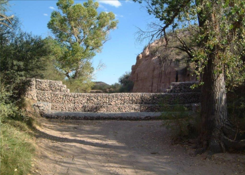
Loss of vegetation in uplands resulting from unsustainable land use can lead to accelerated erosion with soil loss, and rapid runoff during rain events that is not absorbed into the ground. High-intensity flows concentrate in ephemeral washes, incising channels and transporting heavy sediment loads downstream. As channels become further incised, less water is retained on the landscape. When rainfall does not quickly leave watersheds as surface runoff, it has the opportunity to infiltrate, providing soil moisture that supports vegetation and wildlife. One potential solution that can slow runoff and improve vegetation cover is to install rock erosion control structures, such as one-rock dams in channels or on hillslopes, and check dams (usually ~3 foot high loose rock structures set into channels) or rock gabions (rocks wrapped in a wire cage) in channels.
Project Goals
- Reduce the effects of accelerated erosion by installing erosion control structures on hillsides and stream channels
- Raise incised channel beds and promote infiltration by accumulating sediment behind erosion control structures
- Share techniques through workshops and presentations
Project Highlights
Sharing through Workshops: Cuenca los Ojos hosts workshops in the US and Mexico where participants can learn how to build trincheras, gabions, and other erosion control structures.
- Collaborative Conservation: CLO works across a broad landscape in both the US and Mexico and collaborates with scientists, federal agencies, non-governmental organizations, and neighboring landowners, to affect large-scale conservation that could not be done in isolation. Partners include: The Northern Jaguar Project (MX), Sky Island Alliance (US) , Borderlands Restoration (US) and Fundó Mexicano para la Conservación de la Naturaleza (MX), and federal agencies in the US and Mexico that help to fund restoration work.
- Top-Down Restoration: Starting from the top of the watershed is an effective way to reduce erosion by slowing surface flow that gains energy as it travels downhill. To do so, CLO installed small, loose rock dams called trincheras where hillsides were noticeably eroding with evidence of vegetation loss and small channel formation. The structures were placed close together, with the top of one structure on the same level as the bottom of the structure above it, nearly overlapping like steps. Thousands of structures were installed over a 20-year period.
- Tackling Streambed Erosion: After seeing success in reducing hillside erosion with rock structures, the next step was to mitigate erosion in ephemeral washes. Washes can experience intense runoff events with high-volume flows that further incise the channel. For this reason, structures in washes were carefully constructed to withstand intense flows. Some general guidelines for constructing strong in-stream erosion control structures include:
- Fit the rocks snugly against one another so that water will not lift and displace the rocks, but force the rocks more firmly into the pile.
- For gabions, tie-in the sides of the structure to a tree or large rock. In large streambeds with few rocks or trees, it may be necessary to dig into the banks on either side in order to secure the wire baskets.
- Place a gabion so that the height of the downstream basket lines up with the bottom of the gabion above.
- Large-Scale Structures: CLO installed over 50 gabions (large wire baskets filled with rocks) in ephemeral streams in Mexico where channels were deeply incised (10 meters deep or more). Gabions allow water to pass through the channel more slowly, reducing the force of flow during flood events. This results in sediments being deposited around the gabions, which gradually raises the streambed.
Lessons Learned
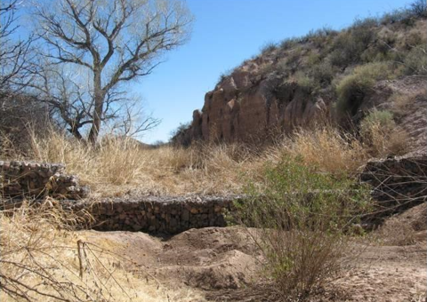
- After 20 years of installing and maintaining erosion control structures, changes in the landscape were obvious--the hillside retained moisture with pools of water present, even in dry months; in washes, sediment deposited around the structures caused streambeds to rise (an 8m deep channel rose to 2m); vegetation grew more densely; wildlife benefited from the increase in surface water; and in Mexico, a once dry stream is now perennially flowing for 8 miles. Restoring habitat has been key to bringing back native wildlife populations such as Coues deers, black bears, and Gould’s turkeys.
- In-channel erosion control structures require maintenance, especially during monsoon season. They must be monitored and modified to withstand heavy rainfall events. When structures “blow out” after intense rainfall, it is necessary to assess what caused the structures to fail and to rebuild them stronger than before. Trincheras on hillsides require minimal maintenance and generally do not need to be replaced or rebuilt.
- Over time, the increased sediment and moisture retention near erosion control structures creates conditions where vegetation can establish and thrive. The roots and canopy of perennial plants help stabilize hillsides and streambanks, eventually removing the need for continued maintenance and creating a self-sustaining ecosystem. For example, when a 500-year flood event in September 2014 caused some gabions to wash out near the San Bernardino National Wildlife Refuge, vegetation that had established behind the gabions helped stabilize the channel and prevent further erosion.
- CLO has partnered with researchers from the U.S. Geological Survey to conduct several research projects examining the effects of erosion control structures on hydrologic processes and vegetation response. In general, results have shown that, even after 30 years, the structures were still functional, and restored watersheds demonstrated increased water retention and increased flow volumes overall compared to untreated watersheds. Researchers documented water yields 28% higher in restored watersheds with erosion control structures compared to an untreated watershed near El Coronado Ranch, a CLO ranch, in the Chiricahua mountains of Arizona.
- Even when structures such as gabions are damaged by heavy floods, they still provide some resistance to flows and retain more sediment and moisture than untreated channels.
Next Steps
- Continue using CLO’s work as an example by hosting workshops and teaching restoration techniques
- Continue installing and maintaining erosion control structures
- Continue to work with researchers to investigate the effects of restoration
Funding Partners
- Many dedicated individuals, non-governmental organizations, and public agencies in the United States and Mexico have collaborated with CLO and provided in-kind contributions.
Resources
- Cuenca los Ojos Website
- Video by Laura Nolier: Cuenca los Ojos-Story of the Founder, Valer Clark
- Barry, T. (2014). “Transborder Drylands Restoration: Vision and Reality After Three Decades of Innovative Partnerships on the U.S.-Mexico Border.” S.A.P.I.EN.S. Surveys and Perspectives Integrating Environment and Society 7:2.
- USGS Chiricahua Mountains Research Webpage
- USGS San Bernadino Wetlands Restoration Webpage
- Norman, L. M., et al. (2015). “Hydrologic Response of Streams Restored with Check Dams in the Chiricahua Mountains, Arizona.” River Research and Applications 32(4): 519–27.
- Norman, L. M., et al. (2014). “Remote sensing analysis of riparian vegetation response to desert marsh restoration in the Mexican Highlands.” Ecological Engineering 70: 241–254.
- Wilson, N. R., & Norman, L. M. (2018). “Analysis of vegetation recovery surrounding a restored wetland using the normalized difference infrared index (NDII) and normalized difference vegetation index (NDVI).”International Journal of Remote Sensing 39(10): 3243–3274.
- Norman, L. M., et al. (2016). “Hydrologic Response of Streams Restored with Check Dams in the Chiricahua Mountains, Arizona.” River Research and Applications32(4): 519–527.
- Norman, L. M., & Niraula, R. (2016). “Model analysis of check dam impacts on long-term sediment and water budgets in Southeast Arizona, USA.” Ecohydrology and Hydrobiology16(3): 125–137.
- Norman, L. M., et al. (2017). “Quantifying geomorphic change at ephemeral stream restoration sites using a coupled-model approach.” Geomorphology283: 1–16.
- Callegary, J. B., et al. (2021). “Preliminary Assessment of Carbon and Nitrogen Sequestration Potential of Wildfire-Derived Sediments Stored by Erosion Control Structures in Forest Ecosystems, Southwest USA.” Air, Soil and Water Research14.
Contact
- Valer Clark, Founder, Cuenca los Ojos: vclark@cuencalosojos.org
Case Study Lead Author
- Ashlee Simpson, CART Graduate Research Assistant, University of Arizona
Suggested Citation
Simpson, A. C. (2022). “Cuenca los Ojos: Three Decades of Restoring Water Flows on Private Land in the U.S. and Mexico.” CART. Retrieved from https://www.fws.gov/project/restoring-water-flows-private-land.
