Cape May NWR Doe-Buck Boundary Project Map Nov 2023.pdf

Document - application/pdf
Cape May NWR Doe-Buck Boundary Project Map Nov 2023.pdf

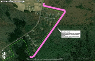
A map depicting a planned ~1.1 miles long and 100-foot-wide fuel break on Cape May NWR.

Attachments
Type of document
Map
Facility
A beach peninsula on an overcast day, with dozens of fishermen in the water.
Welcome! Cape May NWR is located throughout the tip of South New Jersey and along the Atlantic Flyway. Encompassing pristine beach, bayshore, saltmarsh, and upland forest habitats it is world famous for its spectacular migratory bird populations as well as become a crucial area for the...
Media Usage Rights/License
Public Domain