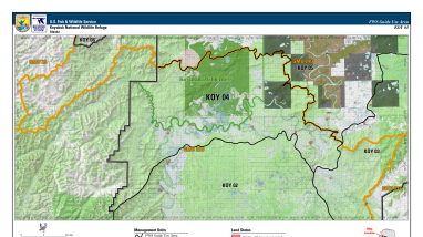
Koyukuk Refuge lies within the extensive floodplain of the Koyukuk River of interior Alaska, about 270 miles west of Fairbanks and contains a unique geological feature: the Nogahabara Sand Dunes. The refuge's rich wetlands combine with lowland boreal forests of spruce, birch and aspen to support a...
The U.S. Fish and Wildlife Service manages an unparalleled network of public lands and waters called the National Wildlife Refuge System. With more than 570 refuges spanning the country, this system protects iconic species and provides some of the best wildlife viewing opportunities on Earth.