Record of Decision
The U.S. Fish and Wildlife Service (USFWS) announces that the Record of Decision (ROD) for the Tijuana Estuary Tidal Restoration Program II Phase I (TETRP II Phase I) Final Environmental Impact Statement has been issued. To review the ROD, go to: https://trnerr.org/about/public-notices/.
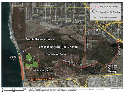
The ROD, which was prepared in accordance with 40 CFR § 1505.2, documents the USFWS decision and rationale for selecting Alternative 2, as described in the TETRP II Phase I Final Environmental Impact Statement/Environmental Impact Report (EIS/EIR), for implementation. Under Alternative 2, approximately 68 acres of coastal wetlands and 15 acres of native transitional and upland habitat will be restored within the Tijuana Estuary (Figure 1). The restoration site is located within southwestern San Diego County, California and is included within the boundaries of the Tijuana River National Estuarine Research Reserve. The project represents a partnership between the USFWS and the California Department of Parks and Recreation, with the northern portion of the restoration site located within the Tijuana Slough National Wildlife Refuge and the southern portion located within Border Field State Park. The U.S. Army Corps of Engineers participated in this process as a Cooperating Agency.

This is a detailed restoration plan for Alternative 2, the alternative selected for implementation. An area of restored low marsh habitat, surrounded by areas of mid to high marsh to the north and south of the existing Model Marsh will be restored. The restored area will be connected to the South Beach Slough. Smaller areas of mudflat habitat will be restored at the intersections of the newly created intertidal channels. A separate smaller restoration area to the east of the main restoration site will be connected to the Old River Slough. Restored habitat will include intertidal channels surrounded by mid to high marsh. Native transitional habitat is proposed in small areas along both the northern and southern edge of the previously restored Model Marsh. Existing native transitional habitat will occur along the southern boundary of the site and native upland habitat will be present along the southeast and east edge of the restored wetland.
The Notice of Availability of the Final Environmental Impact Report/Environmental Impact Statement (FEIR/EIS) for TETRP II Phase I was published in the Federal Register on March 31, 2023 (88 FR 19320). To review the FEIR/EIS, go to: https://trnerr.org/about/public-notices/.
Three comments were received in response to the Notice of Availability of the FEIR/EIS, one from the U.S. Environmental Protection Agency (EPA) and two from members of the public. The EPA’s comment stated continued support for the USFWS’s and CDPR’s “prioritization of options to beneficially reuse sediments and . . . the commitment in the Final EIS/EIR to coordinate on permitting and adaptive management plans through the Southern California Dredged Material Management Team”. Public comment #1 expressed appreciation for the proposal to restore habitat and improve water quality in the estuary. Public comment #2 stated appreciation for “the effort that has gone into preparing the TETRP II Phase I project, but urged taking into account the concerns of the nearby communities, the impact on the environment, and the financial burden of the project.”
All three comments are provided in their entirety in Attachment 4 to the ROD (see link above).
Issuance of the ROD moves us yet another step closer to restoring coastal wetlands and associated native uplands within the southwestern portion of the Tijuana Estuary, located in San Diego County, California (Figure 2).
Project History
Restoration planning for the lands located within and adjacent to the Tijuana Estuary was initiated in the late 1980s. The results of this early planning include the restoration of the Model Marsh, located adjacent to the current project boundary, as well as the very successful Connector Channel restoration, which restored essential tidal circulation in the northern arm of the estuary. The current proposal, TETRP II Phase I, proposes to restore additional coastal salt marsh salt marsh
Salt marshes are found in tidal areas near the coast, where freshwater mixes with saltwater.
Learn more about salt marsh and native upland habitat around the Model Marsh.
Environmental Planning and Analysis
The feasibility of restoring additional coastal wetlands around the Model Marsh began around 2003 and resulted in a proposal to restore another 80 to 90 acres of native wetland and upland habitat within the estuary. Also evaluated was the need to ensure that the Tijuana River inlet/outlet to the Pacific Ocean remained open to protect the quality of the wetland habitat with the estuary.
Based on these prior recommendations, two restoration alternatives and a no project alternative were identified for analysis. Alternative 1 (Figure 3) proposed a restoration footprint of approximately 87 acres, and was designed to maximize deeper intertidal habitats, such as mudflat, to increase tidal prism in the southern arm of the estuary.
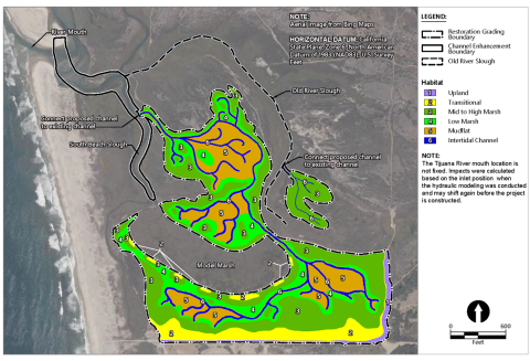
Alternative 2, identified as the Proposed Project in the EIR/EIS, proposes a restoration footprint of approximately 82.5 acres of native habitat, including 62.8 acres of intertidal wetlands, 5.1 acres of intertidal channel, and 14.6 acres of native transitional and upland habitat (Figure 4). This alternative emphasizes the restoration of low and mid- to high salt marsh habitat, with only limited areas restored to intertidal mudflat. This alternative, with its slightly smaller restoration footprint avoids areas of transitional and native upland plant communities that would be restored to wetlands under Alternative 1.
Also evaluated was the no project alternative, which would result in no changes to the current conditions within the southwestern portion of the Tijuana River Valley.
A description of these restoration alternatives and the associated environmental effects of implementing them, along with an analysis of the no project alternative, is provided in the FEIR/EIS, which is available for review at: https://trnerr.org/about/public-notices/.
To Review Print Copies of the ROD and FEIR/EIS
To review printed copies of these documents, visit the Tijuana Estuary Visitor Center at 301 Caspian Way, Imperial Beach, CA 91932, telephone 619-575-3613. The Visitor Center is open Wednesday - Sunday, 10:00 a.m. – 5:00 p.m. (but you are advised to call first to verify office hours).
Environmental Review Process
The USFWS and CA State Parks, as the respective lead agency under the National Environmental Policy Act and the California Environmental Quality Act, issued a Notice of Intent to prepare a draft EIR/EIS for the TETRP II Phase I project on May 27, 2021.
The Notice of Availability of the draft EIR/EIS was published in the Federal Register on August 19, 2022. A 45-day review period was provided for the public and agencies to review the draft EIR/EIS and provide comments. Two virtual public meetings were held on September 8, 2022.
Six comment letters were received during the public comment period. Commenters included the Environmental Protection Agency, California Department of Fish and Wildlife, County of San Diego, San Diego Audubon Society, and two members of the public. In accordance with 40 CFR §1502.17(b), Chapter 8 of the FEIR/EIS includes a summary presenting all alternatives, information, and analyses submitted by State, Tribal, and local governments, and other public commenters for consideration by the lead and cooperating agencies in developing the FEIS/EIR. Some changes were made to the text of the EIR/EIS in response to the comments. The comment letters and responses to those comments are provided in Appendix D of the FEIR/EIS.
The Notice of Availability (NOA) of the FEIS was published in the Federal Register on March 31, 2023. Three comment letters were received and are included in the ROD as Attachment 4.
The USFWS issued the Record of Decision on May 24, 2023.
For More Information
For questions or other information, please contact Victoria Touchstone, Conservation Planner, at Victoria_Touchstone@fws.gov.
Project Partners