
What We Do
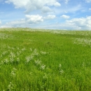
Habitats are managed using techniques such as prescribed grazing and fire, haying, and the farming and reseeding of former croplands to herbaceous cover. Most of the wetlands on waterfowl production areas within the refuge complex are subject to natural flooding and drying cycles and are not intensively managed or manipulated.
Grazing
Grazing is an important management tool in the District and is important for maintaining healthy grasslands on our waterfowl production areas. When used properly, grazing removes old vegetation, stimulates new plant growth, restructures vegetation, affects plant species composition, and enhances animal diversity. Hoof impact by grazing animals can break up capped soils, improve the water cycle, stimulate vegetative reproduction of stoloniferous grasses, and enhance the decomposition of old plant material by breaking up plant litter. Hoof action can also distribute and trample seeds into soils, increasing chances of successful germination. Nutrients are returned to the soil in the form of urine and feces.
Prescribed Fire
Fire can be very important to the natural health and vigor of grasslands and shrublands and is used as a management tool on waterfowl production areas throughout the District. Fire is used to remove litter and ladder fuel, control noxious weeds, reduce woody vegetation or to improve the height and density of plant cover. Fire releases nutrients tied up in vegetative matter and removes dead vegetation that inhibits new growth. Fire can suppress exotic plant species and prevent the invasion of woody species, such as juniper, into native grasslands; however, fire may also allow invasion of fire tolerant species such as cheat grass and spotted knapweed. Regrowth following fire can be especially attractive to wildlife because of the increased nutrition and palatability of new plants.
Haying and Mowing
Haying and mowing management strategies are generally used to enhance tame grass or tame grass/legume stands and to control spread of invasive weeds. Haying temporarily removes residual, dead, and matted vegetation and stimulates new growth, which improves habitat structure and diversity. Seed production, seed germination, and growth of desirable plants can result from properly timed haying.
Cooperative Farming
When lands are included in the Refuge System as waterfowl production areas, they often contain cropland or degraded stands of tame grasses instead of native habitat conditions. In these cases, the cropland is usually seeded back to native cover or, where restoration to a native condition is not feasible, to Dense Nesting Cover for waterfowl. If tame grass stands are in very poor condition or have serious weed problems, farming to create a clean seedbed may be required for 2 – 4 years. Farming and seeding is used only to reestablish grassland or nesting cover and return an altered landscape to a more native condition.
Water Management
Most of the wetlands on Waterfowl Production Areas within the District are subject to natural flooding and drying cycles and are not intensively managed or manipulated.
Management and Conservation
U.S. Fish and Wildlife Service Conservation Areas are established under the authority of the Fish and Wildlife Act of 1956. The “Conservation Area” designation simply outlines a boundary within which the USFWS may use Land and Water Conservation Fund Act funds (in addition to other funding sources) to purchase easements from willing sellers.
Blackfoot Valley Conservation Area
The Blackfoot Valley Conservation Area boundary was established in 1997. The Conservation Area is part of a conservation strategy to protect one of the last undeveloped, low-elevation river valley ecosystems in western Montana. The project area encompasses an 824,024 acre ecosystem that includes parts of Missoula, Powell, and Lewis & Clark Counties. Parts of these counties make up the Blackfoot River watershed in western Montana and include the Ovando Valley and the Helmville Valley. The Blackfoot River watershed is one of the most biologically diverse and intact landscapes in the western United States. The watershed supports an estimated 250 species of birds, 63 species of mammals, 5 species of amphibians, 6 species of reptiles, and 25 species of fish.
As of 2011, the USFWS had obtained 43,991 acres of wetland, grassland, and conservation easements within the project area. Each individual easement has a variety of rights secured in the purchase, including protection of grasslands from being plowed; prohibiting the draining, burning, or filling of wetlands; and protection of habitats from being subdivided and developed. Easements are purchased or donated from willing sellers who maintain ownership and management of their land.
Rocky Mountain Front Conservation Area
The Rocky Mountain Front Conservation Area was established in 2006. The conservation area conservation area
A conservation area is a type of national wildlife refuge that consists primarily or entirely of conservation easements on private lands. These conservation easements support private landowner efforts to protect important habitat for fish and wildlife and major migration corridors while helping to keep agricultural lands in production.
Learn more about conservation area is part of a larger landscape conservation strategy to protect a unique, highly diverse, and mostly unfragmented ecosystem. Outside of Alaska, the Rocky Mountain Front is one of the last truly wild places in North America; virtually every wildlife species found there on the arrival of Lewis and Clark in 1806, with the exception of free-ranging bison, remains today. In addition, it is the only area in the continental United States with a complete group of carnivorous mammals including grizzly bear, gray wolf, wolverine, American marten, and Canada lynx. The conservation area is nested within the District and includes parts of Lewis & Clark, Teton, and Pondera Counties. The project area is bordered by the Bob Marshall Wilderness to the west, the Blackfeet Indian Reservation to the north, and its eastern boundary generally follows highways 89 and 287.
As of 2011, the USFWS had protected a total of 76,847 acres through conservation easements. Each individual easement has a variety of rights secured in the purchase, including protection of grasslands from being plowed; prohibiting the draining, burning, or filling of wetlands; and protection of habitats from being subdivided and developed. Easements are purchased or donated from willing sellers, who maintain ownership and management of their land.
Swan Valley Conservation Area
The Swan Valley Conservation Area was established in 2012 as a strategy to protect one of the last undeveloped, low elevation coniferous forest ecosystems in western Montana. The Swan Valley is situated between the roadless areas of the Glacier National Park/Bob Marshall Wilderness Complex, the Mission Mountains Wilderness, and the Bitterroot/Selway Wilderness Complex to the southwest. As such, it provides an avenue of connectivity between the Canadian Rockies and the Central Rockies of Idaho and Wyoming. Unlike many other rural valleys in Montana, Swan Valley has the potential to maintain its role in connecting the surrounding landscapes; however, a combination of depressed timber markets and high recreational values of the land have recently threatened not only the connectivity for wildlife, but are also impacting the traditional rural way of life for residents of the Swan Valley.
To date, the USFWS has protected 80 acres, which was donated as a conservation easement conservation easement
A conservation easement is a voluntary legal agreement between a landowner and a government agency or qualified conservation organization that restricts the type and amount of development that may take place on a property in the future. Conservation easements aim to protect habitat for birds, fish and other wildlife by limiting residential, industrial or commercial development. Contracts may prohibit alteration of the natural topography, conversion of native grassland to cropland, drainage of wetland and establishment of game farms. Easement land remains in private ownership.
Learn more about conservation easement in 2012.
Benton Lake Waterfowl Production Areas
Arod Lakes Waterfowl Production Area
Size:797 acres
Location:8.5 miles southwest of Brady
Habitat:Arod Lakes Waterfowl Production Area is comprised of 169 acres of wetlands and 628 acres of tame grassland which are managed as Dense Nesting Cover. Arod Lakes Waterfowl Production Areasupports a large population of yellow perch and northern pike, which make it a popular area for year-round fishing. The waterfowl production area waterfowl production area
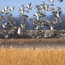
Waterfowl production areas are small natural wetlands and grasslands within the National Wildlife Refuge System that provide breeding, resting and nesting habitat for millions of waterfowl, shorebirds, grassland birds and other wildlife. Virtually all waterfowl production areas are in the Prairie Pothole Region states of Iowa, Minnesota, Montana, North Dakota and South Dakota.
Learn more about waterfowl production area is also a popular area for upland game bird hunting.
Facilities:Arod Lakes Waterfowl Production Area is cooperatively managed with Montana Fish, Wildlife and Parks. State provided facilities include a boat ramp that allows motorized boats, a small designated camping area, a bathroom, and limited motorized vehicle access for ice fishing three months of the year.
Special Regulations:Motorized watercraft are permitted on Arod Lakes Waterfowl Production Area. Open fires and overnight parking are limited to the designated camping area. The road to Middle Lake and Round Lake is open to motorized vehicles from January 2 - March 31.
Directions
From Brady: Travel west on Central Ave. Turn left/south at the “T” (S. Curtis St./May 3rd St.). This road takes a slight right as it becomes Arod Lakes Road. After about 2.5 miles, turn left to stay on Arod Lakes Road. Continue on Arod Lakes Road as it turns into 28th Road NW. Turn left/south onto 3rd Lane NW. In about 1.7 miles, turn left/east onto Arod Lakes Access Road.
Fun Fact
Arod Lakes Waterfowl Production Area is home to a breeding colony of American White Pelicans that nest on an island in Arod Lake from April to mid-August. Bring your binoculars and you may be able to spot a pelican chick!
Big Sag Waterfowl Production Area
Size: 350 acres
Location: 3 miles northeast of Highwood
Habitat: Big Sag Waterfowl Production Area is comprised of a large, 169 acre wetland and 181 acres of tame grassland.
Facilities: There are no designated parking areas at Big Sag Waterfowl Production Area . Use caution when parking on the side of the road.
Directions
From Highwood: Travel northeast on Highwood Road/Hwy 228 for about 3 miles. Big Sag Waterfowl Production Area is located on the north side of the road.
Blackfoot Waterfowl Production Area
Size: 1,873 acres
Location: 7 miles southeast of Ovando
Habitat: Blackfoot Waterfowl Production Area is comprised of about 170 acres of wetlands, 260 acres of warm Douglas-fir forest, and about 1,300 acres of native grasslands and sagebrush sagebrush
The western United States’ sagebrush country encompasses over 175 million acres of public and private lands. The sagebrush landscape provides many benefits to our rural economies and communities, and it serves as crucial habitat for a diversity of wildlife, including the iconic greater sage-grouse and over 350 other species.
Learn more about sagebrush -steppe. The Blackfoot River runs through the southern-most portions of the Waterfowl Production Area.
Facilities: Two gravel parking lots are provided for your convenience. They are located on Hwy 200.
Caution: Bring your bear spray! Grizzly bears are a common sight on Blackfoot Waterfowl Production Area
Directions
From Ovando: Travel east on Hwy 200 for approximately 8 miles. Blackfoot Waterfowl Production Area is located on both sides of the road.
Blackhurst Waterfowl Production Area
Size: 320 acres
Location: 4 miles north of Ferdig
Habitat: Blackhurst Waterfowl Production Area is comprised of approximately 43 acres of wetlands and 277 acres of tame grassland.
Facilities:There are no designated parking areas at Blackhurst Waterfowl Production Area. Use caution when parking on the side of the road.
Directions
From Ferdig: Drive north approximately 4 miles. Blackhurst Waterfowl Production Area is located on the west/left side of the road.
Brown Waterfowl Production Area
Size: 260 acres
Location:3.5 miles northeast of Sunburst
Habitat: Brown Waterfowl Production Area is characterized by 45 acres of wetlands nestled amongst the surrounding tame grassland.
Facilities:There are no designated parking areas at Brown Waterfowl Production Area. Use caution when parking on the side of the road.
Directions
From Sunburst: Drive east on Nine Mile Road. Turn left/north on Three Mile Road and drive approximately 2 miles north. Brown Waterfowl Production Area is located on the left/west side of the road.
Brumwell Waterfowl Production Area
Size:252 acres
Location:4 miles north of Power
Habitat:Brumwell Waterfowl Production Area is comprised of 179 acres of shallow wetlands and 73 acres of tame grassland. Visitors can expect to see numerous species of waterfowl and shorebirds.
Facilities: There are no designated parking areas at Brumwell Waterfowl Production Area. Use caution when parking on the side of the road.
Directions
From Power:Drive north on 15th Lane NE, which is the frontage road that runs alongside the west side of I-15. Brumwell Waterfowl Production Area will be on your left/west.
From Great Falls: Drive north on I-15 for approximately 20 miles. Take the exit for Power (Exit 302). Turn left/west on 7th Rd. NE/MT-431. Turn right/north on 15th Lane NE, which is the frontage road that runs parallel to I-15. Drive north for approximately 4 miles. Brumwell Waterfowl Production Area will be on the left/west side of the road.
Cemetary Waterfowl Production Area
Size:109 acres
Location: 3 miles east of Sunburst
Habitat:Cemetary Waterfowl Production Area is comprised of about 72 acres of wetlands and 37 acres of tame grassland.
Facilities: There are no designated parking areas at Cemetary Waterfowl Production Area. Use caution when parking on the side of the road.
Directions
From Sunburst: Cemetary Waterfowl Production Area is located on the south side of Nine Mile Road, approximately 3 miles east of Sunburst.
Danbrook Waterfowl Production Area
Size: 327 acres
Location:6 miles east of Sweetgrass
Habitat: Danbrook Waterfowl Production Area is characterized by a large 107 acre wetland surrounded by tame grassland.
Facilities:There are no designated parking areas at Danbrook Waterfowl Production Area. Use caution when parking on the side of the road.
Directions
From Sweetgrass: Drive east on Border Road for approximately 4 miles. Turn right/south on Brown Road. Turn left/east at the “T” (Holtz Road). Danbrook Waterfowl Production Area is located on the left/north side of the road.
From Sunburst: Drive east on Nine Mile Road. Turn left/north on Three Mile Road. Turn right/east at the “T” (Holtz Road). Danbrook Waterfowl Production Area is located on the left/north side of the road.
Dunk Waterfowl Production Area
Size: 80 acres
Location:5 miles northeast of Sunburst
Habitat: Dunk Waterfowl Production Area is characterized by 28 acres of wetlands and 52 acres of tame grassland.
Directions
Dunk Waterfowl Production Area is adjacent to Long Lake Waterfowl Production Area. To get to Long Lake Waterfowl Production Area:
From Sunburst: Drive east on Nine Mile Road. Turn left/north on Iverson Road. Drive approximately 2 miles. Long Lake Waterfowl Production Area is located on both sides of the road.
Ehli Waterfowl Production Area
Size:475 acres
Location:8 miles east of Sweetgrass
Habitat: Ehli Waterfowl Production Area is comprised of 150 acres of wetlands, 154 acres of native grassland, and 171 acres of tame grassland.
Facilities:There is a small unimproved parking lot provided for your convenience.
Directions
From Sweetgrass: Drive east on Border Road for approximately 8 miles. About 1 mile after crossing Ehli Road, turn right/south just before the green USA-Canada road sign. This dirt road leads to a parking area.
From Sunburst: Drive east on Nine Mile Road. Turn left/north on Three Mile Road. Turn right/east at the “T” (Holtz Road). Turn left/north on Ehli Road. Turn right/east at the “T” (Border Road). Drive approximately 1 mile and turn right/south just before the green USA-Canada road sign. This dirt road leads to a parking area.
Fun Fact
Ehli Waterfowl Production Area is the northern-most Waterfowl Production Area in the District. It shares its northern border with Canada!
Furnell Waterfowl Production Area
Size:1,995 acres
Location: 2.5 miles south of Whitlash
Habitat: Located in the Sweetgrass Hills, Furnell Waterfowl Production Area is comprised of about 124 acres of wetlands and 1,871 acres of native grassland.
Facilities:Several unimproved parking lots are provided for your convenience.
Directions
From Whitlash: Drive west on Gold Butte Road. After about 1 mile, turn left/south on Strawberry Road. Drive south for about 2 miles. Furnell Waterfowl Production Area is located on both sides of the road.
H2-0 Waterfowl Production Area
Size:1,803 acres
Location:3 miles northwest of Helmville
Habitat:H2–O is comprised of about 235 acres of wetlands, 705 acres of tame grassland, and 863 acres of native grassland.
Facilities: There are no designated parking facilities on the H2-O Waterfowl Production Area, but there is a State parking lot available on Cut Off Road on the Aunt Molly Wildlife Management Area. Access to the H2-O Waterfowl Production Area is by foot-access only from the Cut Off Road. The driveway leading from Cut Off Road to the H2-O headquarters is for administrative use only and is closed to public motorized vehicle access. There is no visitor center or public facilities available at the H2-O administrative area. A Fish and Wildlife Service employee lives on-site at the administrative area. If assistance is needed, please call first (406-793-0050).
Special Regulations: Hunting and trapping are prohibited on H2–O Waterfowl Production Area.
Caution: Bring your bear spray! Grizzly bears are a common sight on H2–O Waterfowl Production Area
Directions
From Helmville: Drive east on Hwy 271. Turn left/north on MT-141. Stay on MT-141 for approximately 3.3 miles. Turn left/west on Cut Off Road. Travel west on Cut Off Road for about 3 miles.
Hartelius Waterfowl Production Area
Size:307 acres
Location: 5 miles north of Vaughn
Habitat: Hartelius Waterfowl Production Area is comprised of about 134 acres of wetlands and 173 acres of tame grassland.
Facilities: A small, unimproved parking area is provided for your convenience.
Special Regulations: Most of Hartelius Waterfowl Production Area is open to hunting; however there is a No Hunting Zone located around a private inholding on the Waterfowl Production Area. Please observe all No Hunting Zone signs.
Directions
From Vaughn: Travel north on the I-15 Frontage Road for about 2 miles. Turn right/east on Neuman School Road. Continue to follow Neuman School Road north for approximately 5 miles. Turn right/east on Wilson Road. The Hartelius Waterfowl Production Area parking area will be on your left/south.
Hingham Waterfowl Production Area
Size:280 acres (leased from the State)
Location:2 miles northeast of Rudyard
Habitat: Hingham Lake Waterfowl Production Area is comprised of about 113 acres of wetlands and 167 acres of native grassland.
Facilities:There are no designated parking areas at Hingham Lake Waterfowl Production Area. Use caution when parking on the side of the road.
Directions
From Rudyard: Travel north on Main St/Reed St. Turn right/east on Lincoln Street. Travel east on Lincoln Street for 1 mile, then turn left/north. Drive north for 2 miles. This will bring you to the south-west corner of Hingham Lake Waterfowl Production Area.
Jarina Waterfowl Production Area
Size:640 acres
Location: 12.5 miles west of Dupuyer
Habitat:Lying just east of the Rocky Mountains, Jarina Waterfowl Production Areais characterized by about 85 acres of wetlands and 555 acres of native grassland. There are also several aspen groves growing along either side of a rocky ridge that runs through the southern-most portion of the Waterfowl Production Area.
Facilities:A small, unimproved parking lot is provided for your convenience.
Caution: Bring your bear spray! Grizzly bears are a common sight on Jarina Waterfowl Production Area
Directions
From Duypuyer: Drive north on US 89. Turn left/west on Swift Dam Road (the road just before the rest area). Drive approximately 14 miles. Jarina Waterfowl Production Area will be on both sides of the road.
Kingsbury Lake Waterfowl Production Area
Size:3,734 acres
Location:4 miles southwest of Geraldine
Habitat:Kingsbury Waterfowl Production Area is comprised of a large 1,400 acre wetland, about 32 acres of small wetlands, 2,054 acres of native grassland, and 248 acres of tame grassland.
Facilities:A small, unimproved parking lot is provided for your convenience.
Special Regulations: Visitors maynotshoot or otherwise harm prairie dogs on Kingsbury Lake Waterfowl Production Area.
Directions
From Geraldine:Travel west on Shonkin Road. Turn left/south on Geyser Geraldine Road. Continue along Geyser Geraldine Road for about 3 miles. Kingsbury Waterfowl Production Area will be located on both sides of the road. The parking area will be on your right/north.
Fun Fact
At 3,734 acres, Kingsbury Waterfowl Production Area is the largest Waterfowl Production Area in the District!
Kleinschmidt Lake Waterfowl Production Area
Size:1,120 acres
Location: 6 miles southeast of Ovando
Habitat: Kleinschmidt Lake Waterfowl Production Area, located just west of Kleinschmidt Lake, is comprised of 58 acres of wetlands and 1,062 acres of native grassland and sagebrush-steppe.
Facilities:A small, unimproved parking lot is provided for your convenience.
Caution: Bring your bear spray! Grizzly bears are a common sight on Kleinschmidt Waterfowl Production Area
Directions
From Ovando: Travel east on Hwy 200. Turn right on Rollercoaster Road, which is the first right after you cross the bridge (approximately 0.5 miles after crossing the bridge). If you see a “Historic Marker” sign then you’ve gone too far. Stay on Rollercoaster Road until you see the sign for Kleinschmidt Waterfowl Production Area (approximately 2 miles).
Long Lake Waterfowl Production Area
Size:646 acres
Location:3.5 miles northeast of Sunburst
Habitat: Long Lake Waterfowl Production Area is characterized by 297 acres of wetlands and 349 acres of tame grassland.
Facilities: There are no designated parking areas at Long Lake Waterfowl Production Area. Use caution when parking on the side of the road.
Directions
From Sunburst: Drive east on Nine Mile Road. Turn left/north on Iverson Road. Drive approximately 2 miles. Long Lake Waterfowl Production Area is located on both sides of the road.
Peterson Waterfowl Production Area
Size:94 acres
Location:10 miles northeast of Santa Rita
Habitat:Peterson Waterfowl Production Area is characterized by approximately 28 acres of wetlands, 15 acres of native grassland, and 51 acres of tame grassland.
Facilities: There are no designated parking areas at Peterson Waterfowl Production Area. Use caution when parking on the side of the road.
Directions
From Cut Bank:Drive north on Highway 213/Santa Rita North. Continue north on Highway 214/Santa Rita North. Turn right/east on Tipville Road. Turn left on Sweetgrass Road. Peterson Waterfowl Production Area is located on the left/west side of the road.
Sands Waterfowl Production Area
Size:379 acres
Location:3 miles west of Havre
Habitat:Sands Waterfowl Production Area is characterized by 166 acres of wetlands, 129 acres of native grassland, and 84 acres of tame grassland.
Facilities:A small, unimproved parking area/pull-off is provided for your convenience. Please use caution when parking on the side of the highway.
Special Regulations: Hunting and trapping are prohibited on Sands Waterfowl Production Area.
Directions
From Havre:Drive west on Highway 2. Turn left/south on Highway 87. Sands Waterfowl Production Area is located on the west side of the highway.
Savik Waterfowl Production Area
Size:397 acres
Location:1.5 miles southwest of Bynum
Habitat:Savik Waterfowl Production Area is characterized by 254 acres of shallow marsh-like wetlands nestled amongst 143 acres of native grassland.
Facilities:There is a small unimproved parking lot provided for your convenience. Please do not block the gate.
Caution: Bring your bear spray! Grizzly bears are a common sight on Savik Waterfowl Production Area
Directions
From Bynum:Drive approximately 1 mile south on Highway 89. Savik Waterfowl Production Area is located on the west side of the highway.
Schrammeck Lake Waterfowl Production Area
Size: 420 acres
Location: 8 miles southeast of Cascade
Habitat: Schrammeck Lake Waterfowl Production Area consists of a 300 acre wetland surround by 120 acres of tame grassland.
Facilities:A small unimproved parking area is provided for your convenience.
Directions
From Cascade: Drive east out of Cascade on Central Avenue, which becomes Cascade Hound Creek Road. Continue to follow Cascade Hound Creek Rd. for approximately 10.5 miles (you will have to veer right/south at the first “Y” and veer left/west at the second “Y”). Turn left/north on Schrammeck Lake Road. Drive north on Schrammeck Lake Rd. for about 1 mile, then turn left/west. This road will bring you to a small parking area for Schrammeck Lake Waterfowl Production Area.
Upsata Waterfowl Production Area
Size:119 acres
Location: 5.5 miles northeast of Ovando
Habitat: Upsata Lake Waterfowl Production Area is bordered to the northwest by Upsata Lake, a permanent glaciated lake located in the heart of the knob and kettle topography of the Blackfoot River watershed. The WPA is comprised of about 31 acres of wetlands and 88 acres of native grasslands.
Facilities: A State boat launch, parking lot, bathroom, and picnic area are located on Upsata Lake Road along the western boundary of the waterfowl production area.
Special Regulations:Only the eastern portion of the waterfowl production area is open to hunting. Please pay close attention to “No Hunting Zone” signs.
Caution: Bring your bear spray! Grizzly bears are a common sight on Upsata Lake Waterfowl Production Area
Directions
From Ovando: Travel west on Hwy 200 for approximately 7 miles. Turn right/north on Woodworth Road (at the pullout with the “Blackfoot-Clearwater Wildlife Management Area” sign). Turn right/east at the “t” onto Upsata Lake Road. Drive east on Upsata Lake Road for approximately 1.5 miles. Upsata Lake Waterfowl Production Area will be located on the left/north side of the road.
Our Services
Permits
Permits are generally not required for individuals wishing to participate in hunting, fishing, wildlife observation, photography, environmental education, and interpretation. A Special Use Permit may be required if the activity is conducted for commercial use or financial gain. Examples of activities that may require a Special Use Permit include organized group activities, research, commercial photography, grazing, haying, seismic operations, and utility maintenance projects.
Please contact the Wetland District Manager at 406-727-7400 ext. 228 to obtain a permit or if you have questions about which activities require a permit.
Law Enforcement
Law Enforcement officers at the Benton Lake Wetland Management District help visitors understand and obey the laws that protect our natural resources and provide for public safety. District officers work closely with state and local government offices to enforce federal and state hunting regulations that protect wildlife from illegal take and preserve legitimate hunting opportunities.
Laws and Regulations
If you have questions regarding the rules and regulations or are in doubt about a specific activity, please contact the Wetland Management District headquarters at 406-727-7400.