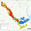
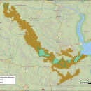
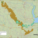
Working closely with landowners, the U.S. Fish and Wildlife Service is proposing to expand Roanoke River National Wildlife Refuge’s acquisition boundary to allow for the conservation of a contiguous forested riparian riparian
Definition of riparian habitat or riparian areas.

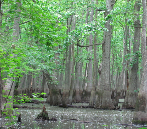
Learn more about riparian
corridor along a 137-mile stretch of the Roanoke River extending from the Weldon area to the Albemarle Sound. The proposal identifies a 287,090-acre Conservation Partnership Area that contains 93,000 acres already managed for conservation by public and private entities and would enable the Service to acquire up to 50,000 acres in fee-title acquisitions from willing sellers and up to 100,000 acres in conservation easements or cooperative agreements with willing private landowners.
 

The proposal, including possible impacts and alternatives, is now available for public review alongside the draft Land Protection Plan and Environmental Assessment. The U.S. Fish and Wildlife Service hosted two public meetings, one at 7 p.m. on December 14, 2023 at the Windsor Community Building, 201 S. Queen Street, Windsor, N.C., 27983, and the other virtual, at 2 p.m., on December 152023. The virtual meeting was recorded and is available below.

All interested parties have the opportunity to participate and provide comments during the open 30-day comment period. Please submit comments to Roanokeriver@fws.gov. Comments will be accepted until Jan 4, 2024. 

Library

Draft Land Protection Plan and Environmental Assessment for the Proposed Expansion of Roanoke River National Wildlife Refuge

In accordance with U.S. Fish and Wildlife Service (Service) policy and the National Environmental Policy Act, a draft Land Protection Plan and Environmental Assessment have been prepared analyzing the effects and describing the strategy of establishing a 287,090-acre Conservation Partnership...

Roanoke River National Wildlife Refuge Proposed Expansion Alternative B Prioritized Lands Map

This map, from the draft Land Protection Plan for Roanoke River National Wildlife Refuge and Environmental Assessment, depicts how lands within the Proposed CPA boundary are prioritized by location and significance to wildlife. The map shows the current approved acquisition boundary, refuge...

Proposed Expansion of Roanoke River National Wildlife Refuge Alternative A Map

This map from the draft Land Protection Plan for Roanoke River National Wildlife Refuge and Environmental Assessment shows Alternative A (the No-Action Alternative). The map shows the existing Roanoke River NWR Approved Acquisition Boundary and current Refuge Lands in relation to the Northampton...

Proposed Expansion of Roanoke River National Wildlife Refuge Alternative B Map

This map from the draft Land Protection Plan for Roanoke River National Wildlife Refuge and Environmental Assessment shows Alternative B ( the Service's Proposed Action). The boundary of Alternative B is shown in relation to the existing Roanoke River NWR Approved Acquisition Boundary and...

Proposed Expansion of Roanoke River National Wildlife Refuge Alternative C Map

This map from the draft Land Protection Plan for Roanoke River National Wildlife Refuge and Environmental Assessment shows Alternative C in relation to the existing Roanoke River NWR Approved Acquisition Boundary and current Refuge Lands. The map also shows the location of Alternative C in...

Proposed Expansion of Roanoke River National Wildlife Refuge Alternative D Map

This map from the draft Land Protection Plan for Roanoke River National Wildlife Refuge and Environmental Assessment shows Alternative D in relation to the existing Roanoke River NWR Approved Acquisition Boundary and current Refuge Lands. The map also shows the location of Alternative D in...

Programs

A bright blue sky obstructed by fluffy white clouds reflected off of a stream shot from inside a kayak
The U.S. Fish and Wildlife Service manages an unparalleled network of public lands and waters called the National Wildlife Refuge System. With more than 570 refuges spanning the country, this system protects iconic species and provides some of the best wildlife viewing opportunities on Earth.
A bright orange sky with a setting sun with a pond and vegetation in the foreground
The realty division of the National Wildlife Refuge System supports the acquisition and management of U.S. Fish and Wildlife Service lands, using Migratory Bird Conservation and Land and Water Conservation Fund dollars.

Facilities

A calm river bordered by bare baldcypress trees
Roanoke River National Wildlife Refuge, in Bertie County, North Carolina, is named for the Roanoke River, which runs through the refuge. The refuge was established in 1991 to protect the forests in the Roanoke River floodplain, considered to be the largest intact, and least disturbed, bottomland...
A brown-and-white building with a garden and several parking spaces
The Coastal North Carolina National Wildlife Refuges Gateway Visitor Center (Gateway Visitor Center in short) represents eleven national wildlife refuges and one national fish hatchery, offering an invitation to visit them all. Interactive exhibits teach visitors about each of the refuges in the...