Written By

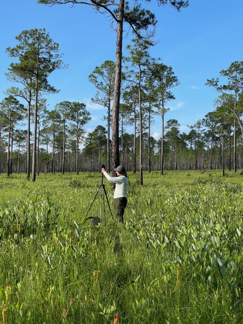
Three months ago, I began working on an Interagency Terrestrial Light Detection and Ranging (LiDAR) Monitoring Project as part of the USFWS 2022 Directorate Fellow Program (DFP). The project and DFP provided me the opportunity to live at Mississippi Sandhill Crane National Wildlife Refuge in Mississippi and work throughout the Gulf Coast National Wildlife Refuge Complex for the entire summer. My field partner and I have been using terrestrial LiDAR-based vegetation surveying technology to gather data that will help land managers and inform the public about active fire management throughout the complex.
LiDAR is a type of remote sensing technology that uses a laser to gather millions of data points from its surroundings to render a highly accurate 3D model. A quick, five-minute scan can record detailed characteristics about the surrounding ecosystem that fire managers can use for many years to determine fuel loading, wildlife habitat health, and post-fire impacts. The data provides a clearer understanding of what is occurring at the ground level and allows for easier landscape change comparisons over time.
For me, working throughout the Gulf Coast National Wildlife Refuge Complex has been surreal. I grew up in the Northeastern United States, which is dominated with temperate broadleaf and mixed forests. Encountering the fire-dependent Longleaf Pine Savanna ecosystem that thrives within the complex is a sight to behold when you aren’t familiar with it. In fact, only 3% of this rare ecosystem type remains on the planet, much of it right here within the complex. To top it off, the last remaining population of the elusive Mississippi sandhill crane also resides within the complex. Thanks to half a century of dedicated and ongoing management efforts, these ancient birds can still be seen soaring over a colorful meadow of pitcher plants, rare orchids, and longleaf pines – a sight best described as prehistoric.
Many of the land management efforts to protect these unique longleaf pine forests and Mississippi sandhill cranes include proper wildland fire management. The LiDAR data collected paints a clear picture of pre- and post-fire conditions of site-specific areas. Ecologically meaningful metrics can be used to predict fire risk, develop site-specific fire impact studies, and create post-fire management plans.
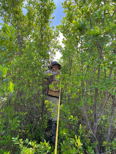
The actual fieldwork and data collection can be monotonous and physically challenging. Over the weeks I’ve dedicated to this project, I’ve noticed that what we struggled to learn and do in the beginning has now evolved into a rhythm: Hike to the plot. Set up the tripod. Turn on the laser. Hike away and wait. Untangle from the greenbriar wrapped around your leg. Repeat. Naturally, I learned appreciation and joy in what I used to describe as monotonous. Each day has allowed me to become more intimately connected with my surroundings, becoming more and more immersed in the diversity and beauty of this ecosystem. Hosting the highest plant diversity per square meter, the area always has something to discover. Central to this biodiversity is fire on the landscape. What can sometimes seem like a destructive force, fire has created more diversity here than anywhere I've ever been before.
As the summer marched on, we navigated to different plots to study and collect data. Each location revealed a new path and with it, opportunities to learn. On an early morning in mid-June, after a seemingly endless hike through black needle rush as tall as our chins, we suddenly stepped out into an incredible landscape of an open mud flat. The sun rising over the estuary cast sparkling sunlight onto hundreds of fiddler crabs that were just crawling out of their underground homes upon our arrival. As I think back over the summer, it’s easy to appreciate those moments of traversing acres of pine flatwoods, recently burned forests, cypress swamps, and open savannas.
I started my DFP at an orientation at the National Conservation Training Center in West Virginia. Each of us was given a copy of The Home Place by J. Drew Lanham – a book that coincidentally takes place in the rural South. Several weeks later, as I sat on the bunkhouse patio that overlooks the Longleaf Pine Savanna, I read a passage, “I believe the best way to begin reconnecting humanity's heart, mind, and soul to nature is for us to share our individual stories.” I couldn't have said it better myself.
- Explore fws.gov/careers for an overview of internships, job opportunities, career paths, and getting started in conservation at USFWS.
Written By