Map of Busseltown Unit South, Tennessee National Wildlife Refuge, Cooperative Farming Opportunity

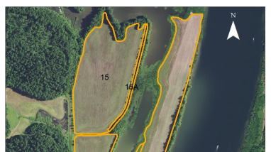
This map depicts the southern portion of the Busseltown Unit at Tennessee National Wildlife Refuge. This map shows the various tracts available for a cooperative farming opportunity on the refuge.

Publication date
Type of document
Map
Facility
An image of a green heron crouching on a log.
Encompassing over 51,000 acres of forests, farmland and grasslands, Tennessee National Wildlife Refuge was established in 1945 to provide feeding, resting, and nesting habitat for migratory birds.
Media Usage Rights/License
Public Domain
Program
A bright blue sky obstructed by fluffy white clouds reflected off of a stream shot from inside a kayak
The U.S. Fish and Wildlife Service manages an unparalleled network of public lands and waters called the National Wildlife Refuge System. With more than 570 refuges spanning the country, this system protects iconic species and provides some of the best wildlife viewing opportunities on Earth.