The U.S. Fish and Wildlife Service (USFWS) and the National Park Service (NPS) are inviting public review and comment on a proposal from the North Carolina Department of Transportation (NCDOT) to realign a section of N.C. Highway 12 on Pea Island National Wildlife Refuge.
NCDOT has submitted a preliminary application to USFWS proposing to realign approximately 0.63 miles of the existing two-lane roadway about 180 feet to the west (centerline to centerline).
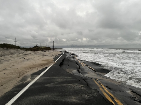
The purpose of the proposed realignment is to reduce vulnerability to coastal hazards. Nor’easters in late September and mid-October 2026 damaged roughly 1,200 feet of pavement, severed road access to Hatteras Island for multiple days, and required activation of the Rodanthe–Stumpy Point emergency ferry. NCDOT is currently implementing temporary sandbag protection as a short-term measure for the existing highway. The realignment is intended to qualify for emergency funding and provide more reliable access while longer-term solutions are developed through NCDOT’s ongoing Planning and Environmental Linkages (PEL) study for the Pea Island corridor.
Proposed actions include:
- Request for a new 100-foot highway easement (50 feet each side of the new centerline) and abandonment of the existing easement after removal of the old road.
- Construction of a new 30-foot-wide paved two-lane road immediately adjacent to the existing Cape Hatteras Electric Cooperative (CHEC) power line.
- Relocation of one power pole (Pole 75) approximately 15 feet west within the existing CHEC easement.
- Filling of approximately 1,714 square feet of potential jurisdictional wetlands and 2,317 square feet of open waters at the “turtle pond” behind the restrooms.
- Complete removal of the existing roadway and sandbags once traffic is switched to the new alignment.
- Construction of a new dune (approximately 15 feet high and 45 feet wide) largely within the existing highway easement, sprigged with sea oats or American beach grass depending on season.
- Demolition and reconstruction or relocation of the Pea Island National Wildlife Refuge Visitor Center, associated parking, and the North Pond restrooms and wastewater system, and adjustments to access for the North Pond Wildlife Trail and gated refuge administrative access.
Public comments will be accepted from November 10 through November 24, 2026.
Project information and instructions for submitting comments are available on the NPS Planning, Environment, and Public Comment website. Additionally, public comments may be submitted via email to alligatorriver@fws.gov or by mail to P.O. Box 1969, Manteo, NC 27954.
Thank you for your interest and participation.
Frequently Asked Questions
Who manages the federal lands crossed by NC-12?
NC-12 traverses lands managed by both the Cape Hatteras National Seashore and Pea Island National Wildlife Refuge. The North Carolina Department of Transportation (NCDOT) holds the highway right-of-way and is responsible for operating and maintaining NC-12 where it crosses National Park Service lands within the Cape Hatteras National Seashore and U.S. Fish and Wildlife Service lands within Pea Island National Wildlife Refuge. These federally managed lands do not include the villages of Rodanthe, Waves, Salvo, Avon, Buxton, Frisco, and Hatteras, or most of Ocracoke Village.
What is an NC-12 hotspot?
NC-12 hotspots are locations where erosion has made the highway vulnerable to ocean overwash during elevated seas and wave action. Waves can leave deep water on the highway or damage the asphalt, causing travel delays or temporary closures.
What have Cape Hatteras National Seashore and Pea Island National Wildlife Refuge done to help NCDOT manage NC-12 in vulnerable areas?
Cape Hatteras National Seashore and Pea Island National Wildlife Refuge work with the NCDOT on routine highway maintenance issues and permits for protective measures such as sandbag installation, dune building, dune plantings, and roadway repairs. They also work with NCDOT on long-range planning and on oversight of large projects such as bridge construction.
Who is responsible for land management along the Pea Island section of NC-12?
Pea Island National Wildlife Refuge, which is part of Cape Hatteras National Seashore, covers about 13 miles of northern Hatteras Island and is administered by the U.S. Fish and Wildlife Service. In partnership with the Refuge, the National Park Service administers recreational uses that are not inconsistent with the purposes of the Refuge.
What agency makes transportation management decisions in the Pea Island area?
NCDOT is responsible for operating and maintaining NC-12. Because the area is managed as a refuge, the U.S. Fish and Wildlife Service has the authority and responsibility for decision-making, including ensuring that activities are compatible with the purposes of the refuge.
Pea Island National Wildlife Refuge and Cape Hatteras National Seashore collaborate to evaluate transportation management proposals submitted by NCDOT.
Have Cape Hatteras National Seashore or Pea Island National Wildlife Refuge denied requests from the North Carolina Department of Transportation to move NC-12 near hotspots, such as the Canal Zone, the Pea Island Visitor Center, or northern Ocracoke?
No. Cape Hatteras National Seashore and Pea Island National Wildlife Refuge have not denied any requests to move the highway.
Who is proposing the current NC-12 realignment near the Pea Island Visitor Center, and what is the status of the application?
NCDOT is proposing the realignment and submitted a preliminary right-of-way modification application to the U.S. Fish and Wildlife Service on November 2, 2026. The U.S. Fish and Wildlife Service is reviewing the application and working with NCDOT to obtain additional information needed to finalize the application. No final decision has been made regarding the proposed right-of-way modification.
Can NC-12 be moved to the levee that surrounds the impoundments on Pea Island National Wildlife Refuge?
Pea Island National Wildlife Refuge manages waterfowl impoundments adjacent to NC-12.These impoundments are surrounded by earthen levees, which also serve as designated hiking trails.While limited administrative vehicle use occurs on the levees to maintain refuge lands and facilities, they are not roadways and cannot safely serve as an alternative to NC-12.
Is the Pea Island Visitor Center and the associated restroom being closed permanently?
No final decisions have been made regarding visitor facilities. The proposal includes reconstruction, relocation, or replacement of facilities affected by the proposed road realignment. Any future actions would be subject to planning, funding, environmental review, and approval processes.
How will the proposal affect refuge resources and visitor experiences?
Protecting refuge resources while maintaining safe public access is a priority. The U.S. Fish and Wildlife Service and National Park Service are evaluating how the proposal could affect wildlife habitat, visitor services, and public access opportunities. Any future action would be implemented in accordance with applicable environmental review and permitting requirements.