How can I participate?
The U.S. Fish and Wildlife Service is requesting comments on draft Land Protection Plans and an Environmental Assessment (EA) for Aransas and Big Boggy National Wildlife Refuges. The full text of the plans and EA can be found below. Please send comments or questions to r2_plancomments@FWS.gov. Comments will be accepted until January 26, 2024.
Aransas Draft Land Protection Plan
Big Boggy Draft Land Protection Plan
What is the intent of these plans?
The Service has prepared these draft plans with the intent of establishing a limited acquisition boundary for Aransas and Big Boggy National Wildlife Refuges. Within the proposed boundaries, the Service would work only with willing sellers to expand conservation through fee title and conservation easement conservation easement
A conservation easement is a voluntary legal agreement between a landowner and a government agency or qualified conservation organization that restricts the type and amount of development that may take place on a property in the future. Conservation easements aim to protect habitat for birds, fish and other wildlife by limiting residential, industrial or commercial development. Contracts may prohibit alteration of the natural topography, conversion of native grassland to cropland, drainage of wetland and establishment of game farms. Easement land remains in private ownership.
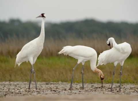
Learn more about conservation easement acquisitions consistent with our Strategic Growth Policy. The goal is to deliver in-perpetuity conservation on up to 150,000 acres of land, 95,000 for Aransas NWR and 55,000 acres for Big Boggy NWR. Acquiring these lands or easements is intended to enhance wildlife populations through the protection of habitats for such species as whooping crane, black rail, mottled duck, Attwater’s prairie-chicken and other species of high conservation value. In addition, these protections will help prevent the future listing of endangered or threatened species and support the delisting of listed species.
Where do the plans apply?
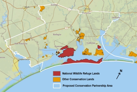
The total planning area for both plans encompasses a portion of the Gulf Coast Prairies and Marshes ecoregion in the Coastal Bend region of Texas where viable habitats for the previously listed species still remain. The planning area includes all or portions of Aransas, Calhoun, Goliad, Jackson, Matagorda, Refugio, San Patricio and Victoria counties.
How was the plan developed?
These plans represent many years of research, cooperation, and iterative planning by the Service and its’ conservation partners in the region. In 2017, the Director of the Service approved a Land Protection Strategy, acknowledging the sound scientific basis for these plans and approving the acquisition of up to 150,000 acres of land in fee or easement. The Land Protection Strategy provided the outline for the more detailed plans discussed in this document.
The plans made use of a scientific model that indicates the areas of potential inundation given a 1-meter rise in seal-level by 2100. As a result of this rise in sea-level, species of conservation concern are anticipated to need to migrate inland to find more appropriate habitat. This migration emphasizes the need for protecting more inland areas and for creating connected corridors of protected lands.
The preparation of this plan was possible with the support of numerous conservation partners across the Gulf Coast Prairies and Marshes ecoregion in Texas. The Service is grateful for everyone whose scientific contributions, planning support, and methodical input is reflected in this draft.
Project Area Map – Aransas National Wildlife Refuge
Project Area Map - Big Boggy National Wildlife Refuge

Frequently Asked Questions
If I own land in the acquisition boundary, would I ever be forced to sell?
No. All property or easement acquisition by the Service would be on a voluntary basis (willing buyer/willing seller only) and only lands in which the Service acquires a fee/title realty interest would become part of a refuge. Lands identified in the acquisition boundary are in private or public ownership. It is not the intent of the Service to acquire lands already in public ownership. Only in the presence of willing sellers of private land and only after detailed planning could lands be acquired for the refuge.
If I own land in an area that the Service says has high natural resource values, will my property ever be condemned?
The Service will not use eminent domain or condemnation to acquire lands. As the opportunity arises, the Service will acquire land or easements from interested landowners within the acquisition boundaries who wish to sell or place easements on their land for the conservation of wildlife.
Will my rights as a property owner be infringed as a result of the refuge expanding its boundaries?
No. If lands are developed into a National Wildlife Refuge, the Service will have no more authority over private land within or adjacent to the boundaries of the refuge than any other landowner. Landowners retain all the rights, privileges, and responsibilities of private land ownership.
I am a landowner; how will a conservation easement or fee-title sale benefit me?
Conservation easements provide permanent protection to natural resources while retaining private landownership. The landowner retains ownership of the land but sells certain rights identified and agreed upon by both parties. The value a landowner may expect to receive for an easement is dependent on the number of rights the landowner chooses to sell. Because ownership of the land remains with the individual, the property remains on the state and local tax rolls. The Service pays fair market value for property and any rights purchased.
Fee-title acquisition involves an interested landowner requesting the U.S. Fish and Wildlife Service acquire most or all the rights to their property. There is a total transfer of property with the formal conveyance of a title to the federal government. In some instances, certain rights such as water rights, mineral rights or use reservations, such as grazing, can be negotiated at the time the property is transferred in ownership. The Service pays fair market value for property and any rights purchased.