Weather, repairs, and wildlife management activities have led to the temporary closures of several refuge roads to vehicles and/or general public access. The descriptions below summarize current road status as of January 8, 2026. A complete map of the refuge can be found in the Refuge Tearsheet.
The refuge is open during daylight hours (half an hour before sunrise to half an hour after sunset).
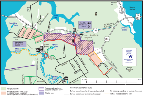
Upper and Lower Creef Units
The Upper Creef Unit lies east of Milltail Road and north of Link Road and includes Gadwall, Bobcat, Creef, Sprigtail, and Peterson Roads. The Upper Creef Unit is closed to all public entry through the end of February to provide sanctuary for wintering waterfowl.
The Lower Creef unit is located between Link, Bear, Borrow Pit, and Long Curve Roads.
Link Road and the northwest portion of Bear Road are currently open to foot traffic only from 9am to dusk (1/2h after sunset). The area is closed to all entry between dusk and 9am.
There is currently no stopping, standing, or parking on Grouse Road, the southeast portion of Bear Road, and the portion of Long Curve Road between Milltail Road and Link Road. While observing wildlife on these sections of road, do not stop, get out of your vehicle, or linger in one area.
These restrictions are necessary due to growing visitation pressure on both red wolves and black bears in this area. Some visitor behaviors change wildlife behaviors and lead to an unnatural comfort level of red wolves and bears around people and vehicles. These behaviors include closely approaching wildlife, following wildlife, and remaining in one spot for long duration. When humans and vehicles remain in one place for long periods of time, animals are unable to use the area without human presence. Human presence can prevent animals from using important foraging habitat and can force animals into close contact with humans, increasing the risk of habituation.
Human habituation, or acclimating to the presence of people, reduces wildlife’s normal elusiveness and fear responses. Instead of avoiding areas of human activity and fleeing at the sight of people, the animals may choose to approach or remain closer than is natural. Acclimating to people may increase the likelihood of incidents that are detrimental to their survival, such as the vehicle strike mortality of red wolf 2323, the breeding male of the Milltail red wolf pack.
Please be mindful of your behaviors and actions at all times when on the refuge. On a National Wildlife Refuge, the welfare of plants and animals and their habitats come first. Follow these viewing guidelines:
- Use binoculars or a zoom lens to view wildlife from a distance—at least 100 yards or eight school buses.
- If wildlife approaches you, move back to stay 100 yards away.
- If animals react to your presence, you are too close.
- Don’t remain in one spot for a long time, so that wildlife has time to use that area without human presence.
- It’s illegal to feed, touch, tease, frighten, or intentionally disturb wildlife.
Be careful when driving to protect wildlife as well. Be sure to always follow the speed limits and watch for wildlife that may dart into the road. When you want to stop to watch wildlife, pull your vehicle to the side of the road, do not block traffic, and move on once you've had a good look.
Red Wolf Recovery Program staff will be continually monitoring red wolf activity in the area of the closures throughout this time period. The most reliable source for current information about red wolves is the Red Wolf Recovery Program website.
Twiford Unit
The Twiford Unit is the area between Milltail and Buffalo City Roads and north of Sawyer Lake Road. The Twiford Unit is currently closed to all entry through the end of February to provide sanctuary for wintering waterfowl. Sawyer Lake Road is open to motorized vehicles.
Laurel Bay Unit
The Laurel Bay Unit is the area west of Buffalo City Road and east of Pump Road. River Road, Pump Road, and Laurel Bay Road between River and Pump Roads are currently open to motorized vehicles. Other roads in the Laurel Bay Unit are open to foot traffic and bicycles through the end of January.
Buffalo City Road
High water levels or heavy rainfall may lead to flooding at the end of Buffalo City Road. When flooding is present, please turn around before the end and do not drive in standing water.
Grassy Patch and Dry Ridge Roads
Grassy Patch and Dry Ridge Roads are currently closed to all public entry for management activities.
Chip Rd
Chip Road is currently closed to all public entry for management activities.
Canvasback Rd
Canvasback Road is currently closed to all public entry for management activities.