

Visit Us
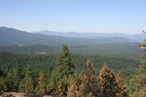
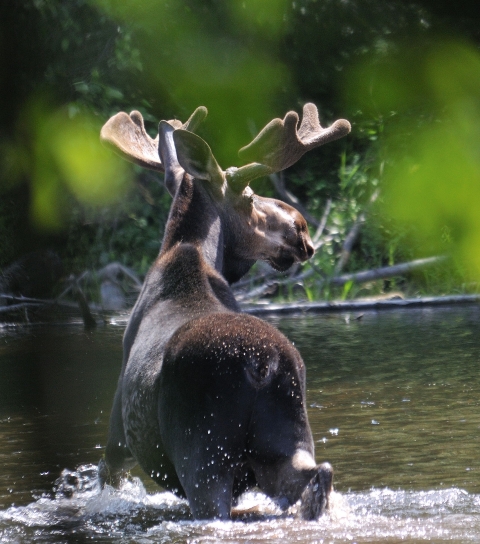
National Wildlife Refuges offer us all a chance to unplug from the stresses of daily life and reconnect with our natural surroundings. Little Pend Oreille National Wildlife Refuge offers ample natural areas to experience, from scattered meadows and old fields, to lakes and rivers that dot our landscape. We are also the only mountainous, mixed conifer forest refuge in the lower 48 states, and provide opportunities to see unique mountainous wildlife species.
Fees
There is no charge to visit the refuge.
Restrooms
Restrooms are available:
- Inside Refuge headquarters/Visitor contact station
- Comfort station in headquarters parking lot, Horse Camp, River Camp, Bear Creek Camp, Potter's Pond, Bayley Lake and McDowell Lake Overlook
Points Of Interest
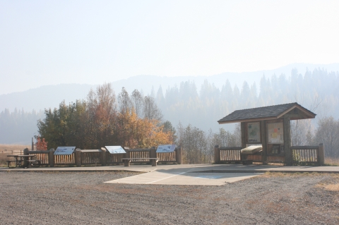
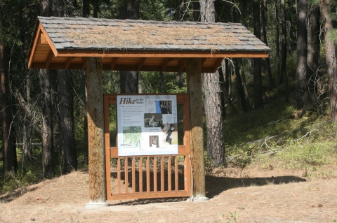
Let our staff and volunteers at the visitor center help you plan your visit! This is a great place to start. We are happy to orient you to the refuge and the wildlife that lives here.
Begin your visit at the entrance kiosk adjacent to refuge headquarters. There you can touch a 3-dimensional map the refuge, and read about some of the history and wildlife that makes this refuge unique. Brochures are available describing refuge activities and rules, and include a foldout map to help you navigate during your visit. Some points of interest include the Sampson log barn, the oldest structure remaining from the homestead period, Potter’s Pond for a chance to view waterfowl, and interpretive exhibits along the McDowell Marsh Environmental Education Trail and the auto tour.
What To Do
If you have 15-minutes.
- If you only have 15-minutes, visit the visitor kiosk next to refuge headquarters and hike the short trail to view the nearby Little Pend Oreille River and the more distant Calispell Peak.
If you have one or two hours.
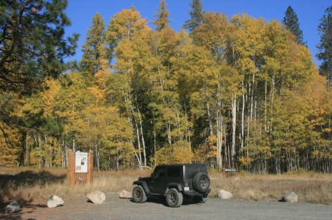
- In one hour, you can drive the auto tour and learn about the habitats, wildlife, and history of the refuge.
If you have half a day or more.
- Several hiking trails are available, and you’re welcome to walk or bicycle any of the roads closed to motorized vehicles. The various habitats provides opportunities to view a wide variety of birds. Fish one of the refuge’s three lakes or the Little Pend Oreille River (be sure to check the regulations!). You can even spend a night or two in one of the refuge’s campgrounds. In the winter, cross-country ski or snowshoe on the closed roads.
Know Before You Go
Bring plenty of drinking water, snacks, insect repellant, sunscreen, and other necessities. Dress appropriately for the seasons and wear comfortable walking shoes.
Visitor Tips
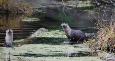
Refuge lakes and marshes provide a spring and fall stopover point for migratory waterfowl. Wildlife viewing requires patience and quiet. Best viewing is typically dawn and dusk. Transition zones between habitats like forest and field or field and river have the greatest diversity of birds and mammals. Areas around lakes, ponds and creeks are also good spots to observe wildlife.
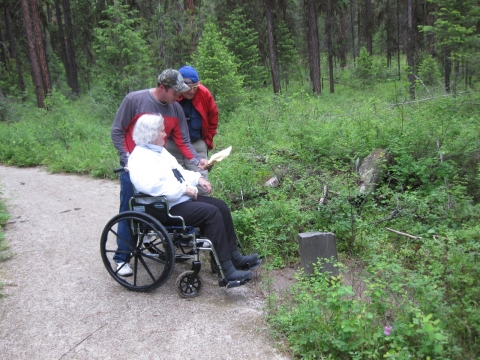
Our new 11 mile long Auto Tour starts at Refuge headquarters with a new welcome and information sign at the visitor kiosk. There are twelve interpretive stops with illustrated panels using color photos and drawings or historic black and white photos. Learn about the early homesteaders, railroad logging, unique habitats and past and current management practices. Several sites offer wildlife viewing opportunities as well as access for the mobility impaired. The route is open for driving from April 15 through December 31.
Activities
Wildlife orientated recreational activities abound at Little Pend Oreille National Wildlife Refuge.
Related Documents

Other Facilities in the Complex
The Inland Northwest National Wildlife Refuge Complex comprises three refuges - Little Pend Oreille and Turnbull Refuges in northeast Washington and Kootenai Refuge in northern Idaho. We share work priorities, budgets and some staff. Turnbull Refuge is the complex headquarters.
Despite common management oversight, each of the three complex refuges is unique. Little Pend Oreille, at 42,657 acres, is a mountainous forested Refuge with clear streams, scattered lakes, and diverse outdoor pursuits; Turnbull, at 18,217 acres, features over 130 wetlands, ponderosa pine forest, steppe grassland, aspen, and rock set in a distinctive landscape that offers many possibilities for experiencing nature; Kootenai, at 2,774 acres, is a small gem of diverse wetland, cropland, and upland habitats and recreational opportunities.


Rules and Policies
Vehicles
- The Refuge is closed to all unauthorized vehicle traffic from January 1 through April 14. Roads open year round are Bear Creek Road from our west boundary to Refuge Headquarters, Buffalo-Wilson Road and Narcisse Creek Road.
- All state traffic laws apply on Refuge roads; the speed limit on Refuge roads is 25 miles per hour. Vehicles operating on Refuge roads must be street legal with current registration, have mufflers, license plates and be in proper operating condition.
- Vehicles must remain on established roads open to the public. You may park vehicles along roadsides but do not block any roads, gates or trails.
- Some roads are signed "Authorized Vehicles Only" and closed to unauthorized motorized vehicle travel to protect wildlife habitat, provide seclusion for wildlife and reduce road maintenance costs. Non motorized travel is allowed.
- ATV, ORV and UTV use is prohibited on all Refuge lands. Snowmobiles are only allowed on Olson Creek Road and the Flodell Snow Park parking area.
- Bicycles are only allowed on maintained roads including those closed to motorized vehicles.
Hunting
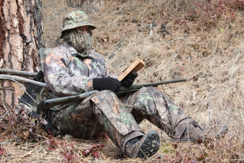
Spring
The Refuge is open for Spring turkey hunting, including the youth season, in accordance with Washington Department of Fish and Wildlife regulations. No other spring hunting including bear hunting is allowed.
Fall/Winter
Hunting is allowed for all species from September 1 through December 31 in accordance with Washington Department of Fish and Wildlife regulations. Although beginning in 2019 the state's black bear hunting season opens on August 1, no hunting of any kind is allowed on the refuge, including black bear, until September 1. The Refuge is closed to all pursuit and hunting of game or discharge of firearms at all other times. The majority of the Refuge is in Washington Department of Fish and Wildlife Game Management Unit 117.
Deer
There is a 3 point minimum on mule deer and any white-tailed buck may be hunted. The 4 point minimum has been eliminated.
Waterfowl
Waterfowl hunting is allowed on Refuge lakes and ponds but all streams are closed to waterfowl hunting. Steel shot must be used for waterfowl hunting.
General Regulations
- Loaded rifles and shotguns in a vehicle and target shooting are prohibited.
- The possession or use of alcoholic beverages while hunting is prohibited.
- Distributing or hunting over bait and spotlighting (including using vehicle headlights) is prohibited.
- The use of dogs for hunting is allowed for legal bird hunting only. Dogs are not allowed to roam at large and must be under control at all times.
- All federal and State of Washington hunting regulations, seasons, bag limits and license requirements apply. See the Washington Department of Fish and Wildlife's Hunting Seasons and Rules brochures for more information.
Shelter and Stand Regulations
- Portable or temporary blinds and tree stands must be removed after three days.
- Permanent blinds and pits are not allowed.
- Do not use spikes, nails, screws, bolts or wire to secure blinds or stands to trees.
Firearm Regulations
- Discharging of firearms is prohibited except when legally hunting.
- Do not shoot a firearm within one quarter mile of any maintained building or designated campground.
- The area around McDowell Marsh is closed to hunting to protect visitors using the McDowell Marsh Environmental Education Trail.
- Loaded rifles and shotguns in a vehicle and target shooting are prohibited.
- Possession or use of other weapons like cross bows, bows and arrows, air guns, spears or gigs is prohibited unless legally hunting.
Hiking
Bicycles, horses and motorized vehicles are not allowed on hiking trails, including the McDowell Marsh Environmental Education Trail.
All areas of the Refuge are open to hiking unless posted otherwise.
Camping
Camping is allowed only in designated campgrounds that have metal fire rings from April 15 through December 31. There is a 7 day camping limit within a 30 day consecutive period for all designated campgrounds from April 14 through September 30.
Dispersed campsites are open from September 1 through December 31. These campsites must be within 50 feet of a dispersed campsite marker - a brown carsonite post. There is a 14 day camping limit within a 30 day consecutive period for all designated campgrounds and dispersed campsites from October 1 through December 31. At these dispersed sites, all solid human waste must be buried in a hole 6 to 8 inches deep and at least 200 feet from camp, water or trails.
Camping Regulations
- Do not leave campfires unattended.
- No drinkable water is available on the Refuge.
- Remove all garbage and trash- do not burn it in your campfire.
- Do not leave food outside overnight and do not feed wild animals.
- A special permit is required for all activities involving groups exceeding 25 persons or 10 horses.
Firewood
Firewood cutting for off Refuge use is allowed by special use permit and is for personal use only. Permits are available at Refuge headquarters during office hours and cutting is only allowed from July 15 through October 31. Firewood cutting permits can be obtained by contacting refuge headquarters.
You may cut firewood for use in designated campgrounds and dispersed campsites. Any firewood not used while camping may not be taken off the Refuge unless you have a special use permit. Use only dead and down trees for firewood - do not cut down snags. Cutting, defacing or damaging live trees is prohibited.
Fishing
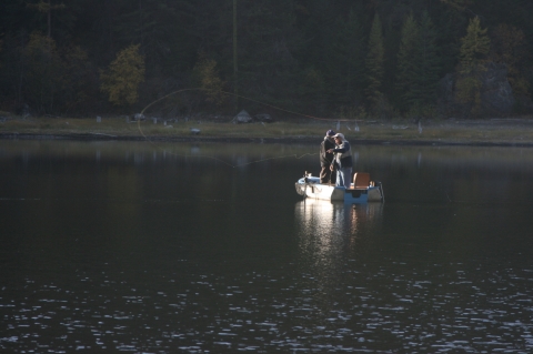
Fishing is allowed in Refuge lakes from the last Saturday in April through October 31; in the Little Pend Oreille River, the Rookery Road beaver ponds and all other streams from the Saturday before Memorial Day through October 31.
Bayley Lake
(17-72 acres) is a fly-fishing only lake, catch and release for the entire season. The inlet to Bayley Lake is closed to fishing. It has public access with high and low water boat launches.
McDowell Lake
(47 acres) is a fly-fishing only lake, catch and release for the entire season. It has public walk-in access for boat launches. This lake has been treated to eliminate Tench (a undesirable non-native fish). Please report any Tench caught on the angler report forms available at the launch sites. The Washington Department of Fish and Wildlife monitors the fishing effort and harvest at Bayley and McDowell Lakes. Please complete a survey form to help us measure fishing success.
Potter's Pond
(15 acres) has an accessible fishing dock, parking and restroom.
All federal and State of Washington fishing regulations, seasons, limits and license requirements apply. See the Washington Department of Fish and Wildlife's Fishing in Washington brochure for more information.
Boats
Non-motorized boats may be used on all Refuge lakes and ponds; electric powered motors are only allowed on Potter's Pond.
Horses
Horseback riding is only allowed on maintained roads and horse trails. Horses are not allowed on most hiking trails including the McDowell Marsh Environmental Education Trail.
Camping with horses is only allowed in Bear Creek and Horse Camps. Horses cannot be tied directly to trees. Horses in campgrounds must be confined by hitch rails, tied to a high picket line or confined in portable corrals that are at least 100 feet from streams or bodies of water.
Visitors must provide food for their horses. Remove all trash, garbage, horse manure and excess straw and hay - do not burn it in your campfire. A special permit is required for all activities involving groups exceeding 25 persons or 10 horses. Special Use Permits can be obtained by contacting refuge headquarters.
Pets
Pets are not allowed to roam freely and must be under control at all times.
Locations
Little Pend Oreille National Wildlife Refuge is 13 miles southeast of Colville, Washington in the northeast corner of the state.
From Colville, Washington
From Main Street (Highway 395) in Colville, follow Third Avenue (Highway 20) for 6 miles – you will be traveling east toward Tiger, WA. Just after passing White Mud Lake, make a right turn onto Artman-Gibson Road. The sign states the Refuge is 7 miles away. Travel 1.7 miles until reaching a 4-way intersection. Turn left onto Kitt-Narcisse Road and follow it for 2.2 miles where the road forks. Take the right fork onto Bear Creek Road (a dirt road), and follow it for 3.3 miles. The Refuge headquarters is a brown log building.
From Spokane, Washington
Follow Highway 395 north. You can either drive all the way to Colville and follow the above directions, or exit the highway in Arden (about 6 miles south of Colville). From Arden, make a right turn off the highway at Hall Road (just past a lumber mill on the left). At the stop sign, turn left onto the Old Arden Highway and travel a short distance. At the third right, turn onto Artman-Gibson Road and follow it for approximately 4 miles until reaching a 4-way intersection. Turn right onto Kitt-Narcisse Road and follow it for 2.2 miles where the road forks. Take the right fork onto Bear Creek Road (a dirt road), and follow it for 3.3 miles. The Refuge headquarters is a brown log building.
From Newport, Washington
Follow Highway 20 to Tiger, WA and continue on Highway 20 to where it intersects with Artman-Gibson Road (about 30 miles). turn left onto Artman-Gibson Road. The sign states the Refuge is 7 miles away. Travel 1.7 miles until reaching a 4-way intersection. Turn left onto Kitt-Narcisse Road and follow it for 2.2 miles where the road forks. Take the right fork onto Bear Creek Road (a dirt road), and follow it for 3.3 miles. The Refuge headquarters is a brown log building.
From British Columbia, Canada
Travel to Metaline Falls, Washington from Route 6 in BC changing to Highway 31 in Washington. Continue to Tiger, WA and turn right on Highway 20. Continue on Highway 20 to where it intersects with Artman-Gibson Road (about 30 miles). Turn left onto Artman-Gibson Road. The sign states the Refuge is 7 miles away. Travel 1.7 miles until reaching a 4-way intersection. Turn left onto Kitt-Narcisse Road and follow it for 2.2 miles where the road forks. Take the right fork onto Bear Creek Road (a dirt road), and follow it for 3.3 miles. The Refuge headquarters is a brown log building.
Or travel to Northport, Washington from Route 22 or 22A in BC to Highway 25 in Washington. Continue on Highway 25 to Kettle Falls, WA. Turn left onto Highway 395 to Colville, WA. From Main Street (Highway 395) in Colville, turn left on Third Avenue (Highway 20) for 6 miles – you will be traveling east toward Tiger, WA. Just after passing White Mud Lake, make a right turn onto Artman-Gibson Road. The sign states the Refuge is 7 miles away. Travel 1.7 miles until reaching a 4-way intersection. Turn left onto Kitt-Narcisse Road and follow it for 2.2 miles where the road forks. Take the right fork onto Bear Creek Road (a dirt road), and follow it for 3.3 miles. The Refuge headquarters is a brown log building.