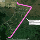
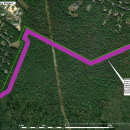
Cape May NWR is undertaking a fuels reduction project along select potions of the Refuge boundary. The purpose of the project is to reduce the potential of a wildfire burning off the Refuge and onto adjacent lands. These areas will provide firefighters with a tactical advantage by reducing expected fire behavior. It will also aid in limiting the spread of fires onto Refuge lands. The work will commence in two areas: in Dennis Township along the Refuge boundary in the area Buck Drive north to Woodbine Ocean View Road; and in Upper Township along the Refuge boundary from the area of Wexton Drive north and east to the area of Mockingbird Lane. The project entails to mastication of highly flammable shrub species and trees less than or equal to 4” in diameter in a 100-foot-wide swath. The project is offset from private property to minimize disturbance and impacts to our neighbors.
Habitat management, Resilience and risk mitigation