


About this Collection
Field Reports from the 2026 Waterfowl Breeding Population and Habitat Survey
Mark Koneff, Chief, Branch of Migratory Bird Surveys, USFWS
Another spring has come and gone and another Waterfowl Breeding Population and Habitat Survey (WBPHS or Survey) is in the bag. As always, I feel a great sense of gratitude to all the pilot-biologists, waterfowl scientists, and analysts that cooperate to pull off such a giant undertaking each year—and an even greater sense of gratitude when all crews return home safely.
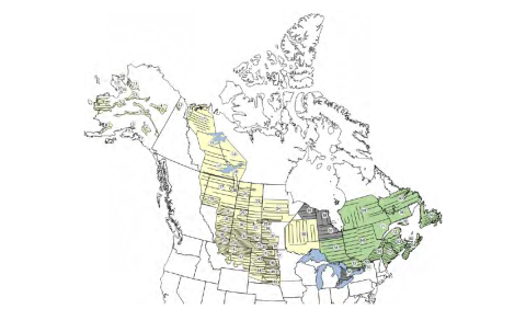
The WBPHS is composed of two survey areas, the Traditional Survey Area (TSA; yellow shaded) and the Eastern Survey Area (ESA; green and gray shaded). Much of the TSA has been continuously surveyed since 1955, while surveys in the ESA began in 1990. The numbered regions of the survey map are strata. We partition the strata into 11 crew areas so we can divide and conquer and complete the survey within a relatively narrow biological window during the waterfowl breeding season. The Survey’s 70-year history, geographic scope, international cooperation, significance to the management of waterfowl and maintenance of the waterfowling heritage, and contribution to the general scientific knowledge of migratory wildlife populations are unique. Many waterfowl populations in North America are highly dynamic and respond to both short-term, interannual variation in habitat conditions from year-to-year variability in weather and to long-term changes affected by agricultural practices, forestry or industrial impacts, other development, climate patterns, governmental policies, world markets, and conservation activities. Because the WBPHS has been conducted every year for a long time, it helps managers understand how waterfowl populations respond to hunting and conservation efforts, while accounting for both short‑term and long‑term environmental changes happening at the same time.
In 2026, spring was delayed across much of the survey area. Survey crews, accordingly, delayed the start of the WBPHS in many areas to try to match survey timing to the desired interval during the breeding period. Overall, habitat conditions were mixed across the U.S. and Canadian prairie pothole region. Dry conditions persisted in Montana and the western Dakotas and the southern grasslands of Alberta, Saskatchewan, and Manitoba. Conditions across the Canadian Prairie Provinces improved to the north. In the U.S. prairies, South Dakota was generally dry with conditions reported as poor to fair in most areas. Wetland conditions improved some in North Dakota especially in the important Missouri Coteau Region. The southern boreal forest of central Canada received substantial winter precipitation which helped break the abnormally dry conditions that have persisted there for the past several years, also bringing some welcome relief from recent extreme wildfire seasons. While spring phenology was also delayed in Alaska and the boreal forest and barrenlands of eastern Canada and Maine, wetland conditions were generally good. Delayed spring phenology and associated cold, wet, windy conditions may impact waterfowl production locally.
Select the links below for more information and photos of conditions as reported by the field crews…