ABOUT WALK FOR THE WILD
Did you know that humans spend 95% of their time indoors? We’re becoming more and more of an indoor species.
A growing body of evidence supports the idea that spending time in nature promotes mental and physical well-being. We all need a little more of that, right?
This October – to celebrate National Wildlife Refuge Week – join us to help wildlife and humans to thrive by taking a walk, stroll, saunter, hike, prance, trot, amble, ramble or roll for the wild.
How to Participate
Check out our trail maps, recommended self-guided 5Ks below or join a guided event.
Move a distance of 5k (3.1 miles) in nature during the week starting October 8, 2022. It’s up to you how you move (as long as you do it self-propelled), where in nature you go, and whether you go solo or with friends or family.
During the week, record your activity — walking, jogging, hiking, strolling, or whatever you choose— either manually, or using your favorite fitness tracker. Once you’ve completed the 5k distance (3.1 miles), you are officially a Finisher! Visit one of our visitor centers for your FREE finisher sticker*! *while supplies last
- Lastly, we hope you share your challenge experiences on social media by tagging us @MNvalleyNWR on Facebook and using the hashtags #WalkForTheWild and #WildlifeRefuges
RECOMMENDED 5Ks AT MINNESOTA VALLEY NATIONAL WILDLIFE REFUGE
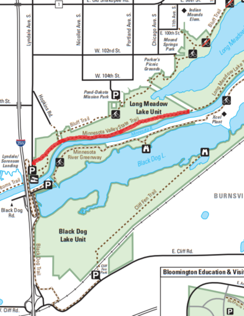
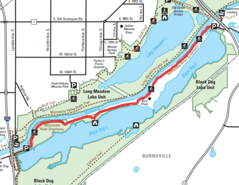
| Minnesota Valley State Trail - Bloomington | Minnesota River Greenway | Long Meadow Lake Trail to Old Cedar Bridge |
|---|---|---|
|
|
|

Or find another trail, visit our Trails section.
JOIN OUR GUIDED WALKS
Birdwatching Treks
Join refuge naturalist Craig Mandel for a bird walk and learn about the birds that visit the Minnesota Valley National Wildlife Refuge during their fall migration.
- Old Cedar Ave - 9551 Old Cedar Ave S, Bloomington, 55425 MN
- Saturday, October 8 at 8-10:30 a.m.
- For more information click here.
- Bass Ponds - 2501 86th St. E., Bloomington, MN 55425
- Sunday, October 16 at 8-10:30 a.m.
A Bridge to the Past: Exploring the History of the Old Cedar Avenue Bridge
The pedestrian bridge at Old Cedar Ave is a great place to watch for wildlife, but it also holds a long history of connecting communities, earning the bridge a spot of the National Register of Historic Places. Learn about this history on a short walk across the paved bridge and back again.
- Old Cedar Ave Bridge - 9551 Old Cedar Ave S, Bloomington, MN 55425
- Thursday, October 13 - 6:00 p.m. - 7:00 p.m.
- Saturday, October 15 11:00 a.m. - 12:00 p.m.
Ranger Walk: Sizing Up Bur Oaks
Have you ever wondered how big a tree is when you see them in a forest or in your back yard? Learn how to measure a tree with a few simple tools you already have at home.
- 15865 Rapids Lake Rd, Carver, MN 55315
- Thursday, October 13 - 2:00 p.m. - 2:30 p.m.