Location
States
TexasEcosystem
Coastal, WetlandIntroduction
The Gulf Coast region of Southeast Texas is known for its coastal wetlands, agriculture, and urban centers. Brazoria is a coastal county south of Houston, Texas. In the early 1900s, multiple damaging floods led to the establishment of the Danbury Drainage District and the construction of a series of ditches to reduce flood risks and support agricultural operations in the watershed.
Brazoria County has extensive coastal habitats that support many bird species, including wintering waterfowl. In 1966, about 6,300 acres of habitat was acquired through the establishment of Brazoria National Wildlife Refuge (NWR). Brazoria NWR protects wetland ecosystems like salt marshes, freshwater swamps, and coastal upland prairies that provide habitats for over 320 bird species and 95 herpetological species.
However, the ditches established by the Danbury Drainage District within the refuge remain under the Drainage District’s management to maintain flood prevention structures and support the cultivation of 1,200 acres of rice fields. While these goals have been accomplished, the ditch system has also diverted surface water off of refuge land and its wetlands. These wetlands have become drier and receive less sediment and nutrients, resulting in degraded habitats for fish and wildlife resources.
To restore Brazoria NWR’s native wetlands, the refuge began collaborating with Ducks Unlimited in 2014 to assess site conditions. The Texas coastal plain, including this area of the refuge, is relatively flat with slight variation in elevations. This finding revealed a need for hydrologic modeling to understand how water was moving through the site and the ditch network located in a roughly 9,200 acre section of the refuge called the Chocolate Bay Prairie Unit (CBPU). Using this model to evaluate the best alternative structures, Brazoria NWR partnered with Ducks Unlimited and the Drainage District to develop a plan to restructure the ditch network in a way that supported the refuge’s restoration goals while keeping properties upstream of the refuge safe from floods. Increasing hydrologic connectivity to support ecological restoration as well as human infrastructure is an example of nature-based solutions that address societal challenges through ecosystem-based actions, providing benefits for both people and nature.
Key Issues Addressed
Ditches streamline drainage, moving surface water off the land quickly and decreasing the time water resides on the landscape. As a result, the hydroperiod, or number of days water remains on the landscape, decreases, making the wetland areas drier. This inability to retain surface water is especially concerning for wetlands at Brazoria NWR since little groundwater permeates through its primarily clay soil. Additionally, the water quality is reduced as it drains directly from the ditches into Chocolate Bay without passing through the vegetated wetlands.
Although restoration of the original topography may be ecologically beneficial, filling in the ditches would flood upstream communities and properties. According to Risk Factor’s 30-year prediction based on current trends of climate change climate change
Climate change includes both global warming driven by human-induced emissions of greenhouse gases and the resulting large-scale shifts in weather patterns. Though there have been previous periods of climatic change, since the mid-20th century humans have had an unprecedented impact on Earth's climate system and caused change on a global scale.
Learn more about climate change , Brazoria County is at a “severe” risk of flood damage while its commercial areas face an “extreme” risk– the two highest classifications.A complete lack of water management infrastructure would also threaten businesses that rely on agriculture production.
Project Goals
- Restore a portion of historic wetland flows by increasing the length of the hydroperiod in Brazoria NWR wetlands: This will restore native wetland habitats and improve water quality for the benefit of local fish and wildlife species.
- Maintain flood safeguards to protect Brazoria County residents, businesses, and agriculture.
- Develop a restoration implementation plan that is beneficial and manageable for Brazoria NWR and the Drainage District.
Project Highlights
- Applying Surface Water Flow Modeling to Wetland Conservation: To increase the refuge’s hydroperiod, partners evaluated alternative structures to the current ditch network. To determine what would best benefit the wetland, they needed to first understand how water moved on the landscape. Partners at the consulting group Freese & Nichols helped during this stage by providing expert assistance with flood modeling. Light Detection and Ranging (LiDAR) mapping, combined with Real Time Kinematic (RTK) surveys, predicted how flow patterns and volumes vary within the current landscape. These instruments were also used to model several alternative actions that would restore water flow on refuge wetlands. The alternative actions included removal and installation of structures such as berms and weirs, placed at different locations. Use of this modeling provided quantities and visuals that could be easily evaluated by the project partners.
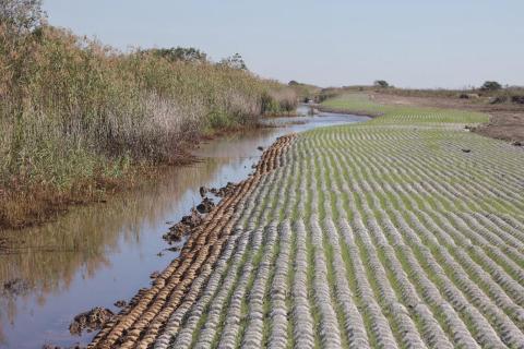
- Redirecting Drainage: After considering the environmental impacts demonstrated by the modeling results, ease of maintenance, and cost efficiency, they decided to fill in parts of the ditch network while installing and altering the placement of several berms and weirs. Berms are small levees constructed with soil taken from previous water management activities. These new berms will divert rainfall runoff back into the natural wetland channels and eventually into Wharton Bayou, a small estuarine marsh system. The levees will also support vehicular access to maintain and repair the ditches in addition to serving as the main access route used by refuge staff to manage the 9,200- acre tract. Weirs are lower elevation structures that allow water to flow across their top while protecting the substrate from erosion. Two major wetland sloughs (swamps) are bisected by Ditch 1, a main conveyance for rainfall runoff into Chocolate Bay. Each of these sloughs will have a weir to accommodate upstream flows through them. These specific weirs were also designed to support additional vehicular transportation during drier periods. With the help of their partners, Brazoria NWR completed construction in October 2024.
- Establishing Trust and Cooperating with Partners: USFWS staff promoted collaboration and trust by ensuring that Drainage District engineers participated in reviewing the modeling results and planning meetings. Through the partnership of the USFWS, Drainage District, Ducks Unlimited, Freese & Nichols, and other stakeholders, the group was able to ensure that the needs of the community and wildlife resources were met.
Lessons Learned
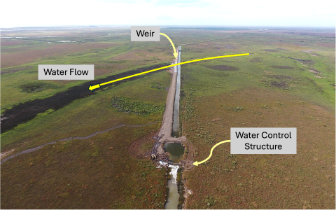
Changes to the ditch network are not expected to increase flood risk for the local community. Additionally, all the implemented features will be completely passive, requiring minimal operation and maintenance except for the water level control feature in Ditch 1. This structure is required to raise water levels in Ditch 1 such that water can flow over the weir structures and into the wetland sloughs and eventually into Wharton Bayou.
Brazoria NWR’s flat topography made it difficult to identify how surface water was moving on the land. By combining LiDAR and a flood assessment model, the team was able to understand existing conditions, evaluate alternative design features, and optimize a suite of actions that will accommodate future environmental changes such as sea level rise and periods of drought or extreme precipitation.
Balancing both human and environmental concerns can pose challenges. The Drainage District was established to support agriculture and protect the community from flooding. Meanwhile, Brazoria NWR was established to conserve habitats for fish and wildlife. Because of these different missions, each organization prioritized different objectives. An initial step that supports change is understanding each organization’s needs. Knowing each other’s needs can reveal alternatives that previously would not have been considered by either organization. Therefore, it was critical for USFWS staff to understand and respect the needs of the district. Incorporating those needs into a strategy to develop a nature-based solution helped identify the information needs, possible alternatives, and ultimately a final design for the project. The resulting plan will not only prevent increased flooding, but may actually reduce flood risk to upstream communities.
Next Steps
- Now that construction is completed, the project team will implement the post-construction monitoring plan to assess project performance.
- Evaluate the results of the monitoring and reconvene the project partners to determine if any adaptive management actions are needed.
- Explore ways to communicate this project’s importance to a general audience: Because hydrologic improvements do not yield obvious changes in scenery that can be shared immediately, it will be difficult to demonstrate the positive impact these implementations will have on ecological resources. However, monitoring water flows and water levels can reveal the benefits to the upstream community.
Funding Partner
- Gulf Environmental Benefit Fund (National Fish and Wildlife Foundation)
- North American Wetlands Conservation Act
Resources
- “Does Brazoria County Have Flood Risk?” Flood Risk.
Contacts
- Kevin Hartke, Ducks Unlimited: khartke@ducks.org
- Jennifer Wilson, USFWS: jennifer_wilson@fws.gov
- James Dingee, USFWS: cody_dingee@fws.gov
- Woody Woodrow, USFWS: Woody_Woodrow@fws.gov
CART Lead Author
- Alyssa Wood, Student Case Study Author, University of Arizona
Suggested Citation
Wood, A.G. (2025). “Modeling Hydrologic Alternatives for Wetland Restoration on Brazoria National Wildlife Refuge.” CART. Retrieved from https://www.fws.gov/project/nature-based-solutions-hydrologic-alternatives-wetlands.