Location
States
CaliforniaEcosystem
DesertIntroduction
In the 1980s, in response to a growing human population and burgeoning land development, conservationists, politicians, and land developers in the Coachella Valley worked together to protect the threatened Coachella Valley fringe-toed lizard while ensuring continued economic development. The result was a 18,765-acre Habitat Conservation Plan (HCP). In the 1990s, stakeholders worked together to develop a more inclusive Multiple Species HCP (MSHCP) and improve habitat protection for the lizard while also providing Endangered Species Act (ESA) coverage for 27 species, including those that were federally listed at the time or may become listed in the future. Approved in 2008, the MSHCP encompassed over 700,000 acres, conserving an additional 240,000 acres of open space and protecting habitat for 27 species.
HCPs (or MSHCPs) are mechanisms allowed under the Endangered Species Act (ESA) to permit incidental losses to listed wildlife, plants, and their habitats (“incidental take”) that occur during development, as long as sufficient habitat receives permanent protection to ensure that those plant and wildlife populations are sustainable. Typically, regional land use authorities, such as cities, counties, or large landowners, adopt HCPs as a means of balancing ESA compliance with economic development. HCPs are required as part of an application for an incidental take permit. The federal agency charged with overseeing ESA compliance is the US Fish and Wildlife Service (FWS). HCPs are developed by permittees, but FWS can provide technical support. In issuing incidental take permits, FWS complies with the requirements of the National Environmental Policy Act (NEPA) and all other statutes and regulations. An HCP must include: 1) biological goals and objectives for each species covered by the HCP, 2) adaptive management, 3) monitoring, 4) a permit duration designed to provide the time needed to achieve goals and objectives, and 5) public participation. A HCP serves as a single FWS permit to comply with ESA for all areas and species included in the plan.
Key Issues Addressed
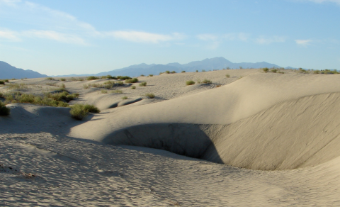
The Coachella Valley has been one of the fastest growing regions of the United States. This includes population growth and land development for agriculture, residences, and industry. The original HCP left out some lands that were critical to maintaining the lizard’s dune habitat. Two sand transport corridors, where sand movement by wind and water maintain the dunes that comprise the lizard’s habitat, were threatened by development of multiple golf courses and several thousand residences. Preserving these key ecosystem processes while incorporating several additional species and expanding the plan area was a major motivation for developing the MSHCP.
The Coachella Valley was once covered by 100 square miles of sand dunes. By 1980, up to 95% of the Coachella Valley’s sand dunes were developed. The remaining dunes were fragmented and in some cases disconnected from their sand source. Although critical ecosystem processes that replenished sand dunes as they lost sand downwind were considered during the development of the initial HCP, the high cost associated with acquiring all sand transport areas led to the decision to not include two that were not expected to be developed. However, development proposals were later put forth that would have blocked sand replenishment by cutting off corridors between dunes and sources of new sand. Without sand replenishment, existing dunes would eventually blow beyond the boundaries of conservation lands and stabilize. When sand dunes stabilize, they no longer provide sufficient habitat for fringe-toed lizards and other dune species. A conservation design was needed that facilitated the dynamic nature of the dune system by incorporating ecosystem processes at multiple spatial and temporal scales to support biodiversity and allow species to adapt to changing conditions.
Project Goals
- Develop a MSHCP that expands the HCP to encompass ecosystem processes and fulfill the requirements of the ESA on a larger scale, with more species and a larger area
- Work with stakeholders across sectors to collaboratively develop the MSHCP
Project Highlights
An ESA First: The 1986 Habitat Conservation Plan was the first large-scale, regional HCP developed after a 1982 amendment authorizing them as a mechanism for complying with the Endangered Species Act.
- Incorporating Ecosystem Processes: Partners adopted an ecosystem framework to design and develop the MSHCP, wherein the preservation of lands where key ecosystem processes were still intact were recognized as being crucial to the success of the plan. This meant that some lands where the lizards and other target species didn’t occur still needed to be included in the plan in order to protect the processes sustaining their habitats. The ecosystem framework allowed for the development of clear and objective criteria for deciding what lands needed to be acquired for preservation and where restrictions on land use were needed.
- Monitoring Environmental Variables: Applying an ecosystem framework meant that monitoring to determine the success of the plan needed to go beyond counting individuals of the target species. A monitoring framework was designed to determine what factors besides conservation design could be influencing species counts, such as weather, climate, sand characteristics, fragmentation, invasive species invasive species
An invasive species is any plant or animal that has spread or been introduced into a new area where they are, or could, cause harm to the environment, economy, or human, animal, or plant health. Their unwelcome presence can destroy ecosystems and cost millions of dollars.
Learn more about invasive species , and interactions among species. As such, monitoring was designed to identify the causes affecting the population changes of the target species and inform adaptive management. Monitoring was also designed to address multiple scales: species-level, landscape-level, and natural community-level. - Administration and Management: The Coachella Valley Association of Governments (CVAG), a joint powers authority encompassing each of the cities and the portion of Riverside County within the Coachella Valley, administers the MSHCP through a committee comprised of elected officials, the Coachella Valley Conservation Commission (CVCC). The CVCC created additional committees, including federal and state regulatory agencies and all landowners to oversee management and acquisition of lands covered under the plan. The CVCC administers contracts to purchase conservation lands and to implement biological monitoring. Funding was pooled from all partners and from permitting fees.
Lessons Learned

Doing mitigation and conservation on a project-by-project basis risks leaving out the ecosystem processes that regulate habitat for target species. HCPs (and MSHCPs) are a mechanism by which processes can be preserved, and fragmentation can be minimized.
Stakeholders understood that without protecting the ecosystem processes regulating habitat for species, sustaining wildlife populations was not going to be possible in the longer-term, even if areas where the species occur were protected. Using the ecosystem framework allowed for the development of objective criteria for deciding, with minimal disagreement, which lands to acquire and where different land uses would be allowed. The incentive for developers and local governments to put time and effort into developing a plan was the identification of lands that could not feasibly be used for conservation. In these areas, permitting for development would be streamlined and simplified.
Efforts to include key sand corridors in the MSHCP that were left out in the HCP have so far been successful is supporting the fringe-toed lizard. Populations are being maintained, which is a positive outcome considering that the region is in its 7th or 8th year of unprecedented drought (as of Dec 2018). Lizards are no longer present in undeveloped dunes that were cut off from key sand transport processes.
The MSHCP has been successful, showing that conservation and economic development can co-occur. There is a clear plan for preserving 27 species. Cities, counties, and developers see the value of it as it creates certainty over where development can occur and satisfies permitting requirements under the ESA, the California Natural Community Conservation Planning Act, and the California ESA. In a survey by the Coachella Valley Visitors Bureau, hiking is the number one activity tourists engaged in during their stay in the area. Without the MSHCP most hiking areas would not have been managed to balance human use with protection of listed species. The economy of Coachella Valley is now linked to the maintenance of open space.
Monitoring variables beyond species counts doesn’t have to be more expensive; all monitoring can be done during the same field trips. The monitoring approach adopted for this project has led to a greater understanding of the complexity of the sand dune ecosystems and how it supports biodiversity. By conserving complexity through the incorporation of the full gradients of multiple ecosystem processes, the MSHCP includes areas that are expected to become climate change climate change
Climate change includes both global warming driven by human-induced emissions of greenhouse gases and the resulting large-scale shifts in weather patterns. Though there have been previous periods of climatic change, since the mid-20th century humans have had an unprecedented impact on Earth's climate system and caused change on a global scale.
Learn more about climate change refugia, and some that may be resistant to invasive plants.
It’s not agencies that make something work or not; it’s people. It is beneficial to get people onboard, and at the table, who can see the big picture and do not automatically reject ideas that haven’t been implemented before. When working with a group of several stakeholders, it is important to involve everyone in the decision-making. This means listening to others to learn what they want, and trying to find something in the end that achieves common goals. Often, it is possible to find common ground, and it needs to be clear that a good faith effort is being made to do so.
Planning and implementation efforts have been taking place in the Coachella Valley since the mid-1980s, and continue today. During this time period, there has been turnover in organizations, including city and local governments. This means that collectively, the greater community needs refreshers, through presentations or other means, to remind people of the purpose and benefits of the plan.
It is worthwhile to work to develop a stakeholder base that understands conservation issues to build support for the duration of the planning process. Ecosystems processes, which may typically be viewed as threats to human lives and infrastructure (e.g. flooding), can sometimes also be framed as ecosystem services (e.g. groundwater recharge). One of the major factors that led to the Plan being developed and approved, and that maintains support for it, is the large expanse of open space that is preserved. People may not understand or agree with endangered species conservation, but they appreciate open space for scenic values if nothing else.
Lands where a target species does not occur but where key processes need to be maintained can provide lands with more flexible land uses for important constituencies, such as various forms of recreation, education, and low-density housing. As much as possible, make conservation areas available for people to enjoy. Closing lands to the public risks losing support for the project.
Next Steps
- Continue implementing and monitoring the MSHCP for its 75-year duration
- Establish and manage an in-lieu fee program to provide wetland mitigation credits for U.S. Army Corps of Engineers permittees
- Establish a bighorn sheep research program to evaluate human use impacts of trails and inform revision the MSHCP trails plan
Funding Partners
- Local, state, and Federal agencies participated actively in the preparation of the Plan. The US Fish and Wildlife Service and California Department of Fish and Wildlife provided HCP planning assistance grants under Section 6 of the ESA. The wildlife agencies and Bureau of Land Management (BLM) biologists conducted many of the biological surveys; the wildlife agencies and BLM also provided funding for HCP preparation, and BLM contributed toward a GIS staff person. Other agencies, including cities, the county, and Coachella Valley Water District actively participated by providing staff time, data, and maps.
- Mitigation land acquisition is funded by permittee development fees, but other lands are acquired within the Reserve System to complement the mitigation lands through ESA Section 6, state funds from the Coachella Valley Mountains Conservancy, and private donations from Friends of the Desert Mountains.
Resources
- Website for the Coachella Valley MSHCP
- USFWS Information on Habitat Conservation Plans
- PBS Newshour Video: Balancing Conservation and Development in the Coachella Valley
- Article in Desert Report: Balancing Economic & Ecological Sustainability In Coachella Valley
- Barrows, C. W. (2013). “An ecosystem approach for defining conservation boundaries: Concepts and a case study.” Natural Areas Journal 34(3): 344-347.
- Barrows et al. (2008). “Using occurrence records to model historic distributions and estimate habitat losses for two psammophilic lizards.” Biological Conservation 141(7): 1885-1893.
- Vandergast et al. (2015). “Drifting into oblivion? Rapid genetic differentiation in an endangered lizard following habitat fragmentation and drought.” Diversity and Distributions 22(3): 344-357.
- Barrows et al. (2006). “Boundary processes between a desert sand dune
- community and an encroaching suburban landscape.” Biological Conservation 131(4): 486-494.
- Barrows et al. (2008). “Effects of an invasive plant on a desert sand dune landscape.” Biological Invasions 11(3): 673-686.
- California Department of Fish and Wildlife Photo Gallery of Peninsular Desert Bighorn Sheep
Contacts
- Cameron Barrows, University of California Riverside: cameron.barrows@ucr.edu
Case Study Lead Author
- Amanda Webb, CART Research Specialist, University of Arizona
Suggested Citation
Webb, A., D. (2019). “An Ecosystem Framework for Collaborative Conservation in the Coachella Valley of California.” CART. Retrieved from https://www.fws.gov/project/framework-collaborative-conservation-california.