Written By

When a hostile, invasive ant army threatens to take over an island refuge what’s the first thing you do? Start building some maps!
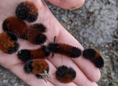
Mapping plays an important role in conservation. From assessing the value of lands for conservation to tracking the spread of an invasive species invasive species
An invasive species is any plant or animal that has spread or been introduced into a new area where they are, or could, cause harm to the environment, economy, or human, animal, or plant health. Their unwelcome presence can destroy ecosystems and cost millions of dollars.
Learn more about invasive species , maps help conservation managers make more effective decisions. Lead realty cartographer Kendra Maty has built a lot of maps throughout her career with the U.S. Fish and Wildlife Service, but the maps she helped build at Johnston Atoll National Wildlife Refuge were the beginning of the end for the invasive yellow crazy ants’ reign over the island.
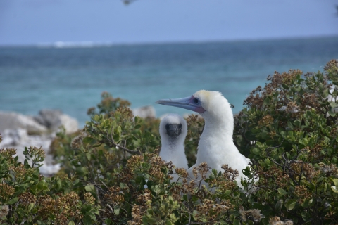
A three day boat ride southeast of Honolulu, Johnston Atoll National Wildlife Refuge, part of the Pacific Remote Islands Marine National Monument, is one of the most remote atoll formations in the world. Once a guano mine and later a military installation, the atoll is the only seabird habitat in 570,000 square miles of open ocean. Tens of thousands of seabirds are the only island residents, and they depend on the atoll as a safe place to nest and rest. Likely accidentally introduced by humans, the yellow crazy ant sprays formic acid on nesting seabirds and chicks causing injuries, deformities and infections that can lead to death. Mapping played an essential role in tracking the yellow crazy ant as it marched across the island and identifying the areas where they could be eradicated.
In addition to lending her mapping expertise, Maty collected important seabird nesting data, led several of the Crazy Ant Strike Teams (CAST), provided essential training and participated in almost every CAST deployment. Each team was different, composed of approximately 10 volunteers and Service staff. Working in a remote deployment is far different from the day-to-day in the office. Each CAST lives and works together in a remote field camp — and there’s no such thing as food delivery on the island! With no permanent infrastructure to support the field camp, the crews had to bring all the food, water, shelter, safety and scientific supplies they would need for the duration of their time on the atoll.
“Working with over 20 deployments over 10 years, it has been fun to get to know each of the new crews — their diversity, knowledge and expertise,” said Maty. “You don’t really know what it is to work in such a remote location until the boat leaves the island — and won’t return for six months!”
Over time, and lots of hard, innovative work, the teams were able to beat back the invasion. Today, the island is once again a safe haven for seabirds and the ants have officially been eradicated.
“It’s amazing to look at all the work we’ve done at Johnston Atoll — the volunteers, the refuge staff — everyone has worked so hard for over 10 years,” said Maty. “To be one of the first places to eradicate these ants in the U.S. — it makes me so proud that this island belongs to the seabirds again.”
Maps aren’t just tools for conservation managers — they can be windows into another world and a way to explore when you can’t get there yourself. Growing up, Maty would pour over maps with her grandparents whose travels inspired her to learn about all the adventurous places in the world.
“I loved maps. I would think, like, how does somebody layout and make the roads and show the mountains and towns? Living in a small town, maps opened up the world to me,” said Maty. “In college I discovered I could work with wildlife and build maps — it was the melding of two worlds!”
Maty studied marine biology, geography, and cartography at Oregon State University. She graduated with a degree in geography and cartography, quickly finding a place with the U.S. Fish and Wildlife Service.
“I started working for the agency as a volunteer, then a contractor and then was hired full time to work in the realty program as a cartographer,” said Maty. “I was really lucky to find a place. When I was in college, I didn’t realize these different possibilities. I encourage anyone interested in conservation to ask questions, volunteer, and take advantage of any opportunity — it may lead to a career.”
The National Wildlife Refuge system includes over 500 refuges across the country and protect America’s lands and waters for future generations. These public lands are acquired through purchases from landowners who want to sell their land and see it protected. Land purchases are made using funds from the Land and Water Conservation Fund and Migratory Bird Conservation Fund.
“Realty specialists and surveyors go out and we purchase lands for conservation, for protection, but also for public enjoyment and outdoor recreation,” said Maty. “As a cartographer, I actually create the data and maps to display those conservation areas. Our jobs can be a combination of conservation and public outreach because the conversations and the visuals are an important part of decision making.”
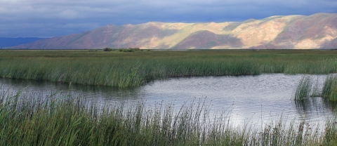
The foundation of a high quality map is good data and Maty has been a champion of ensuring high quality data collection, storage and sharing with the public. The International Snowy Plover Project is one of Maty’s past projects that combined the collection of data and the creation of maps. A threatened shorebird, plovers can be found nesting along Pacific Ocean coastlines, bays, and estuaries — even alkaline lakes. Though population and nesting information about these charismatic and cryptic bird existed along its coastal habitats, that data was missing when it came to their inland homes — the interior and Gulf Coast of the U.S. and coastal Mexico.
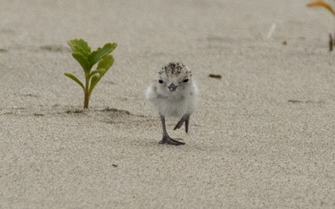
“For the International Snowy Plover project, I worked closely with colleagues and helped develop all the data collection protocol setup, mapping setup, said Maty. “I also went to the field and actually collected data (presence/absence counts) at the various interior alkaline lakes within the western states.”
The survey ultimately obtained an estimate of breeding snowy plovers at current, historic and potential breeding sites. By adding this information to the knowledge about plovers, conservation managers are able to make better decisions to support the work to remove them from the Endangered Species List.
Throughout her career, Maty has made a difference for conservation. In 2022, she was awarded the 2021 Rudolf Dieffenbach for her contributions to the realty program regionally and nationally — providing support for two regions of the Service, mentoring new colleagues, and implementing new regional and national tracking systems that resulted in more efficient and effective workload management. The award also recognized the important role she played in the eradication of yellow crazy ants from Johnston Atoll, both in the field and from the office. After 20 years working in the Service, Maty continues to ask questions and look for the opportunities to innovate and find ways to use maps to conserve more plants, more fish, more wildlife.
“Sometimes on my break I will look at the recent satellite images of Johnston Atoll,” said Maty. “Being able to see the island as it fills back up with vegetation and seabirds is rewarding.”
Maty’s love for mapping and wildlife is evident in her work ethic and stories from the field.
“I love it, these are really, really cool projects that we work on,” said Maty. “They help people connect with these places and understand the importance of conservation.”
The U.S. Fish and Wildlife Service works with others to conserve, protect and enhance fish, wildlife, plants and their habitats for the continuing benefit of the American people. For more information, visit https://www.fws.gov/about/region/pacific and connect with us on social media: Facebook, Instagram, Twitter, LinkedIn, Flickr, and YouTube.