Written By

Every culture that passes through the world leaves records of its past behind. Alaska’s many islands, while considered remote today, are filled with evidence of people living from the bounty of their homelands, dating back at least 9,000 years. World War II, fought along these islands on land, by sea, and in the air, introduced a new, toxic record to the area's history. Efforts to clean up hazardous waste from the war are still ongoing. But on one small island, cleanup also created a window into the past in a unique way.
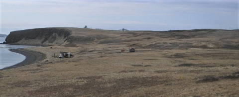
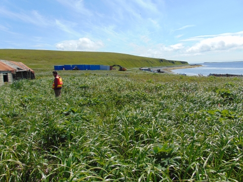
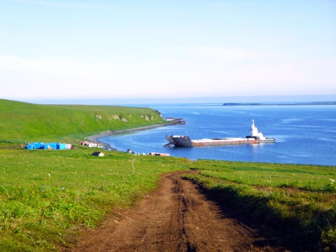
Caton Island is part of the Sanak Archipelago, 30 miles south of the Alaska Peninsula. It is a place rich in marine life, with whales, sea otters, and sea lions in the nearby waters, a wealth of clams and crabs, and nesting habitat for a variety of birds. Today, it is part of the Alaska Maritime National Wildlife Refuge.
The refuge also manages thousands of other wildlife-rich islands, including several areas which form the Aleutian Islands World War II National Monument. Refuge staff members work with partners to remediate and help heal the scars of war on refuge lands.
"It is remarkably satisfying to see these places brought back to a good condition, places for healthy wildlife and happy people,” said refuge manager Steve Delehanty.
Caton Island: wartime communications outpost in the fog
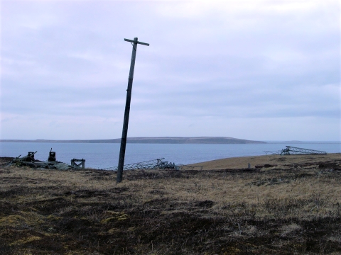
In 1942, a radio navigation range was built here by the Civil Aeronautics Authority (CAA), part of an enormous effort to make flying airplanes safer in Alaska. The Aleutian Islands became the focus of intensive effort by the U.S. Navy to dislodge Japanese invaders from the islands of Kiska and Attu and launch bombing raids into Japanese territory. The long chain of islands that divides the Pacific Ocean from the icy Bering Sea is known for its near-constant clouds and fog, making navigation particularly difficult.
Dozens of radio navigation ranges were set up to help guide planes when weather rendered them blind. Each had four radio towers that broadcast continuous Morse code signals. Navigators listened carefully to hear short dots from one tower and longer dashes from another. When the sound was one unbroken tone from the combined signals, the plane was on track. Aleutian stations also had a fifth tower to transmit voice messages and broadcast weather and route information.
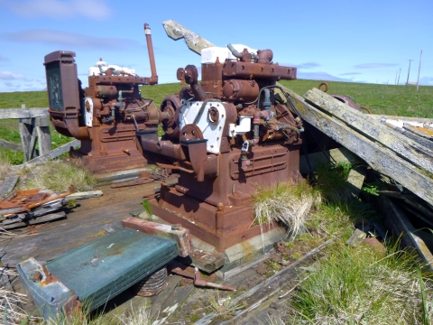
Ten enlisted men and one officer from the U.S. Navy lived full-time on Caton Island, operating the radio range, from 1943 to 1945, when the site was abandoned. Left behind were buildings with asbestos, lead paint, motor fuel, engine generators, electric poles, solvents, and a dump. Chemicals leached into the soil and into the remains of ancient homes.
In 2019, after a delay of 74 years, a crew finally removed everything left behind from the war.
Site cleanup of contaminated soil with an archaeological approach
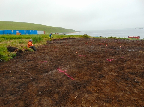
The Federal Aviation Administration (FAA) has the responsibility for cleaning up old CAA sites. They worked with the refuge, the Alaska State Historic Preservation Office, and the Pauloff Harbor Tribe to plan the historical preservation part of the cleanup on Caton Island. Because the footprint of the radio navigation range overlapped known Unangan village sites, part of the plan included archaeological monitoring. The FAA contracted a company to monitor site cleanup that included a Senior Archaeologist, Ned Gaines, who arrived on the island with the project team June 21, 2019.

Ned wasn’t there just to keep an eye on things. He also planned to try an excavation technique new to Alaska, but common in the desert Southwest, where he studied at the University of Arizona. The project’s heavy equipment operator modified a four-foot belly scraper blade and mounted it on an excavator. The operator then scraped a level few inches at a time, removing soil contaminated with diesel fuel while also allowing Ned to keep close tabs on what was being uncovered.
“We’re cleaning up the environment and simultaneously recovering irreplaceable archaeological data. It’s incredibly efficient,” Ned said. This mechanical stripping excavation method, he believes, could be very useful in Alaska, since much of the archaeology being done in the state, and in the Aleutians in particular, is associated with remediation projects like the one on Caton Island, removing contaminated soil.
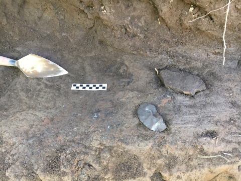
Beneath the glass, metal, and other modern debris, evidence of the past included bone and stone tools, shell middens and bones from a wide range of local foods, charcoal from hearths to use for radiocarbon dating, and house and storage pits.
The earliest date found during the project was from about 3,500 years ago. A gap in the chronology occurs after 1826 AD. This corresponds to a dark time in the history of the local people, when Russian American Company traders disrupted the lives of local people, removed them from their homes, and forced them to hunt sea otters.
Immigrants from outside Alaska, many from Scandinavia and northern Europe, arrived after the Civil War to fish for cod and salmon and farm foxes. Cattle grazing began before 1930 and continued until the last ranchers left in the 1970s. In 1982, the refuge acted to protect native plants and birds. The island is free now of non-native foxes and cattle, but their bones appeared in the layers of excavated earth.
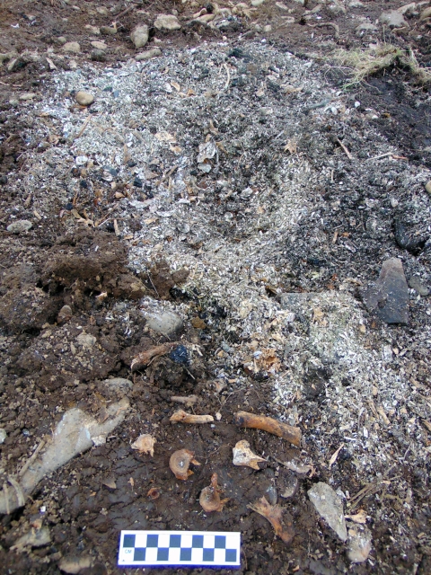
Deeper in the earth, shell middens overlaid castaway fish bones of cod and salmon. The deepest layers turned up marine mammal bones in abundance. These layers of organic trash trace cultural shifts in how the human residents made a living. Tools and the tell-tale debris of tool-making also appeared.
“We recovered stone flakes down to the size of a pinkie fingernail,” said Ned, proving that heavy machinery can be surprisingly delicate in stripping layers of soil. He noted that all the stone tools found showed re-sharpening, even the smallest useful pieces of larger broken items. This reflects how poor the local rock is for tools. Residents traded or traveled to get better material: basalt from 60 miles north on the Alaska Peninsula; slate from Kodiak over 350 miles east; obsidian from Umnak Island 250 miles west or even from Siberia.
A visit to the island today will find no trace remaining of a war. The invisible toxins are gone, hauled away at the end of the 2019 cleanup project. In the grass and the spongy mat of mosses, lichens, sedges, and flowering plants typical of tundra, still visible to a careful eye, are the outlines of centuries-old sod houses, collapsed and fading into the earth.
The descendants of the people who lived here return seasonally to collect food and other materials, still connected. The nesting birds that dive and swoop overhead, the sea lions that haul out on the beach, the berries that flourish ashore are safe now from contaminants. And a literally ground-breaking technique for effective archaeology has been tested and proven in Alaska. As Ned said, “This is a win all around.”