Land Protection Planning
The U.S. Fish and Wildlife Service is proposing to expand conservation in the Southern High Plains region including Muleshoe National Wildlife Refuge (Bailey County, Texas) by preparing a Land
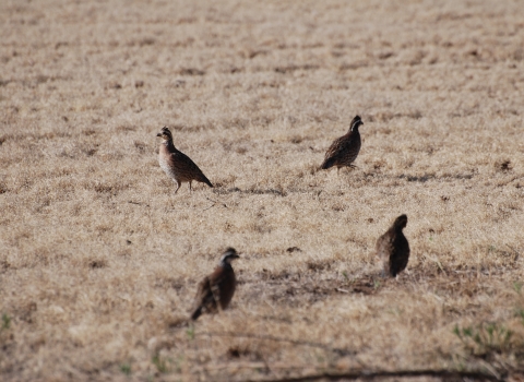
Protection Plan. The Service has worked with conservation partners to identify a conservation strategy centered on maintaining the long-term viability of the two existing refuges and the Southern High Plains region. The strategy focuses on key grassland and wetland habitat associated species including sandhill crane, lesser prairie-chicken, and pronghorn antelope.
A Land Protection Plan better positions the conservation community to address the current and future needs of wildlife and wildlife habitat in the Southern High Plains region as opportunities for future conservation arise. Draft expansion boundaries have been identified, including priority areas within. The proposed boundary encompasses the entire area under consideration for conservation partnerships. Priority areas include lands where conservation efforts will have the highest anticipated benefit to wildlife and habitat.
How Can I Participate?
The U.S. Fish and Wildlife Service is requesting comments on a draft Land Protection Plan (LPP) and Environmental Assessment (EA) for Muleshoe National Wildlife Refuge. A physical copy of the plan can be reviewed at the Refuge or FWS Regional Headquarters in Albuquerque. Please send comments or questions to r2_plancomments@fws.gov. Comments will be accepted for 30 days from January 3 to February 3, 2023.
What is the Land Protection Plan for?
The Service has prepared this draft Land Protection Plan/Environmental Assessment with the intent of establishing a limited acquisition boundary (also referred to as a Conservation Partnership Area) for Muleshoe National Wildlife Refuge. Within this proposed boundary, the Service would work only with willing sellers to expand conservation through fee title and easement acquisitions consistent with our Strategic Growth Policy.
Where Would the Plan Apply?
The LPP encompasses a portion of the Southern High Plains ecoregion in New Mexico and Texas where habitat for sandhill crane, pronghorn, and lesser prairie-chicken remains. This habitat could be readily enhanced through connectivity corridors and preservation of existing large block grasslands, playa wetlands, and saline lakes. The goal is to deliver in-perpetuity conservation of up to 700,000 acres of land, enhancing wildlife populations, preventing future listing of endangered or threatened species, and supporting the delisting of listed species.
How Was the Plan Developed?
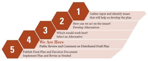
The LPP represents nearly 15 years of research, cooperation, and iterative planning by the Service conservation partners in the region. In the fall of 2021, the director of the Service approved a Land Protection Strategy, acknowledging the sound scientific basis for this LPP and the viability of the conservation partnerships refuge staff have fostered to ensure its success. The Land Protection Strategy provided the outline for the more detailed plan presented in this document.
If the proposed LPP is implemented, the Service would expand conservation for sandhill crane, pronghorn, and lesser prairie-chicken, as well as a full suite of other wildlife that relies on the same habitat types. This conservation would be durable, in-perpetuity protection of habitat from anthropogenic forces including energy development, climate change climate change
Climate change includes both global warming driven by human-induced emissions of greenhouse gases and the resulting large-scale shifts in weather patterns. Though there have been previous periods of climatic change, since the mid-20th century humans have had an unprecedented impact on Earth's climate system and caused change on a global scale.
Learn more about climate change , habitat fragmentation, and aquifer decline.
This proposed plan includes 5 Focal Areas where conservation would have the highest benefit to sandhill crane, pronghorn, and lesser prairie-chicken. The boundaries of focal areas have been selected to encompass different types of habitat, such as shortgrass prairie, playa wetlands, saline lakes, and connective corridors.
The preparation of this plan was possible with the support of numerous conservation partners and landowners across the Southern High Plains ecoregion in New Mexico and Texas. The Service is grateful for everyone whose scientific contributions, planning support, and methodical input is reflected in this draft.

Frequently Asked Questions
If I own land in the expansion boundary or priority area, would I ever be forced to sell?
No. The expansion boundary and priority boundaries are not refuge boundaries. All property acquisition by the Service would be on a voluntary basis (willing buyer/willing seller only) and only lands in which the Service acquires a fee/title realty interest would become part of a refuge. Lands identified in the expansion boundary and priority area are in private and public ownership. It is not the intent of the Service to acquire lands already in public ownership. Only in the presence of willing sellers and only after detailed planning could lands be acquired for the refuge.
If I own land in an area that the Service says has high natural resource values, will my property ever be condemned?
The Service will not use eminent domain or condemnation to acquire lands. As the opportunity arises, the Service will acquire land from interested landowners within the planning areas who wish to sell or place easements on their land for the conservation of wildlife.
Will my rights as a property owner be infringed as a result of the refuge expanding its boundaries?
No. If lands are developed into a National Wildlife Refuge, the Service will have no more authority over private land within or adjacent to the boundaries of the refuge than any other landowner. Landowners retain all the rights, privileges, and responsibilities of private land ownership.
Is this the recovery plan for lesser prairie-chicken?
No. This is not a recovery plan or strategy for the lesser prairie-chicken as recovery planning is its own process. Conservation of the lesser prairie-chicken is reliant upon efforts well beyond this Land Protection Plan. Since the lesser prairie chicken population in the plan area is listed as endangered under the Endangered Species Act (ESA) the Service will begin to outline steps that would need to occur for recovering the species. The recovery plan will identify recovery criteria for review of when a species may be ready for downlisting or delisting, and methods for monitoring recovery progress.
If a Land Protection Plan for expanding Muleshoe National Wildlife Refuge is finalized, any resulting conservation benefits for the lesser prairie-chicken realized from this effort may contribute towards meeting any potential recovery goals established through a recovery planning process.
Will this effort effect the listing determination for the lesser prairie-chicken?
No. This is a planning effort that may result in conservation benefits to the lesser prairie-chicken in the future if finalized. The scope of any potential benefits to the lesser prairie-chicken are unknown at this time and will depend upon the amount and location of any potential future conservation that may arise from this planning process.
I am a landowner; how will a conservation easement conservation easement
A conservation easement is a voluntary legal agreement between a landowner and a government agency or qualified conservation organization that restricts the type and amount of development that may take place on a property in the future. Conservation easements aim to protect habitat for birds, fish and other wildlife by limiting residential, industrial or commercial development. Contracts may prohibit alteration of the natural topography, conversion of native grassland to cropland, drainage of wetland and establishment of game farms. Easement land remains in private ownership.
Learn more about conservation easement or fee-title sale benefit me?
Conservation easements provide permanent protection to natural resources while retaining private landownership. The landowner retains ownership of the land but sells certain rights identified and agreed upon by both parties. The value a landowner may expect to receive for an easement is dependent on the number of rights the landowner chooses to sell. Because ownership of the land remains with the individual, the property remains on the state and local tax rolls. The Service pays fair market value for property and any rights purchased.
Fee-Title Acquisition involves an interested landowner requesting the U.S. Fish and Wildlife Service acquire most or all the rights to their property. There is a total transfer of property with the formal conveyance of a title to the federal government. In some instances, certain rights such as water rights, mineral rights or use reservations, such as grazing, can be negotiated at the time the property is transferred in ownership. The Service pays fair market value for property and any rights purchased.