


Visit Us
National wildlife refuges offer us all a chance to unplug from the stresses of daily life and reconnect with our natural surroundings. Located right along the Missouri River, Boyer Chute National Wildlife Refuge provides a number of great opportunities to explore, discover and learn about the plants, wildlife and habitat of the Missouri River floodplain. The auto tour route and extensive trail network are open year-round and visitors can enjoy activities such as hiking, bird watching, and nature photography. The namesake chute runs alongside the auto tour and multiple parking lots provides access for visitors to observe this Missouri River side channel or to try their luck fishing for common river fish species such as catfish and sauger.
In the spring time, look for morel mushrooms in the open areas of the refuge. These prized edibles can flourish in the Missouri River bottomland habitat. The refuge also offers hunting opportunities for turkey, white-tailed deer and waterfowl. To learn more about these opportunities or other activities on the refuge contact refuge staff at 712-388-4800.
Driving Directions
Boyer Chute National Wildlife Refuge is located on the west side of the Missouri River, 3 miles east of the town of Fort Calhoun, Nebraska. Being eight miles north of Omaha, the refuge attracts day-use visitors from throughout the Omaha/Council Bluffs metropolitan area.
From Omaha or Blair, take Highway 75 to the southernmost street (Madison Street) within Fort Calhoun city limits. Note sign for Boyer Chute National Wildlife Refuge. Turn east on Madison Street and proceed to stop sign at "T" intersection. Turn right onto County Road 34 and proceed approximately 3 miles to refuge main gate.
Fees
There is no charge to visit Boyer Chute National Wildlife Refuge.
Restrooms
Restrooms are available at the Main Parking Lot and the North Chute Parking Lot. These are accessible during open hours of the refuge.
Points of Interest
Start your visit at Boyer Chute National Wildlife Refuge with a drive on the auto tour route. This short drive takes you along the edge of the restored chute. Along the route are a number of parking lots providing access points to stop and bank fish along the Missouri River side channel or just to explore. At Sauger Parking Lot is an observation platform that extends out over the chute and provides for a good scenic view of this restored waterway. From the Main Parking Lot originates most of the trail system. A bridge from the Main Parking Lot will take visitors over the chute and onto Boyer Island. The island has an extensive network of trails along with a picnic shelter for visitors to enjoy. Boyer Chute does not have an office of visitor contact station. If you have questions regarding your visit, please contact the staff by calling the main number for DeSoto National Wildlife Refuge at 712-388-4800.
What to Do
If you have 15-minutes.
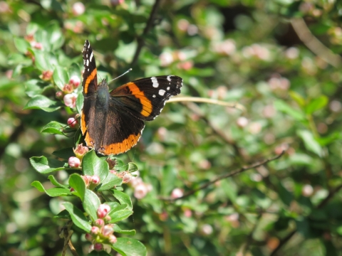
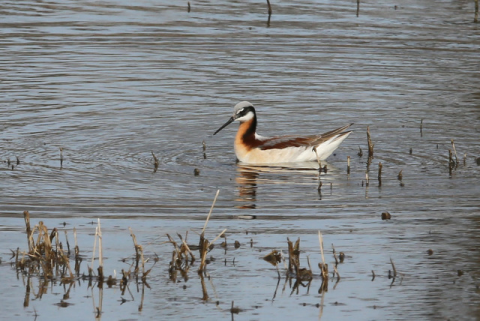
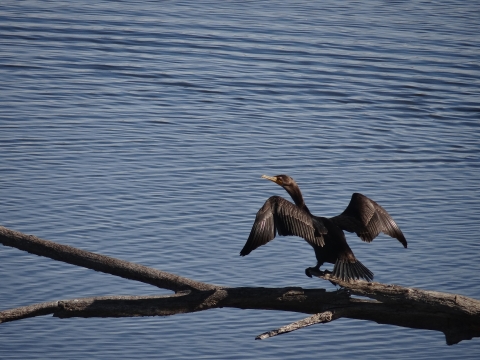
- Take a drive on the Auto Tour Route and stop at the Sauger Parking Lot. A short paved trail will take you to an observation platform that provides a scenic vista of the restored chute. Look for herons, belted kingfishers, turtles and other wildlife along the waterway.
If you have one hour.
- Enjoy the Auto Tour Route and stop at the various access points to observe the habitat along Boyer Chute. From the main parking lot, take a hike on the Oriole Trail Loop. This trail, located on Boyer Island just across the bridge from the main parking lot, takes visitors through a diversity of Missouri River floodplain habitats. It starts off along the edge of a mature bottomland forest before winding along the chute and then looping back through young cottonwood forests and grassland habitats. Along the trail, look for deer, turkey, and a variety of forest edge and grassland birds.
If you have half a day or more.
- Enjoy the full length of the auto tour route and stop off at the North Chute Parking Lot. A short walk from the parking lot takes visitors to the start of the chute where the Missouri River feeds into Boyer Chute. Fishing is popular at the north chute area as the churning waters can provide a good place to catch catfish and other river fish species. After exploring the chute, enjoy a hike on one of the longer trails on the refuge. The North Island Trail and South Island Trail are both 3.5 miles long and take visitors through the diverse Missouri River flood plain habitats. Each trail cuts across Boyer Island to the edge of the Missouri River and the Boyer Bend Backwaters. Look for eagles and waterfowl along this stretch. After a long hike, take a break and enjoy a picnic at the picnic shelter or along the banks of the chute.
Know Before You Go
When planning a trip to the refuge please be aware that there is no refuge office or visitor contact station on the refuge. Boyer Chute is managed by nearby DeSoto National Wildlife Refuge and any questions regarding your visit to Boyer Chute can be answered by calling the DeSoto Visitor Center at 712-388-4800.
When visiting the refuge remember to wear appropriate footwear and dress for the weather. Bring water, food, binoculars, field guides, a hat, sunscreen, insect repellent and anything else that might make the outdoor experience more enjoyable.
Visitor Tips
When planning your visit to Boyer Chute National Wildlife Refuge be aware that the refuge is self-guided and does not have a refuge office or visitor contact station onsite. Refuge kiosks and brochures can be found at the main entrance and parking lot and are a good place to stop to get orientated to the refuge and to pick up a brochure for your visit. When visiting for wildlife viewing or photography, it is best in the morning and evening times, especially during the hot summer months. The time of year will also play a role in the wildlife that you may see on the refuge. During the spring and summer months look for a variety of warblers, sparrows, woodpeckers and other songbirds in the grassland and bottomland forest habitat. The winter time is best for viewing eagles, especially along the river and mouth of the chute.

If looking to enjoy other recreational activities on the refuge, remember that some may be seasonal in nature or have special restrictions. Limited hunting opportunities are allowed on the refuge and interested hunters should contact the refuge prior to their visit. The chute is open year-round for fishing when conditions allow. However, typically during the winter months the water level drops significantly and it becomes too shallow for fishing. Bait and fishing poles are not available onsite so visitors should come prepared with their supplies. Limited bait supply can be found in Fort Calhoun or Blair, Nebraska.
Finally, visitors are encouraged to check status of the refuge prior to visit. Its location along the Missouri River means flooding is a frequent issue and can impact visitor access. If you have any questions regarding your visit please call us at 712-388-4800 and the staff and volunteers will be happy to provide information about your visit and any regulations regarding refuge activities.
Activities
Welcome to your national wildlife refuge national wildlife refuge
A national wildlife refuge is typically a contiguous area of land and water managed by the U.S. Fish and Wildlife Service for the conservation and, where appropriate, restoration of fish, wildlife and plant resources and their habitats for the benefit of present and future generations of Americans.
Learn more about national wildlife refuge . Boyer Chute National Wildlife Refuge provides a number of activities to enjoy nature throughout the year including hunting, fishing, hiking, wildlife viewing and photography. Some of these activities are offered seasonally and have special regulations. To learn more about permitted activities, pick up a refuge brochure when visiting or call us at 712-388-4800 with any questions.
Trails
North Island Trail
Open Season: Year-round
Length: 3.6 miles
Location of trail: Originates just east of bridge from main parking lot and heads north from the trail head junction.
Surface: Mowed grass
Difficulty: Moderate with little elevation change.
Information: This North Island Trail provides visitors views of the Missouri River and the restored backwaters area. During the migration, look for waterfowl and eagles along the river’s edge.
South Island Trail
Open Season: Year-round
Length: 3.5 miles
Location of trail: Originates just east of bridge from main parking lot and heads south from the trail head junctions.
Surface: Mowed grass
Difficulty: Moderate with little elevation change
Information: This long loop trail winds through grassland and early successional bottomland forest before coming along the edge of the Missouri River backwaters area. Look for deer, turkey, and a variety of songbirds along this trail.
South Chute Confluence Trail
Open Season: Year-round
Length: 0.65 miles
Location of trail: Originates from the South Chute Parking Lot..
Surface: Mowed grass with wood bridge section
Difficulty: Easy with little elevation change
Information: The South Confluence Trail follows the edge of the chute to where it meets with the Missouri River. Bank fishing opportunities can be found along the stretch of the trail.
Other Facilities in the Complex
Boyer Chute National Wildlife Refuge is managed together with DeSoto National Wildlife Refuge, which is located just upriver. DeSoto National Wildlife Refuge contains similar Missouri River floodplain habitat to Boyer Chute and is best known for the incredible number of migratory waterfowl that utilize the refuge as a sanctuary and resting place. Within its 8,365 acres lies DeSoto Lake, which is an oxbow lake that used to be a bend in the Missouri River. DeSoto National Wildlife Refuge also contains a piece of history within its borders, the Bertrand Steamboat. The Bertrand sunk on the bend of river that is now DeSoto Lake leaving behind the cargo and historic time pieces, amounting to almost 250,000 different artifacts housed within the walls of the DeSoto Visitor Center. For questions regarding DeSoto or Boyer Chute National Wildlife Refuge, contact the staff of DeSoto at 712-388-4800.

Rules and Policies

Welcome to your national wildlife refuge national wildlife refuge
A national wildlife refuge is typically a contiguous area of land and water managed by the U.S. Fish and Wildlife Service for the conservation and, where appropriate, restoration of fish, wildlife and plant resources and their habitats for the benefit of present and future generations of Americans.
Learn more about national wildlife refuge . Boyer Chute National Wildlife Refuge provides a number of activities to enjoy nature throughout the year including hunting, fishing, hiking, wildlife viewing and photography. The refuge does have areas that are closed year-round or seasonally to the public to provide important sanctuary areas for wildlife. To help protect and minimize disturbance to wildlife and its habitat, the refuge has other rules and regulations regarding activities on the refuge. To learn more about permitted activities, pick up a refuge brochure when visiting or call us at 712-388-4800 with any questions.
Locations
Boyer Chute National Wildlife Refuge is located on the west side of the Missouri River, 3 miles east of the town of Fort Calhoun, Nebraska. Being eight miles north of Omaha, the refuge attracts day-use visitors from throughout the Omaha/Council Bluffs metropolitan area.
From Omaha or Blair, take Highway 75 to the southernmost street (Madison Street) within Fort Calhoun city limits. Note sign for Boyer Chute National Wildlife Refuge. Turn east on Madison Street and proceed to stop sign at "T" intersection. Turn right onto County Road 34 and proceed approximately 3 miles to refuge main gate.