

Photo By/Credit
Jones-Farrand, Todd
Media Usage Rights/License
Public Domain
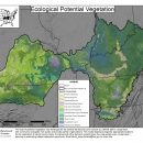
Image
Map showing where to restore natural communities developed to support avian conservation by the CHJV. When combined with other CHJV decision support tools, this map can estimate extent of habitat restoration opportunity. This map of potential vegetation was developed for the Central Hardwoods Joint Venture by USFWS staff in cooperation with community ecologists from public and private partner organizations. This model was developed by assigning natural communities to appropriate landform positions (e.g. ridge tops) within Land Type Associations. Thus, the model depicts ecologically appropriate locations for the restoration of natural communities. When combined with other decision support tools developed by the CHJV staff &/or partners, this map can guide conservation planning by estimating habitat restoration opportunity.