


Beginning July 6, 2026, the auto-tour route will be closed to all motor vehicles. Pedestrians and bicyclists can still access the auto-tour route but the exit at Deep Creek will be closed, thus access is only available by Refuge headquarters. Visitors do need to be aware that heavy equipment and trucks will also be traveling on the auto-tour route during this time.

Road improvements will close Riverside Road between the Deep Creek Bridge and Lion’s Den Road until the fall. There may be other closures and associated delays when visiting the refuge.
Visit Us

Kootenai National Wildlife Refuge currently offers all of the Big Six wildlife-dependent public uses which include hunting, fishing, wildlife observation, photography, environmental education and interpretation. The 2,774 acre Refuge offers waterfowl, big game and upland bird hunting; fishing; four walking/hiking trails; an Auto Tour Route; and an Environmental Education Center. Public restrooms and a picnic area are provided to the public that are located near headquarters. No Fees are charged to the public.
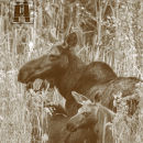
Bring your binoculars and camera to view the many migratory birds and other wildlife on the refuge. Plan ahead with plenty of drinking water, snacks, insect repellant, sunscreen and other necessitates on hand. This is black bear and grizzly bear country--carrying bear spray while hiking is a good idea. Dress appropriately for the seasons and wear comfortable walking shoes.
The Auto Tour Route may be closed in winter months or when conditions warrant. Please call ahead to check the status: 208-267-3888.

Trails
Kootenai NWR is an excellent place to visit for those looking to take a leisurely walk, engage in some birding, and bike or drive the scenic auto tour route.
Restroom facilities can be found at refuge headquarters.
Respect wildlife and their habitats by observing and obeying all refuge rules and policies. Do not feed or harass wildlife. If an animal changes its behavior, you’re too close and need to back away.
For a full list of trails, please stop by refuge headquarters or explore the interactive map.
Related Documents
The primary entrance to the Refuge can be accessed by Hwy 95 in Bonners Ferry, Idaho. From Hwy 95, head west on Riverside Rd. for about 6 miles, following alongside the Kootenai River to the refuge entrance sign. Access Refuge Headquarters and the Auto Tour Route by following Riverside Rd. another 2 miles, turn slightly right onto Westside Road, and headquarters is 0.25 miles on the right.

Other Facilities in the Complex
The Inland Northwest National Wildlife Refuge Complex includes three National Wildlife Refuges, several subunits, and conservation easements in northeastern Washington and northern Idaho. The refuges, Turnbull, Little Pend Oreille and Kootenai, are managed as a complex, sharing common work priorities, budgets, and some staff. Turnbull National Wildlife Refuge serves as the complex headquarters. Turnbull, located just outside Cheney, Washington, is a 2-3 hour drive from Little Pend Oreille and Kootenai Refuges, respectively.
Despite common management oversight, each of the three complex refuges is unique.


Rules and Policies
For the protection of wildlife and visitor safety, rules and regulations apply throughout the refuge. Please abide by posted signs and contact the refuge before participation in an activity that could harm the environment or yourself.
Prohibited Activities
Camping, horseback riding, fires, firewood gathering, flying of drones/unmanned aircraft, overnight parking, swimming, and on-ice activities are prohibited on the refuge. Snowmobiles and unlicensed ATV’s are not allowed on Refuge lands or roads. The collection of any plant or animal or parts thereof is prohibited except licensed hunting in accordance with state and federal law or under Special Use Permit.
Access to all closed areas of the refuge is prohibited.
Locations
The primary entrance to the Refuge can be accessed by Hwy 95 in Bonners Ferry, Idaho. From Hwy 95, head west on Riverside Rd. for about 6 miles, following the dike along the Kootenai River. After crossing over Deep Creek, you will see a welcome sign as you enter the Refuge property. You may continue on to headquarters by following Riverside Rd. another 2 miles, turn slightly right onto Westside Rd. and headquarters is 1/4 mile on the right.