


What We Do
Wildlife conservation is at the heart of the National Wildlife Refuge System. It drives everything on U.S. Fish and Wildlife Service lands and waters managed within the Refuge System, from the purposes for which a national wildlife refuge national wildlife refuge
A national wildlife refuge is typically a contiguous area of land and water managed by the U.S. Fish and Wildlife Service for the conservation and, where appropriate, restoration of fish, wildlife and plant resources and their habitats for the benefit of present and future generations of Americans.
Learn more about national wildlife refuge is established to the recreational activities offered to the resource management tools used. Using conservation best practices, the Refuge System manages Service lands and waters to help ensure the survival of native wildlife species.
Conservation management on the refuge includes nest protection for the threatened Loggerhead sea turtle, bird surveys and protection of nesting areas for migratory seabird and shorebirds, husbandry for the endangered Red wolf, and measures to eradicate invasive plant species. Water control structures at impoundments are managed to maximize food supplies for waterfowl, wading birds and shorebirds. Habitat enhancement and restoration practices are undertaken to protect the maritime forest and provide quality spaces for wildlife.
Compatible wildlife recreation managment includes hunting and fishing. The refuge offers annual white-tailed deer archery hunts that support a healthy deer population and provide a traditional and popular recreation activity. Visitors surf fish off the beaches, fish in the estuaries and cast off the refuge pier for a variety of finfish species. Shellfish and crustaceans that include oysters, clams, crabs and shrimp, are harvested commericially and for recreation. All salt water fishing in refuge waters is managed by the state.
Management and Conservation
Refuges deploy a host of scientifically sound management tools to address biological challenges. These tools span active water management to wilderness character monitoring, all aimed at ensuring a balanced conservation approach to benefit both wildlife and people. At this field station our conservation tool box includes:
Planning: The Cape Romain NWR Comprehensive Conservation Plan (CCP) describes how the refuge will contribute to the mission of the Refuge System. Direction and implementation includes managing habitat and wildlife populations, controlling invasive species invasive species
An invasive species is any plant or animal that has spread or been introduced into a new area where they are, or could, cause harm to the environment, economy, or human, animal, or plant health. Their unwelcome presence can destroy ecosystems and cost millions of dollars.
Learn more about invasive species , hunting, fishing and other public recreation use.
Air Quality Protection: The refuge is a part of the Interagency Monitoring of Protected Visual Environments (IMPROVE) program that includes the Air Quality Research Center (AQRC) of UC Davis, and other federal agencies. The IMPROVE program measures and documents air pollution and tracks visibility, collecting and analyzing sulfate, nitrate, organic matter, soot, soil dust and salt. The refuge participates in the National Atmospheric Deposition Program (NADP) to monitor precipitation chemistry, studying acids and nutrients to improve our understanding of acidic precipitation and its environmental effects. In 2020, the refuge installed a solar powered system to further support monitoring equipment.
Climate Resilience: Rising sea levels and accelerated erosion of beach and marsh habitats are challenges posed by climate for this coastal refuge. Climate mitigation efforts include maintaining roads, dikes and impoundments on Bulls Island, conducting wildlife and vegetation surveys, and evaluating potential future land acquisition areas.
Cultural Resources: On Bulls Island, cultural history is evidenced by ancient shell mounds deposited by Native Americans, the foundation remains of a 1700’s fort, and a large vacation home built in 1925 by the last private owner of the island. Two 1800’s lighthouses and other archeological remains are found on Lighthouse Island. These sites are maintained for their historical values to the American people. Four guided tours to Lighthouse Island to view the historic lighthouses are offered annually through the refuge concession.
Education and Outreach: Environmental education, interpretive programs and outreach events are regularly scheduled at the Sewee Visitor and Environmental Education Center, offered in partnership with Francis Marion National Forest and the Friends of Coastal South Carolina. Our Friends works with refuge staff and volunteers to manage and deliver the education programming for the refuge. Coastal Expeditions, the contracted concession, conducts guided interpretive tours and environmental education programs on Bulls Island and other areas on the refuge.
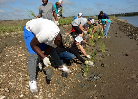
Habitat Restoration: The uplands on Bulls Island are managed to promote the growth of the maritime forest and control exotic plants like Chinese tallow. Mechanical and application methods are used to control this plant and other invasive species such as phragmities and bamboo in the water impoundments on Bulls Island.
Law Enforcement: Law enforcement officials work closely with local, state, and federal agencies to protect wildlife and habitat and to ensure public safety on the refuge. Officials enforce hunting, fishing, boating and safety regulations and enforce the migratory bird treaty act.
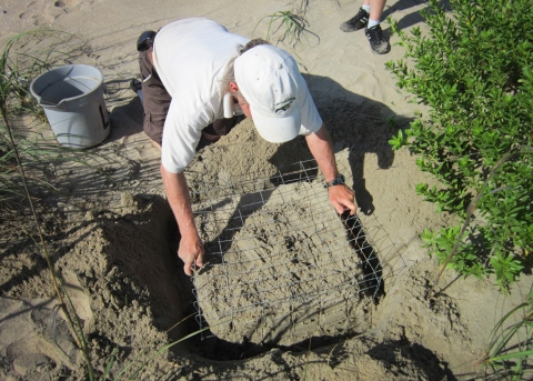
Loggerhead Sea Turtle Nest Protection: Nests on island beaches are located daily during the nesting season. If necessary, nests are relocated to safer areas to protect from water intrusion and erosion. Activities include nest marking, caging, monitoring, predator control, and genetic sampling.
Management of Water Impoundments: Impoundments on Bulls Island are managed to maximize food production for wintering waterfowl and shorebirds and to maintain habitat for resident bird species. Water control structures operate with the tides and, water levels in impoundments are manipulated to make food available during fall and winter months and to allow for new plant germination during early spring. Salt water may be added during summer months to control undesirable plant growth or to allow the influx of larval marine organisms and fish. Water quality is monitored for salinity levels and contaminants.
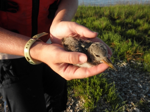
Protection of Nesting Seabirds and Shorebirds: During the spring and summer months, important bird areas for nesting and fledging are temporarily closed to the public. This includes island areas on an annual basis and a system of mobile closures used for species that do not always nest in the same areas year after year. “Area closed” signs are placed around nesting perimeters and include a large buffer zone. Once chicks have fledged, the signs are removed.
Trapping: Predator trapping is utilized on the refuge as a management tool for the conservation and protection of threatened species populations and is prohibited by the public. Trapping is used to control excessive depredation by mink, raccoon and coyote of threatened sea turtles and nesting seabirds and shorebird colonies. All trapping activity adheres to the state depredation permit issued to the refuge.
Recreation Management: Fishing
Salt water fishing for seatrout, flounder, red drum, sheepshead and other species accounts for over half of the recreational activity in the refuge, occurring throughout the estuary waters, off the beaches and on the 1,100- foot pier at Garris Landing. Shellfish and crustaceans including oysters, clams, crabs and shrimp are harvested commercially and for recreation. All fishing is managed by the state and is in accordance with applicable state regulations and licenses.
Recreation Management: Hunting
The refuge offers archery hunts for white-tailed deer on Bulls Island to maintain the deer population at a level compatible with the habitat, provide wholesome recreation opportunities and permit the use of a valuable renewable resource. Federal and state hunt regulations apply and all appropriate state licenses are required for refuge hunts. Please see the refuge hunt permit for details.
Our Services
With its diverse habitats and a myriad of wildlife and fish species these areas sustain, Cape Romain NWR has a number of services available that support opportunities for grants, education, and research.
Our Projects and Research
Since its establishment, the refuge has been a living laboratory of wildlife and habitat research and initiatives for state and federal agencies, universities and conservation organizations. Vegetation studies of maritime forest, recovery initiatives for the red wolf, climate and sea level rise projects in the marsh estuary, and seabird, shorebird and waterfowl surveys have been implemented on the refuge.
Ongoing projects include:
1. North American Bat Acoustic Bat Survey
2. Northern Recovery Unit Loggerhead DNA Project
3. Interagency Monitoring of Protected Visual Environments (IMPROVE) Program and National Atmospheric Deposition Program (NADP)
The North American Bat Monitoring Program is a nationally coordinated, long-term program. This Acoustic Bat monitoring project is part of the national effort and was initially implemented on Cape Island in 2016. Stationary acoustic equipment is used to monitor bat numbers and activity and surveys occur annually for a specified period of time. Collaborative partners include the SC Department of Natural Resources, USDA Forest Service and Clemson University. Information obtained on bat population and activity trends is being used to support management actions needed to effectively conserve bat populations.
The refuge participates in the tri-state Northern Recovery Unit Loggerhead DNA Project that includes the SC Department of Natural Resources, Georgia Department of Natural Resources and the North Carolina Wildlife Resources Commission. Answers gleaned from several basic questions on loggerhead sea turtle nesting will help biologists better understand how the loggerhead population is doing. By collecting an egg from every nest, DNA genetic fingerprinting is used to identify individual loggerhead nesting females. This information will provide a census of the actual nesting population and can answer other questions as well.
The refuge is a part of the Interagency Monitoring of Protected Visual Environments (IMPROVE) program that includes the Air Quality Research Center (AQRC) of UC Davis, and other federal agencies. The IMPROVE program measures and documents air pollution and tracks visibility. A long-term program on the refuge, particle composition collected and analyzed includes sulfate, nitrate, organic matter, soot, soil dust and salt. The refuge also participates in the National Atmospheric Deposition Program (NADP) to monitor precipitation chemistry. Acids and nutrients are studied to improve our understanding of acidic precipitation and its effects on the environment. In 2020, the refuge installed a solar powered system to further support monitoring equipment.
Law Enforcement
The mission of our National Wildlife Refuges is to protect and manage habitat and species and other natural and cultural resources. Refuge Law Enforcement plays a vital role in fulfilling this purpose as well as providing visitor protection. Law enforcement officials work closely with local, state, and federal agencies to protect wildlife and habitat and to ensure public safety on the refuge. Officials enforce hunting, fishing, boating and safety regulations, and enforce the Migratory Bird Treaty Act and other wildlife laws.
Laws and Regulations
At Cape Romain NWR, we strive to protect our natural and cultural resources and work to ensure that visitors have a safe and enjoyable visit. Please follow all rules and regulations outlined in the refuge brochure when visiting Cape Romain NWR. You can pick up the refuge brochure at our Headquarters, Sewee Visitor and Environmental Education Center, and at the kiosks at Garris Landing and Bulls Island. Signage displaying permitted and prohibited activities are found at Garris Landing and on refuge islands. Become familiar with and follow all applicable state fishing regulations while fishing in refuge waters and, follow all federal and state laws and applications when hunting on the refuge.