


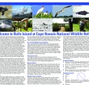
Visit Us
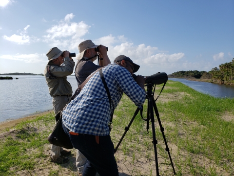
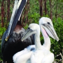
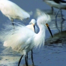
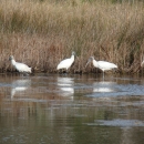
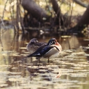
Cape Romain National Wildlife Refuge is yours to experience and explore. For many of us, being out on the refuge is a perfect "getaway" from the bustle of everyday living. Surrounded by water and marsh flats, the estuary seems endless. In the quietness, you may get lucky and hear the calls of marsh wrens or the clacking sounds of rails. You can lose track of time walking the long stretches of undeveloped and pristine beaches, picking up shell treasures as you go. If you venture into the maritime forest on Bulls Island, you get the sense that you are walking through a sub-tropical forest of sorts, with the palmettos, magnolias and bay you pass along the trail. Always be on the lookout for wildlife on the refuge, whether in the estuary or on the islands. It is not uncommon to sight Atlantic bottlenose dolphin and, in the late spring and summer months, the Loggerhead sea turtle may be sighted in the estuary. Are you a birdwatcher? If so, you have come to the right place. The refuge is known as a birder's "hotspot" and rightfully so. With over 293 recorded species, birdwatching is excellent throughout the year. And, Bulls Island is the place to see American alligators, white-tailed deer, black fox squirrels and even the elusive bobcat. Witness wildlife and breathtaking vistas, all of which can be captured with the naked eye or, with an artist's eye and a camera lens.
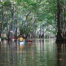
Whether a guided kayak or ferry excursion across the wilderness estuary, beach walk or trail hike, interpretive tour or education outdoor classroom, you can explore and experience the refuge. Coastal Expeditions, the refuge concession, regularly schedules outdoor adventures with professional naturalists to Bulls Island, and offers tours to other areas on the refuge as well. Environmental education programs that focus on barrier island ecology are offered to elementary schools as well as to higher institutions of learning. During the fall,winter and spring months, special overnight weekend ecology trips are extremely popular, with lodging at the island's Dominick House.
If you have a penchant for historic sites and like to learn more about our coastal history, Cape Romain has several sites that connect us with those that came before us. On Bulls Island, shell fragments from the bounty of oysters and clams that the Sewee Native American tribe gathered from the marsh estuary hundreds of years ago can be seen along the Middens and bay side of the Turkey Walk Trail. The tabby foundation remains of the Old Fort is found along Old Fort road. The fort first housed cannon to warn mainland settlers of maurading pirates and, many years later, Confederate soldiers used the structure structure
Something temporarily or permanently constructed, built, or placed; and constructed of natural or manufactured parts including, but not limited to, a building, shed, cabin, porch, bridge, walkway, stair steps, sign, landing, platform, dock, rack, fence, telecommunication device, antennae, fish cleaning table, satellite dish/mount, or well head.
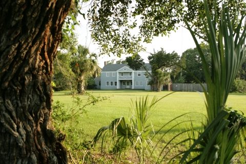
Learn more about structure for a powder magazine before being destoyed by the Union Navy. The island had 36 private owners from 1696 - 1936. Gayer Dominick, final owner, conveyed the island and his family vacation home and hunt lodge to the Service in 1936. The Dominick House, built in 1927, also provides lodging for refuge staff and volunteers when working on the island.
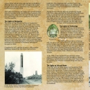
Plan ahead for a guided tour to Lighthouse Island. In 1823, the Lighthouse Board of the Treasury Department took issue with the treacherous shoals off of Cape Romain and the first lighthouse was built on Lighthouse Island in 1827. It was ineffective and shipwrecks continued to occur. The second lighthouse was built in 1857 and, with a revolving light that could be seen 19 miles out, wrecks dramatically declined. Except for two periods in our history, the 1857 light served mariners until it was decommissioned in 1947. The lighthouses and archeological remains of the lightkeeper's homes, water cisterns and wooden fencing around the compound remain. Offered only four times annually, the refuge works with the concession to provide these historic public tours to Lighthouse Island.
Sewee Visitor and Environmental Education Center
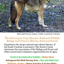
The Sewee Visitor and Environmental Education Center is your gateway to the Cape Romain NF and Francis Marion National Forest, showcasing the valuable ecosystems of the forest and refuge. Importantly, here you can observe and learn about the critically endangered Red wolf. The Center, one of over 40 captive breeding facilities, currently houses one female wolf at the enclosure. A four year old male will arrive in late summer as a companion to the female.

Activities are offered each month for families, individuals and children and you can enjoy interpretive and environmental education programs that highlight native habitats, wildlife and plants as well as participate in hands-on environmental stewardship programs. Be sure to meet our in-house resident reptiles, our native turtles, snakes and young alligator that live in the lab. View the Refuge and Forest film in the auditorium and take a walk through the "forest to sea" exhibit hall with interactive exhibits and short videos of threatened and endangered wildlife of the refuge and forest. You can find nature guides and games, T-shirts and other items for adults and children, and bottled water in the Nature Store.
Outside the Center, take the kids to the Animal Olympics course where they can have fun imitating animal behaviors while honing their physical skills. Walk the one-mile Nebo trail that takes you past the Sewee Pond, picnic pavilion and Red wolf enclosure, traversing through the oak-tupelo bottomland and upland pine forest in the Francis Marion NF. From the Nebo Trail, you can reach the Nebo ponds, three small ponds popular for catching catfish and bass. The Nebo Ponds are open for fishing during daylight hours. The Sewee Pond, adjacent to the Center is open for fishing only during special events such as the Youth Fishing Rodeo in June and the Bulls Bay Nature Festival in May.
When making preparations to visit the refuge or the Sewee Center, be sure to pack rain gear, a water bottle and insect repellent for your outdoor excursions. Check the local weather forecast and plan accordingly. Don't forget the sunscreen, especially during the summer months. Contact the Center at (843) 928-3368 or the refuge Headquarters at (843) 928-3264 for additional information.
Activities
There are wholesome recreation activites for all ages at Cape Romain NWR. Discover new outdoor interests and increase your knowledge and skills for those activities that you enjoy. Field guides are wonderful to have while visiting the refuge. You can use guides to identify some of the many birds, plants and beach shells you will see. "A picture is worth a thousand words" rings true at Cape Romain. Photo opportunities are to be found wherever you are on the refuge. Capture amazing photographs of nature, whether it be wildlife, plants, or beautiful vistas.
Fish the estuary bays and creeks and, surf-fish off the beaches for spottail bass, sea trout, flounder and other salt-water fishes. If you aren't going out into the estuary, you can fish and crab off of Garris Landing pier. Clamming, oystering, crabbing and shrimping are popular in the estuaries. For recreational finfishing and shellfishing, be familiar with state regulations and have all state licenses required.
If you enjoy the challenge of a bow, the refuge offers two annual 6-day archery hunts for deer on Bulls Island. A long-held tradition since 1955, hunters have the more primitive challenge of the recurve and compound bow on the barrier island. Due to safety and travel logistics from the mainland, hunters are allowed to camp on the island while hunting. Be familiar with all federal and state regulations and refuge policies that govern the hunt. The hunt brochure is available at the Headquarters or Sewee Center or, print the brochure from our website. The 2023 archery hunts will be held November 6th - 11th and December 4th - 9th. The camp area will remain open from 9:00 am on the Sunday preceding each hunt until noon on the Sunday following the hunt.
Trails
Cape Romain's Bulls Island has two designated hiking trails, 16 miles of unpaved service roads, two observation platforms, and a long sandy beach where visitors can experience the sights and sounds of nature. Several benches are located along the trails and roads that traverse salt marsh salt marsh
Salt marshes are found in tidal areas near the coast, where freshwater mixes with saltwater.
Learn more about salt marsh , forest, and water impoundments.
At the Sewee Visitor and Environmental Education Center, an easy one-mile loop trail takes you past freshwater ponds, over a boardwalk surrounded by bottomland areas of sweet gum, red bay and galberry, and through a mixed hardwood and loblolly and long-leaf pine forest.
You can print out and, or pick up the Bulls Island information/map guide and pick up the Nebo Trail map at the Sewee Center and Refuge Headquarters.
Related Documents
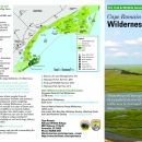
Cape Romain NWR and Francis Marion NF brochures, maps, and recreation guides for boating, hiking and other activities can be picked up at the Sewee Center and at the Refuge Headquarters. Brochures for Cape Romain NWR can also be found at Garris Landing and on Bulls Island.
Other Facilities in the Complex
Encompassing over 115,000 acres, South Carolina Lowcountry Refuges Complex is home to four national wildlife refuges located in the coastal area known as the Lowcountry, the low lands extending from the Atlantic Ocean to the western sandhills. These public lands comprise some of the most unique and biologically diverse wetland and upland ecosystems along the Atlantic Coast. , Other than Cape Romain NWR, the Complex includes Ernest F. Hollings ACE Basin NWR,one of the largest undeveloped estuarine wetland systems remaining along the U.S. Atlantic coast, Waccamaw NWR, a critically endangered longleaf pine forest ecosystem and, Santee NWR, the only known maritime sandhill community in the state.
Rules and Policies
At Cape Romain NWR, we strive to protect our natural and cultural resources and work to ensure that visitors have a safe and enjoyable visit. Please follow all rules and regulations outlined in the refuge brochure when visiting Cape Romain. You can pick up the refuge brochure at our Headquarters, Sewee Visitor and Environmental Education Center, and at the kiosks at Garris Landing and Bulls Island. Signage displaying permitted and prohibited activities are found at Garris Landing and on refuge islands. Become familiar with and follow all applicable state fishing regulations while fishing in refuge waters and, follow all federal and state laws and applications when hunting on the refuge.
All local, state and federal regulations apply on the refuge. General regulations for Cape Romain NWR include the following:
- The refuge is open during daylight hours only, from sunrise to sunset.
- Entering any area posted with area closed signs is prohibited.
- Marsh Island and White Banks Islands are closed to protect nesting birds from February 15 - September 15.
- Camping is prohibited. Camping facilities are located nearby on the Francis Marion National Forest. Call the Sewee Center at (843) 928-3368.
- Pets are not allowed on refuge islands or on the pier at Garris Landing. Pets are allowed in boats in the estuary waterways.
- Bicycles are only allowed on the service roads on Bulls Island. Riding bicycles on the beach or on designated hiking trails is prohibited.
- Fishing from or into the service area docking facilities on Bulls Island is prohibited.
Locations
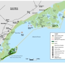
The Refuge Headquarters is located in the town of Awendaw on North Highway 17, approximately twelve miles north of the large suburban town Mount Pleasant and 14 miles south of the town of McClellanville. North of Headquarters and within walking distance is the refuge visitor center, Sewee Visitor and Environmental Education Center. The Headquarters and Center are two of three mainland sites, the third being Garris Landing, located at the end of Bulls Island Road, Awendaw. Refuge islands and salt marshes are only accessible by boat.
Directions to Refuge Headquarters
From Long Point Rd /State Rd S-10-97 & US-17 in Mount Pleasant; Drive north on US-17 N/N Hwy 17 ~12.5 miles; Headquarters is on the right.
From SC-45 & US-17 in McClellanville; Drive south on US-17 ~14 miles; Make first U-turn past Headquarters; Head north on US-17; Headquarters drive is on the right.
Directions to Sewee Visitor and Environmental Education Center
From Long Point Rd /State Rd S-10-97 & US-17 in Mount Pleasant; Drive north on US-17 N/N Hwy 17 ~12.5 mile; Sewee Center is on the right.
From SC-45 & US-17 in McClellanville; Drive south on US-17 ~14 miles; Turn left and cross US-17 onto the Sewee Center entrance drive.
GPS Coordinates: 32.97499, -79.6693
Directions to Garris Landing
From Long Point Rd/State Rd S-10-97 & US-17 in Mount Pleasant; Drive north on US-17 N/N Hwy 17 ~8.5 miles; Turn right onto Seewee Rd/State Rd S-10-584; Follow Seewee Rd to Bulls Island Rd; Turn right onto Bulls Island Rd; Drive ~ 1.5 miles; Garris Landing entrance gate is ahead.
From SC-45 & US-17 in McClellanville; Head south on US-17 S; Turn left onto Doar Rd/State Rd S-10-432; Turn right onto Seewee Rd/State Rd S-10-584; Follow Seewee Rd to Bulls Island Rd; Turn left onto Bulls Island Rd; Drive ~ 1.5 miles; Garris Landing entrance gate is ahead.
GPS Coordinates: 32.9402, -79.6581