


Visit Us

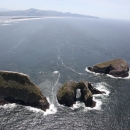
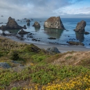
The combination of precipitous coastal cliffs and decadent old-growth forest of Cape Meares represents an exceedingly rare setting on the Oregon coast.
- HIKE the nature trails that wind through old-growth spruce/hemlock forest.
- TOUR the coast's shortest lighthouse.
- HUG the largest Sitka Spruce in Oregon - a champion tree!
- SEE Gray Whales migrating past the headland
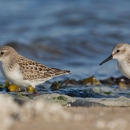
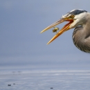
- HEAR the sounds of tens of thousands of seabird calling from their nests.
Activities
Cape Meares is a headland on the north coast of Oregon. Part of the headland is an Oregon State Park and the rest is a National Wildlife Refuge. Together our agencies manage this headland to preserve and protect its historic and natural resources.
Trails
Visitors can enjoy hikes through the headland and old-growth forest of Cape Meares National Wildlife Refuge and State Scenic Viewpoint. Four unique trails lead visitors all around the cape. From the small parking area on Cape Meares Loop, take the short trek to Oregon’s Champion Sitka Spruce tree or walk a segment of the popular Oregon Coast Trail which runs through the center of the refuge and down to the beach.
From the main parking area, hike to the unique and magnificent Octopus Tree or to Oregon’s shortest lighthouse. Interpretive panels along this headland trail offer information about the refuge and its wild inhabitants.
Big Spruce Trail
Open: Year Round
Length: 0.1 mi out and back (0.2 mi round)
Details: Trailhead located at the parking area on Cape Meares Loop, before the left-hand turn at the Cape Meares State Scenic Viewpoint and National Wildlife Refuge sign. See the interpretive panel located at the trailhead for information on the big spruce and Cape Meares. Past the panel, take a left toward the big spruce. The righthand trail will take you down to the beach. Enjoy the short walk to the big spruce through the increasingly rare old-growth forest. Easy.
Cape Meares Beach Trail (Oregon Coast Trail Segment)
Open: Year Round
Length: 1.5 mi out and back (3 mi round)
Details: Trailhead located at the parking area on Cape Meares Loop, before the left-hand turn at the Cape Meares State Scenic Viewpoint and National Wildlife Refuge sign. See the interpretive panel located at the trailhead for information about the cape. Past the panel, take a right onto the trail, which is a segment of the Oregon Coast Trail. Follow the trail through spectacular old-growth forest down to the sandy beach. Moderately difficult.
Lighthouse Trail
Open: Year Round
Length: 0.3 mi loop
Details: Begin hike on either side of the Sallie Jacobson Interpretive kiosk located on the west side of the main parking area. The trail follows the cape down to Oregon’s shortest lighthouse, past award-winning interpretive panels highlighting the wildlife of Cape Meares over spectacular viewpoints. See the Oregon Parks and Recreation Department website for information on touring the lighthouse. Paved trail with some elevation change.
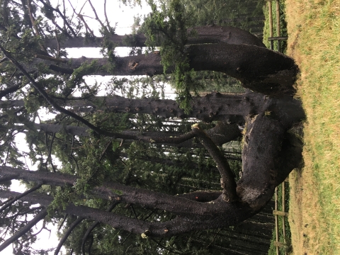
Octopus Tree Trail
Open: Year Round
Length: 0.1 mi out and back (0.2 mi round)
Details: This trail begins just past the restrooms on the east side of the main parking area. The trail winds through beautiful forest and comes to a marvelously unique Sitka Spruce tree, with a short, wide trunk and a number of limbs protruding out like an octopus’ arms. Stop and view the ocean toward the south and Three Arch Rocks National Wildlife Refuge before turning back. Easy.
Related Documents
Directions
Cape Meares is just north of the coastal village of Oceanside. From Tillamook or U.S. Highway 101 take highway 131 to the refuge. Look for the sign for Cape Meares Lighthouse.
*WARNING * Do NOT take Bayocean road to reach the wildlife refuge via car because the road is permanently closed due to landslides.
Hikers can still access the refuge from the town of Cape Meares, located north of the refuge, via nature trails.
Hours & Fees
There are no fees for this refuge.
The refuge is open year-round from sunrise to sunset.
Oregon State Parks runs tours of the lighthouse in the summer. Check to see if reservations are needed.
Weather & Tides
Weather on the coast is a mercurial thing. You can expect to experience temperatures ranging between 45 and 75 degrees; fog and high winds are common, as well as radiant sunshine. Rain is a perennial threat, so bring proper attire. If you're visiting during the winter, expect rainy conditions. In summer, you may experience sunny and dry days.
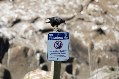
Incoming tides isolate rocks from headlands and the shore. Avoid the temptation of strolling to a nearshore rock without knowing the tides; a rising tide can strand an unwitting explorer. Climbing offshore rocks and islands, which make up Oregon Islands National Wildlife Refuge, is illegal.
Other Facilities in the Complex
Cape Meares National Wildlife Refuge is managed as one of six refuges in the Oregon Coast National Wildlife Refuge Complex. See below for the other five refuges and experience them all.
Oregon Coast National Wildlife Refuge Complex
2127 SE Marine Science Drive
Newport, OR 97365
541-867-4550
oregoncoast@fws.gov
What is a Refuge Complex?
A National Wildlife Refuge Complex is a group of two or more refuges, wildlife management areas or other refuge conservation areas that are managed from one central office. Refuges are grouped into a complex because they occur in a similar ecological region, such as a watershed or specific habitat type, and have a related purpose and management needs.
The Oregon Coast National Wildlife Refuge Complex is managed from our headquarters in Newport, Oregon. The office located at Bandon Marsh NWR serves as a south-coast field office.

Rules and Policies
The partnership at Cape Meares between the U.S. Fish and Wildlife Service and Oregon Parks and Recreation Department benefits both wildlife and people. Cape Meares is a National Wildlife Refuge adjacent to a State Park, so wildlife will always find sanctuary here, and people will always have the opportunity to observe it.
Rules and Policies of the National Wildlife Refuge and State Scenic Viewpoint may differ: visit the Cape Meares State Scenic Viewpoint website for more information.
Locations
This is the main parking area for Cape Meares State Scenic Viewpoint and National Wildlife Refuge. From the large looped parking lot, visit the observation decks, hike to the lighthouse, see the Octopus Tree, access the restrooms or picnic area.
Cape Meares is near the town of Netarts. From Tillamook, take 3rd Street/Netarts Highway to the West. Follow Netarts Highway through the town of Netarts to the refuge. Look for the sign for Cape Meares State Scenic Viewpoint.
Note: Do not attempt to drive to Cape Meares via Bayocean Road.
As of early 2015, landslide damage has closed a portion of the Cape Meares Loop Road between Cape Meares Wildlife Refuge and the town of Cape Meares accessed via Bayocean Rd. Hikers can still access the refuge from the town of Cape Meares via trails. Drivers should enter the refuge via State Road 131 through Netarts by following the signs in the town of Oceanside.