
Visit Us
Seedskadee is a bit of an oasis in a desert, sagebrush sagebrush
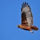
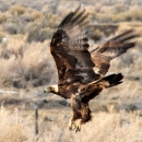
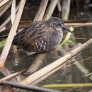
The western United States’ sagebrush country encompasses over 175 million acres of public and private lands. The sagebrush landscape provides many benefits to our rural economies and communities, and it serves as crucial habitat for a diversity of wildlife, including the iconic greater sage-grouse and over 350 other species.
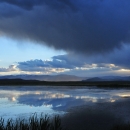
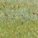
Learn more about sagebrush desert, that is. The ribbon of green that surrounds the Green River, winds through miles of generally very dry upland sagebrush steppe. At first impression, it's a big empty landscape, but with a closer look one may begin to appreciate the solitude and notice the small pieces that make up and contribute to the system and natural rhythms of the seasons. The green ribbon the Green River provides becomes a sort of wildlife super highway. Everything from our very large moose, down to tiny migrating hummingbirds or warblers utilize the river corridor as they migrate and move across the landscape. The fish in the river move to different places as the water temperature changes, signaling spawning cycles or refuge from summer heat. Many people visit the area for a variety of reasons; fishing, hunting, birding, hiking, watching wildlife, photography, or to just enjoy the solitude. We hope we can provide you with all the information needed for you to discover your reason for visiting Seedskadee.
Activities
Seedskadee Refuge provides numerous recreation opportunities to hundreds of visitors every year. People enjoy viewing the unique scenery and diverse wildlife, whether boating, driving, horseback riding, bird/wildlife watching, photographing, hiking, hunting, fishing, or taking part in historical interpretation. Regulation of recreation activities allow for public enjoyment of the Refuge while still protecting the wildlife and habitats found on the unique landscape along the Green River in SW Wyoming's high desert plains.
Trails
The Flicker Trail begins at the headquarters and follows management trails down to the Green River and cottonwood gallery past the wetlands. Total loop is around 2 miles and is a good place to see moose or various species of birds. This trail is native surface, much of the trail is a two-track road or a roughly mowed path.
Lumbard Ferry trail has interpretive information and is a 1/4 mile in length and provides universal access with a paved trail surface. Historical replica of a ferry sits at the end of the trail, which overlooks the Green River at a location that was a main crossing on the Oregon, Mormon, and California Trails.
Related Documents
Print out maps to help you navigate the refuge during your visit or pick up paper copies of most of our brochures, which include maps, from our headquarters office and public restrooms. Cell phone service on the refuge is available, but often not good enough to use navigation services or browse online resources.
Other Facilities in the Complex
Seedskadee National Wildlife Refuge is managed as part of the Central Sage Steppe Conservation Complex. A Conservation Complex is a group of two or more refuges, wildlife management areas, wetland management districts, or conservation areas that are primarily managed from a central office location. Refuges are grouped into a complex because they occur in a similar region, such as a watershed or specific habitat type, and have a related purpose and management needs. Typically, a project leader oversees the management of the refuges within the complex and refuge managers are responsible for operations at specific refuges. Support staff: administrative, law enforcement, refuge manager, biological, fire, visitor services, and maintenance, are centrally located and help with all refuges within the complex.
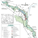
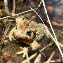
Other refuges in the Central Sage Steppe Conservation Complex include: Cokeville Meadows National Wildlife Refuge; Wyoming's portion of the Bear River Watershed Conservation Area; Pathfinder National Wildlife Refuge - near Casper; four refuges on the Laramie Plains: Bamforth National Wildlife Refuge, Hutton Lake National Wildlife Refuge, Mortenson Lake National Wildlife Refuge and the Wyoming Toad Conservation Area; and Arapaho National Wildlife Refuge near Walden in Northwestern Colorado. Administrative headquarters for the southwestern Wyoming refuges is located at Seedskadee National Wildlife Refuge, 37 miles north of Green River on Hwy 372 - 246 Seedskadee Road, PO Box 700, Green River, WY 82935; phone number 307-875-2187. Administrative headquarters for Arapaho, Pathfinder, and the Laramie Plains refuges is located at Arapaho National Wildlife Refuge, in Walden, CO phone number 970-732-8202.
Rules and Policies
In order to protect National Wildlife Refuge resources, reduce competing uses, and safeguard visitors, it is necessary to establish regulations on the use of the Refuge. Your cooperation is necessary to help us properly manage the Refuge and its wildlife.
Locations
Refuge headquarters offers restrooms and visitor information 7 days a week during daylight hours. A visitors center / environmental education building with interactive displays and observation deck are open when staff is available.
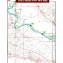
From South (Green River / Rock Springs areas)
Head west on Interstate 80, nine miles after Green River turn north on La Barge Highway 372 (Exit 83). Travel 27 miles north on La Barge Hwy 372 and after the junction with Hwy 28 take the first right. Headquarters and Visitor's Center is 2.5 miles down the gravel entrance road.
From North (La Barge / Kemmerer / Diamondville areas)
From the intersection of Hwy 189 and Hwy 372, head east on Hwy 372. After eight miles the road will come to a 4-way intersection at Fontenelle Store, turn right and travel South on Hwy 372 for 13 miles. Just before the junction with Hwy 28 turn left onto the Seedskadee Entrance Road. Travel down graveled entrance road for 2.5 miles to Refuge Headquarters and Visitor's Center.
From East (Farson / Hwy 28 / Lander areas)
Head West on Hwy 28 at intersection of Hwy 191 and Hwy 28 in Farson for 25 miles. Just after Hwy 28 crosses the Green River turn north (right) onto gravel road and travel 3 miles to Refuge Headquarters and Visitor's Center.
For a map of the Refuge, see the general brochure or on our Refuge Regulations sheet.