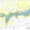
The U.S. Fish and Wildlife Service is seeking public comments on the proposed draft Compatibility Determination for utility rights-of-way to the Pines Recreation Area on Charles M. Russell National Wildlife Refuge for NorVal Electric Cooperative and Nemont Telephone Cooperative. Public comments will be accepted from July 13, 2026 to July 26, 2026. The document can be found in our Library.


Visit Us
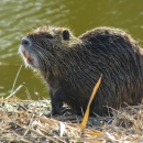
Charles M. Russell National Wildlife Refuge provides a rare opportunity to experience wild lands and wildlife in a natural setting and in nearly the same surroundings as encountered by the Lewis and Clark Expedition in 1805. Many wildlife-oriented recreational opportunities are offered at Charles M. Russell Refuge, including hunting, fishing, camping, and hiking.
At the Fort Peck Interpretive Center, a cooperative effort between the U.S. Army Corps of Engineers and the U.S. Fish and Wildlife Service, visitors can explore the wildlife of the Refuge as well as the rich history of the area, from dinosaurs to the building of the Fort Peck Dam.
Location and Contact Information
About Us
Charles M. Russell National Wildlife Refuge is managed by the U.S. Fish and Wildlife Service. The refuge is one of over 560 refuges in the National Wildlife Refuge System - a system of lands set aside to conserve wildlife and habitat for people today and generations to come. It is the second largest national wildlife refuge national wildlife refuge
A national wildlife refuge is typically a contiguous area of land and water managed by the U.S. Fish and Wildlife Service for the conservation and, where appropriate, restoration of fish, wildlife and plant resources and their habitats for the benefit of present and future generations of Americans.
Learn more about national wildlife refuge in the lower 48 states.
What We Do
The overall management goal at Charles M. Russell National Wildlife Refuge is to promote biological diversity and maintain the natural abundance of native plants and wildlife. Science is the foundation upon which conservation decisions are made. Charles M. Russell Refuge uses research, monitoring and the best-available science to inform its work to conserve fish, wildlife, plants, and their habitat.