


About Us
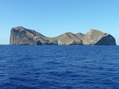
Nihoa Island
Nihoa is unlike any other Northwestern Hawaiian Island (NWHI) with its nine hundred-foot cliffs, basalt rock surface, and tiny beach. This small island is about 1-square km and is at the southeastern end of the NWHI chain.
What today seems impossible, this remote land of rugged cliffs and steep valleys housed Hawaiians up until the 13th century. Evidence of their presence includes the remains of 35 house terraces, 15 ceremonial structures, burial sites, bluff shelters (rock caves), and agricultural terraces. Many of the sites and artifacts were similar to those made on the Main Hawaiian Islands. Archaeologists say there may have been up to 175 Hawaiians living there during prehistoric times. Due to severe shortage of fresh water and other resources, the Nihoa residents probably only lived on the island for a few days or months at a time.
Nihoa has been part of several notable historical events. In 1789, Captain Douglas of the ship Iphegenia set foot on Nihoa and noted that the island was uninhabited. Queen Kaʻahumanu visited in 1822 and annexed the island as part of the Kingdom of Hawaiʻi. In 1885, Queen Liliuʻokalani and her 200-person entourage documented their adventure in journals and photos that are now kept at Bishop Museum. In 1909, Nihoa and all the other islets and reefs of the Northwestern Hawaiian Islands (except Midway) were recognized as a valuable National treasure, to be protected in perpetuity as the Hawaiian Islands Reservation. “The Reservation” was the forerunner of one of the earliest established National Wildlife Refuges in the country. A group of scientists later conducted research on Nihoa in 1923-24 as part of “the Tanager Expedition”. In 1997, native Hawaiians from the Hui Mälama I Nä Kupuna O Hawai`i Nei organization returned ancestral bones to the island that had been found there decades earlier and kept at Bishop Museum.
Nihoa’s rugged landscape may seem from a distance inhabitable but the very essence of Nihoa is life, a treasure chest of species found living nowhere else in the world. Niches in rocky outcroppings house some the most unique and varied bird, insect and plant life of all the Northwest Hawaiian islands and are reminiscent of species that once thrived in the main Hawaiian islands.
Forty terrestrial anthropods including a giant cricket and giant earwigs and two endemic landbirds, Nihoa finch and Nihoa millerbird are found only on Nihoa. Native, endangered plants include the loulu of Nihoa fan palm and the native ʻohai shrub
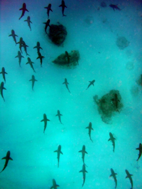
Marine life is limited to the reef system surrounding the island. In deeper waters, along the Raita Bank, sharks and jacks hover. Limu (algae), wana (sea urchin), and opihi (limpet) live in the shallow waters.
There are restrictions on who can visit Nihoa in order to protect the island’s fragile ecosystem. Approval must be given by the U.S. Fish & Wildlife Service and strict ecological is mostly granted to those doing cultural and scientific research.
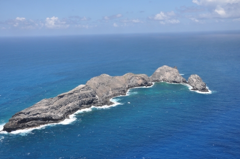
Mokumanamana (Necker Island)
About 155 miles northwest of Nihoa lies Mokumanamana, a small basalt island that is 1/6 square km or 39-1/2 acres in size.
Although the island is the second smallest of the Northwestern Hawaiian Islands, it has the second largest surrounding marine habitat. Large offshore areas include Shark Bay on the north side, West Cove and Northwest Cape as well as miles of shallow reef to the southeast.
Mokumanamana is known for its numerous religious sites and artifacts. Fifty-two sites have been found that appear to have been used mainly for worship. Since the island seems to be too small and dry for living, with poor soil for farming, archaeologists believe that the religious sites were probably used by Hawaiians, who visited from nearby Nihoa and other islands, but didn’t stay.
In 1786, Compte de La Pérouse, a French explorer, visited Mokumanamana and named it “Necker Island” after Jacques Necker, the finance minister under Louis XVI. Captain John Paty claimed the island in 1857 for the Kingdom of Hawaiʻi under King Kamehameha IV. His claim was contested until the island was annexed by Hawaiʻi’s Provisional Government in 1894.
Important archaeological and biological studies were made on the island when the Tanager Expedition visited in 1923-24. Most recently in 1997, members of the native Hawaiian organization Hui Mälama I Nä Kupuna O Hawaiʻi Nei visited Mokumanamana to rebury the ancestral human bones originally found there that had been kept at Bishop Museum.
Terrestrial (land) animal life on Mokumanamana includes the blue gray noddy, land snails and fifteen endemic (found only on that island) insects such as wolf spiders and bird ticks.
Marine life includes gray reef sharks and manta rays. Hawaiian monk seals are seen on the island’s rocky shores. At Shark Bay, there is a great abundance and diversity of sea cucumbers, sea urchins, and lobsters. Little coral life exists in the shallow areas due to run off from the heavily eroded and scoured rock surfaces of the island. Below the shallow reef are extensive deeper “shelves” that extend many miles from the island, especially to the southeast. These broad offshore areas are used for commercial fishing.
Presently, visiting Mokumanamana is permitted only for scientific, educational and cultural purposes.
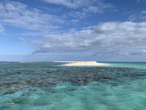
French Frigate Shoals
French Frigate Shoals is an atoll consisting of a large, crescent-shaped reef surrounding numerous small, sandy islets. While the land area is only 1/4-square kilometer, the total coral reef area of the shoals is over 744 square kilometers.
French Frigate Shoals is an atoll consisting of a large, crescent-shaped reef surrounding numerous small, sandy islets. While the land area is only 1/4-square kilometer, the total coral reef area of the shoals is over 744 square kilometers.
French Frigate Shoals is a classic atoll, formed on top of a volcano now submerged after millions of years of erosion, and surrounded by a well-developed coral reef. In the center of the atoll is a unique rock formation, a steep-sided basalt pinnacle that juts out of the water and is the last remnant of the original volcano. In 1786, two French ships under the command of Compte de La Pérouse, making one of the first visits to FFS by Westerners, discovered the rock and named it “La Pérouse Pinnacle” after their captain.
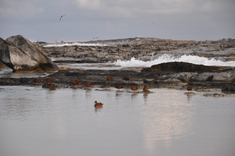
The shoals are important historically because they were used by the military during World War II. Tern Island, a part of the atoll, was formed into a runway to serve as a refueling stop for planes en route to Midway. The original seawall and building structures remain. The island is inhabited during summer months by the National Oceanic and Atmospheric Administration (NOAA) National Marine Fisheries Service (NMFS) Hawaiian monk seal and turtle camps. The U.S. Fish & Wildlife Service regularly monitors the island with periodic trips throughout the year.
French Frigate Shoals has one of the most significant reef systems in the Northwestern Hawaiian Islands. The reef supports the greatest variety of coral species including the acropora table coral, finger coral, and stony coral. There are also over 600 species of invertebrates such as sponges, coral worms, snails, lobster, crabs, shrimp clams, oysters, sea urchins, and sea stars. Many of these invertebrates are endemic (found only there) to the shoals. There are over 150 species of algae living among the reefs. They include red, green and brown algae. Other marine life are the large invertebrates such as echinoderms, crustaceans, and mollusks. One area of the reef consists almost entirely of bivalve clams. The outer reef waters support gray reef sharks, butterfly fish, and large schools of jacks and groupers.
French Frigate Shoals nutures plenty of charismatic megafauna -- the green turtles and Hawaiian monk seals. Over 90% of the Hawaiian population of threatened green turtles travel to the FFS for safe nesting. Satellite tagging of these turtles has indicated that most of them migrate to the main Hawaiian Islands to feed and then return to breed at French Frigate Shoals, while some turtles travel northwest to feed and others have traveled as far south as Johnston Atoll. The many small islets of FFS also attract the largest number of endangered Hawaiian monk seals in the NWHI. It is “their” place of refuge.
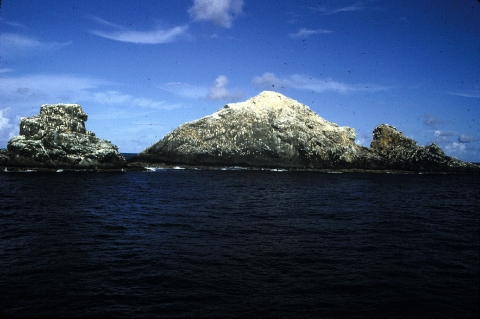
Gardner Pinnacles
When the two pinnacles of volcanic rock between French Frigate Shoals and Maro Reef come into view, mariners know that Gardner Pinnacles has been reached. This 5-acre island, with the smallest land area of any Northwestern Hawaiian Islands (NWHI), has 1,904 square kilometers of underwater shelves that extend out from the pinnacles, the most of any island or bank in the NWHI.
The pinnacles were first reported by Captain Joseph Allen of the Nantucket whaler, Maro, on June 2, 1820. He reported seeing “a new island or rock not laid down on any of our charts - it has two detached humps - we call it Gardner’s Island.”
Today, Gardner is known for its abundance of giant opihi, the endemic (found nowhere else) Hawaiian limpet. The islands’ rocky inter-tidal areas are an ideal habitat for opihi. Coral species of many varieties are distributed throughout the pinnacles’ reef system. Acropora table corals have been noted on the leeward side, while tube, stony, and soft corals have been found throughout the reef. Gardner Pinnacles’ waters hold one of the highest numbers of fish species in the NWHI, including the red lip parrotfish, the doublebar goatfish, and the reef triggerfish.
Gardner is home to seabirds, insects, and one species of plant, the succulent sea purslane (Portulaca). Scientists have observed nineteen species of seabirds, twelve of which breed on the steep cliffs, including the rare blue gray noddy. Two species of migratory shorebirds, the ruddy turnstone and golden plover often stop over to rest or feed here as commonly noted in all the NWHI.
Despite its small size and isolation, the island has a surprisingly wide array of insects. Spiders, mites, moths, centipedes, flies, beetles, isopods and earwigs, among others, have been found on Gardner. Insect researcher Gordon Nishida found what he believes are two new species of spiders on a recent expedition.
Maro Reef
Maro Reef is the largest coral reef in the Northwestern Hawaiian Islands (NWHI), with over 1500 square km (approximately 600 square miles) of reef area. Unlike the classic ring-shaped atoll, Maro is a complex maze of linear reefs that radiate out from the center like the spokes of a wheel.
Captain Allen of the whaling ship Maro was the first Westerner to discover the reef in 1820, after his discovery of Gardner Pinnacles.
Marine habitats of Maro Reef range from sandy lagoons to steep reef slopes, large coral heads, ocean pinnacles, and patch reefs. Gaps in the reef cause waves to sweep into the lagoon clouding some areas with silt and sand.
Maro Reef is very large and hard to navigate, making it difficult for scientists to study. However, scientists who have been there have seen a greater abundance and diversity of coral than most any other reef system in the NWHI chain. Many areas of the reef, particularly on the west side, have a large number of coral species, including Montiporacapitata and finger coral Porites compressa that grow abundantly on the reef slopes. Maro Reef has a large amount of the hard, pink crusty algae that grows on coral called “coralline algae” that acts like cement and holds the coral together in high surf. The reefs support numerous butterflyfish and surgeonfish species.Large ulua and omilu have been seen in the reef’s open waters, along with white-tip and grey reef sharks.
Some researchers believe that, while Maro Reef has very healthy reefs, it may be “on the verge of drowning” because the reefs are narrow, unconnected, and unprotected from storm waves. Others feel that the health of the corals suggest that Maro Reef is a complicated reef system on a large seamount, living in balance with the elements.
Laysan Island
Laysan is the second largest land mass in the Northwestern Hawaiian Islands (NWHI), about 1 mile wide and 1-1/2 miles long, shaped like a poi board.
It was formed from geologic forces pushing upward and by coral growth. It has fringing reefs, and a hypersaline (very salty) lake in the middle of the island, the only lake in the island chain.
The island’s easy access and large amount of seabirds made it a base for traders of guano (bird droppings used as fertilizer) and feather harvesters in the late 1800s and early 1900s. Although the practices were declared illegal, poachers killed hundreds of thousands of birds, causing the extinction of some species and dramatically changing the island’s ecosystem. Remnants of guano piles remain from this era. Rabbits released in the early 1900s devastated the island's vegetation.
Laysan has the largest, diverse bird colony in the NWHI, where huge populations of seabirds nest and migratory shorebirds visit. Birds found at Laysan include black-footed and Laysan albatross, Christmas and wedge-tailed shearwaters, and bristle-thighed curlews. Following the devegetation caused by rabbits, several land birds became extinct including the Laysan honeycreeper and millerbird, but two endemic (found only on Laysan) land birds remain -- the hardy Laysan finch and Laysan duck. Miraculously “the survivor list” includes fifteen species of insects endemic to Laysan.
Surrounding the lake, the beautiful encircling white sand beach is topped by dry coastal grasses as sedges grow thick near the lake’s edge. The endemic Laysan duck has developed a fascinating eating habit. It runs on mud flats while snapping at swarms of brine flies to retrieve its’ “remote island meal.” Of the 30 kinds of plants on the island, only one is endemic to Laysan.
Although the reef at Laysan is the smallest of the NWHI, it is rich. Numerous sea turtles and monk seals appear on the island. Several species of Hawaiian surgeonfish and large schools of convict tangs are in the shallow, wave-washed waters around the island. Twenty-seven species of stony coral are reported, and branching corals are common.
Although a host of introduced species changed the “original fabric” of the island’s ecology, this place has benefited from years of our ability to “malama” (take care of) the island. Efforts by the U.S. Fish and Wildlife Service have eliminated pests, rats, rabbits and weeds, and native vegetation is on the rebound. The results have become obvious as finch and duck populations are on the rise. Laysan, “the poster child for restorative island efforts” is considered one of the “crown jewels” of the NWHI.
Lisianski Island
About 20 million years ago, geologic forces raised the tip of a huge coral bank above sea level. Today, Lisianski Island is 1.4 square km, about the size of Honolulu city.
Its highest point is a sand dune that is only 40 feet above sea level. Though the island is small, the reef area to the southeast, called Neva Shoals, is huge, covering 979 square km, an area nearly the size of O‘ahu.
The earliest known sighting of Lisianski by Westerners was by accident -- in 1805, when a ship under the Russian captain, Yurii Lisianski, ran aground there. During the 1800’s, humans had a negative impact on its ecosystem. In the mid-1800s, a rescue ship picking up survivors of a shipwreck introduced mice. Later, illegal gathering of bird feathers for trade resulted in the slaughter of over one million birds on the island. This caused a public outcry which led to the creation of the Hawaiian Islands Bird Reservation by President Theodore Roosevelt in 1909.
Hawaiian monk seals and green turtles are common visitors to Lisianski's sandy, white beaches. Migratory shorebirds seen on the island include the golden plover (kolea), wandering tattler (ulili), and bristle-thighed curlew (kioea). Nearly three-fourths of the Bonin petrels nesting in Hawaiʻi make this atoll their home.
Reef fishes of the nearshore waters are abundant and diverse. Researchers have found predators near its reefs such as sharks to be very aggressive. Even Trevally jacks (ulua) will harass divers and small boats. The reefs near the island have been called "coral gardens" by scientists for their abundance of coral. Twenty-four different species of coral were found in one major survey at Lisianski.
A wide variety of algae are commonly found close to the island, and some researchers think that this results from guano (bird droppings) washing into the ocean and providing nutrients for the algae.
Pearl and Hermes Atoll
Pearl and Hermes Atoll is a true atoll that is primarily underwater and has numerous islets, seven of which are above sea level. While total land area is only 0.36 square km (80 acres), the reef area is huge, over 450 square miles (194,000 acres). The atoll is ever-changing, with islets emerging and subsiding.
The atoll was discovered by Westerners in 1822 when two English whaling ships, the Pearl and the Hermes, wrecked on the reef during a storm. In 1854, King Kamehameha III claimed the atoll. Since the atoll’s land base is small, it was largely spared the ravages of miners and feather hunters.
When Westerners first arrived, the atoll abounded with birds. Presently, about 160,000 birds from 22 species are seen. They include black-footed albatrosses, Tristram’s storm petrels, and one of two recorded Hawaiian nest sites of little terns.
The sandbar islets support coastal dry grasses, vines and herbal plants, including 16 native plant species and 12 introduced species. The plants survive because they are salt-tolerant and able to recover from frequent flooding events.
Hawaiian monk seals and sea turtles breed and feed at Pearl and Hermes, and it is a mating area for spinner dolphins. The atoll has the highest standing stock of fish and the highest number of fish species in the NWHI. These include saber squirrelfish, eels, Galapagos sharks, sandbar sharks, ulua (big jacks), angelfish, aweoweo, uhu, and numerous lobsters. Hiding between the unique reef and lagoons are very unusual invertebrate habitats.
Black-lipped pearl oysters, at one time very common, were harvested in the late 1920s to make buttons from their shells. Over-harvested, the oysters were nearly eliminated, and today only a handful remain even long after their harvesting was declared illegal in 1929.
While there has been less human impact on this atoll than others in the NWHI, problems with marine debris and the occasional shipwreck still occur. Minimizing human contact may preserve the wildlife and marine life in this extensive reef ecosystem.