

Non-Motorized Boating
Enjoy a relaxing day on water! Paddling is a great way to explore the Everglades. Non-motorized boats can be launched at any refuge boat ramp. Paddlers can explore the 5.5-mile canoe trail, the 58-mile perimeter canal, and the Refuge Interior (over 145,000 acres). Paddlers should use extra caution when traveling in the Refuge Interior off the canoe trail. The Sign Line (south of the canoe trail) is a common travel way for management airboats and extra caution is necessary to prevent accidents. Boating of any kind is not permitted in the A, B, and C Impoundments, Strazzulla, and those areas marked as being closed to the public.
Boating Regulations
Read boating regulations on our Rules and Policies page
Flag Requirement
All boats operating in the Refuge Interior, outside of the perimeter canal, must display a 10-inches by 12-inches (25 cm x 30 cm) orange flag 10-feet (3 meters) above the vessel’s waterline so that others may see you. This includes the 5.5-mile canoe trail and the entire Refuge Interior.
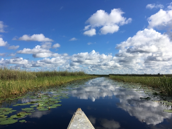
5.5-Mile Canoe Trail
This trail is accessible from the Lee Road boat ramp in Boynton Beach. This trail offers a close-up view of the Everglades ecosystem, its resident alligators, wading birds, water lilies, and other wetland species. Keep a safe distance from wildlife and give them the right of way. Paddlers follow a clearly marked, self-guided 5.5-mile loop with a rest station about halfway through. Allow 3-5 hours to complete the entire loop.
Boat Ramps
Lee Road Boat Ramp
The Lee Road Boat Ramps are located at the west end of Lee Road in Boynton Beach, FL.
Latitude/Longitude: 26.49838 -80.22204
20 Mile Bend Area Boat Ramps
The 20 Mile Bend Area boat ramps are located at the southern end of 20 Mile Bend Boat Ramp Road near Loxahatchee, FL. Latitude/Longitude: 26.67571 -80.38092
Hillsboro Area Boat Ramps
The Hillsboro Area boat ramps are located at the west end of Loxahatchee Road near Parkland, FL. Latitude/Longitude: 26.35614 -80.30005