


Visit Us
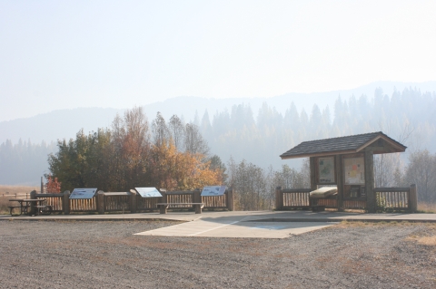
Little Pend Oreille National Wildlife Refuge is 13 miles southeast of Colville, Washington in the northeast corner of the state. The Refuge provides numerous recreation opportunities to thousands of visitors every year. Entrance to the refuge is free. Visitors will find information on the refuge’s history, wildlife, and management at the interpretive kiosks at the refuge’s entrance, public restrooms, headquarters, and trailheads. Vehicle traffic is restricted from January 1 through April 14 due to road conditions and to limit wildlife disturbance. This Refuge is managed by the Federal Government and a Washington Discover Pass is NOT required for access.
Location and Contact Information
About Us

Little Pend Oreille NWR is located about 70 miles north of Spokane, 40 miles west from the panhandle of Idaho, and 40 miles south of British Columbia, Canada. This geography means the refuge is located not only within the Columbia River Basin Ecosystem and the Okanogan Highlands Province, but also abuts the western edge of the Selkirk Mountains. With elevations ranging from 1,800 feet to 5,600 feet, Little Pend Oreille is the only mountainous, mixed-conifer forest refuge in the National Wildlife Refuge System. Six different forest zones are present, including Douglas fir, grand fir, ponderosa pine, western red cedar, western hemlock, and subalpine fir. In addition to diverse rolling pine and fir forests, refuge habitats include scattered lakes, shallow marshes, ponds and springs, plus more than 80 miles of streams. Water rushes from narrow, steep canyons with fast, rocky flows and meanders slowly through broad valleys.
Tours
To schedule a program, tour, or field trip of Little Pend Oreille National Wildlife Refuge, contact Joshua Contois at 509-559-3034, or via email at joshua_contois@fws.gov.
What We Do
Every national wildlife refuge national wildlife refuge
A national wildlife refuge is typically a contiguous area of land and water managed by the U.S. Fish and Wildlife Service for the conservation and, where appropriate, restoration of fish, wildlife and plant resources and their habitats for the benefit of present and future generations of Americans.
Learn more about national wildlife refuge was created for a special purpose. Some were created to protect migratory birds, others to protect threatened or endangered species or unique habitats, while others fulfill another special purpose. Little Pend Oreille National Wildlife Refuge was established to protect "migratory birds and other wildlife." Over the past 4 decades, the majority of work on the refuge has focused on managing the ponderosa pine habitat, which supports the Flammulated Owl, White-headed Woodpecker, and Chipping Sparrow, among other species. All activities allowed on the refuge must be evaluated to make sure each activity will not conflict with the reason the refuge was founded.
Our Organization

The mission of the U.S. Fish & Wildlife Service is "working with others to conserve, protect, and enhance fish, wildlife, plants, and their habitats for the continuing benefit of the American people."
Little Pend Oreille National Wildlife Refuge has numerous programs to effectively manage wildlife and habitat native to this ecosystem and to provide visitor services compatible to our refuge's mission and goals. Wildlife Management-related programs include fire management, forest restoration, water and wetland management, private lands conservation, invasive species invasive species
An invasive species is any plant or animal that has spread or been introduced into a new area where they are, or could, cause harm to the environment, economy, or human, animal, or plant health. Their unwelcome presence can destroy ecosystems and cost millions of dollars.
Learn more about invasive species control, inventory and monitoring, and wildlife population management. To assist us in meeting our management goals and objectives we provide environmental education and volunteering opportunities.


Get Involved

Whether you want to further conservation, learn more about nature or share your love of the outdoors, you’ve come to the right place. National wildlife refuges provide many opportunities for you to help your community by doing what you love. National wildlife refuges partner with volunteers, youth groups, landowners, neighbors and residents of urban communities to make a lasting difference. Find out how you can help make American lands healthier and communities stronger while doing something personally satisfying.