About Us
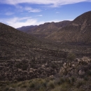
The 2,369-acre refuge lies along the international border with Mexico in southeast Arizona's Cochise County. It was established in 1982 to protect what remained of the unique wetlands of the San Bernardino ciénega, a wetland that was historically considered the largest, most extensive in the region. This large marsh serves as a migratory corridor for wildlife between the mountain ranges of Mexico to the Rocky Mountains of Arizona and New Mexico.
Our Mission
The mission of the National Wildlife Refuge System is to administer a national network of lands and waters for the conservation, management and, where appropriate, restoration of the fish, wildlife and plant resources and their habitats within the United States for the benefit of present and future generations of Americans.
Our Purpose
Every national wildlife refuge national wildlife refuge
A national wildlife refuge is typically a contiguous area of land and water managed by the U.S. Fish and Wildlife Service for the conservation and, where appropriate, restoration of fish, wildlife and plant resources and their habitats for the benefit of present and future generations of Americans.
Learn more about national wildlife refuge was created for a special purpose. Some were created to protect migratory birds, others to protect threatened or endangered species or unique habitats, while others fulfill another special purpose. Refuges are special places where wildlife comes first. All activities allowed on refuges must be evaluated to make sure each activity will not conflict with the reason the refuge was founded.
The primary role of the San Bernardino National Wildlife Refuge is the recovery of the native fish in the Río Yaqui watershed.
Our History
The dependable presence of water in this otherwise arid environment has helped support an eventful human history. Populations of Native Americans occupied pit house village sites here between 1500 and the 1400s BC.
The first Europeans likely to have passed through the region were survivors of the failed 1527 Panfilo de Narvaez expedition. Later, Fray Marcos de Niza and Friar Onorato followed the old Bavispe-Acoma trail passing through the San Bernardino Valley in 1539. They were then followed by the Francisco Vazquez de Coronado expedition, which passed through the general area in search of the fabled seven cities of Cibola during 1540-1542.
The Apache utilized this region for hunting, gathering, and raids beginning in the early 1600's. Father Eusebio Francisco Kino, accompanied by Captain Juan Mateo Manje, visited San Bernardino in 1694. To provide a base for a general offensive campaign against the Apache, the Spanish presidio established at Fronteras was temporarily relocated to the San Bernardino springs between 1775 and 1780 and extensive fortress-like buildings were constructed.
Ranching began in 1822 with the acquisition of the San Bernardino Land Grant by Lieutenant Ignacio Perez, which he purchased at a cost equal to about ninety dollars. Cattle grazing increased and was widespread for many years until the Apache drove out the ranchers.
Because of the well-known perennial springs, this area remained an important stop for travelers. When the Mormon Battalion camped at San Bernardino in 1846, the rancho had been abandoned but feral livestock were still present in the area. Boundary Commissioner John Russell Bartlett surveyed the area in 1851 and provided a good description of the San Bernardino Valley.
The San Bernardino National Wildlife Refuge was established in 1982 to protect what remained of the unique wetlands in the San Bernardino Cienega.