
Visit Us
National wildlife refuges offer us all a chance to unplug from the stresses of daily life and reconnect with our natural surroundings. Explore the great outdoors and diversity of wildlife at any one of 17 units within the Big Muddy National Fish and Wildlife Refuge. From hiking trails, observation decks, to hunting opportunities, there's plenty to enjoy.
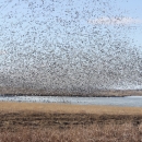
The Missouri River provides what some call the conveyor belt of wildlife viewing, creating wonderful wildlife viewing opportunities year round. You’ll likely see all sorts of migratory birds, from warblers to hawks, at various times throughout the year. You might also catch a glimpse of beavers, bobcats and other secretive wildlife traveling along the river's shoreline.
Driving Directions
Big Muddy National Fish and Wildlife Refuge headquarters and visitor contact station is located eight miles east of Boonville, Missouri. Take Interstate 70 to exit 111, (Highway 179 and 98 exit) and turn left onto 179 if coming from the west - right if coming from the east. At the junction of 179 and 98, turn left onto 98, travel half a mile and turn right onto Brady Lane. At just under a mile, continue straight ahead to the headquarters where Brady forks right.
Navigating by GPS? Enter coordinates: 38°57'17.8"N 92°36'40.6"W
Fees
There is no charge to visit.
Restrooms
Restrooms are available inside the refuge headquarters visitor contact station.
What To Do
If you have 15 minutes
- Enjoy our visitor contact station where our small interactive exhibit will introduce you to the refuge. Stretch your legs and relish the sights and sounds along the tallgrass prairie trail behind the headquarters.
If you have one hour
- Hike the Lewis and Clark Trail of Discovery. Located at our Jameson Island Unit next to the historic town of Arrow Rock, Missouri. The trail and interpretive signs provide a cultural and natural history connection. At trail end, you experience a remote riverbank along the Missouri river where eagle viewing is excellent in winter.
If you have half a day or more
- Starting at the refuge headquarters load these Missouri towns into your map-finding device: Boonville, Arrow Rock, Glasgow, Lisbon, Petersburg and Boonville. This scenic loop drives you through historic river towns and ghost river towns. Take the gravel road between the ghost towns of Lisbon and Petersburg for a remote experience of the Lisbon Bottoms unit. You will be rewarded with a spectacular drive along the Missouri River with the Jameson Island unit directly across.
Know Before You Go
When planning a trip to the refuge, it is important to wear appropriate footwear, sturdy shoes for land excursions and to dress for the weather. Consider bringing water, food, binoculars, field guides, a hat, sunscreen, insect repellent (especially for ticks during the summer), an inquisitive mind and anything else that might make your outdoor experience safer and more enjoyable.
Visitor Tips
Please note that many of the refuge units have little to no cell phone service and are subject to flooding that can happen from precipitation miles upstream. With that in mind, we recommend that you leave a hiking plan with someone else and monitor predicted river levels before venturing out on the refuge. Please contact the refuge for the latest weather information or consult the National Weather Service Advanced Hydrologic Prediction Service for the Missouri River at Boonville. If the predicted height is near low-lying rural areas along the river, do not venture out on the refuge. Please do not put yourself in a life-threatening situation due to quickly rising floodwaters.
Hunting can occur at almost any time through the year on this refuge. Although typically not a concern to non-hunting visitors, the second full week in November is the normal firearms deer season in Missouri. All visitors should consider wearing blaze orange during that week.
Activities
All refuge units are open to the public and many have at least one parking facility and informational kiosk. Some units have trails, scour lakes for fishing and all are open to hunting and undeveloped natural exploration and enjoyment. Wayfinding experience recommended if venturing off established marked trails.
Trails
Tallgrass Prairie Trail
Open season: Open year round - Not open to biking or horseback riding.
Length: 0.34 mile
Location of trail: Behind the headquarters
Surface: Grass, Gravel
Difficulty: Easy
Information: The tallgrass prairie trail begins and ends at the back door of the headquarters. Several vistas of the surrounding prairie. Overlooks into forested draws.
Lewis and Clark Trail of Discovery
Open season: Open year round - Not open to biking or horseback riding
Length: 1 mile
Location of trail: Arrow Rock, Missouri - Jameson Unit
Surface: Gravel
Difficulty: Easy
Information: This one-way trail provides an elevated hike through a floodplain forest. Views of temporary wetlands and seasonal creek. Several interpretive signs along the way. Ends along remote bank of the Missouri River.
Levee Trail
Open season: Open year round - Not open to biking or horseback riding
Length: 1 mile
Location of trail: Overton, Missouri Overton Bottoms North Unit
Surface: Natural
Difficulty: Easy
Information: This one-way trail provides an elevated hike through a floodplain forest. Views of temporary wetlands and access to two lakes. Trail ends along remote bank of the Missouri River.
Little Muddy Trail
Open season: Open year round - Not open to biking or horseback riding
Length: 3 mile loop
Location of trail: Overton, Missouri Overton Bottoms North Unit
Surface: Natural
Difficulty: Difficult
Information: Primitive hike through a floodplain forest. Subject to flooding and flood damage, often muddy. Excessive vegetation growth in summer makes trail difficult to find.
Boone’s Crossing Loop
Open season: Open year round - Not open to biking or horseback riding
Length: 1 mile
Location of trail: Chesterfield, Missouri - Boone’s Crossing Unit
Surface: Natural
Difficulty: Easy
Information: Hike through a floodplain forest and along a lake. Has access to paved Monarch Levee trail managed by the city of Chesterfield.
Bluff Overlook Trail
Open season: Open year round - Not open to biking or horseback riding
Length: 1 mile
Location of trail: Chamois, Missouri - Saint Auberts Island Unit
Surface: Natural
Difficulty: Easy
Information: Hike through upland forests and fields to a dramatic bluff overlook of the Missouri River and surrounding floodplain. Use caution at bluff edge and prepare for ticks.
Other Facilities in the Complex
Cooperative management occurs between Loess Bluffs National Wildlife Refuge, Swan Lake National Wildlife Refuge and Big Muddy National Fish and Wildlife Refuge. This cooperative management provides sharing resources between the three close and similar refuges through leadership direction from this refuge.

Rules and Policies
Big Muddy National Fish and Wildlife Refuge covers a large area along the Missouri River through the central region of the state of Missouri and has more than 20 separate units that are generally regulated under the state fish and wildlife code for hunting and fishing. While most refuge units follow statewide or regional fish and game seasons, some minor exceptions do exist, especially when a unit is in close proximity to a major metropolitan area. Please confirm specific hunting regulations at an information kiosk at the unit or call the refuge at 660-672-2800 for more information.
Big Muddy National Fish and Wildlife Refuge enforces regulations, allowing for public use and safety while protecting wildlife by following these basic guidelines. Hunting and fishing allowed on all units following general state seasons and limits, except land around the headquarters office closed to hunting. Thank you for remembering the three T’s when you visit the refuge: No trapping, no target shooting and no trashing. Unit-specific regulations may change at any time. Please call the refuge for the most current information.
Locations
Refuge headquarters includes a visitor contact station and small exhibit. The headquarters located on the Overton Bottoms North Unit.
Located just three miles upstream on the Missouri River from the confluence of the Mississippi River the Cora Island Unit is the refuges eastern most unit. It occupies 1,265 acres mostly on a remnant island of the Missouri River. Side channels constructed in 2016 restrict access on the southern end of the unit without a boat.
Deer hunting is restricted to archery only. Other game can be hunted with shotgun with non-toxic shot only. Single projectile bullet firearms not allowed.
The Boone's Crossing Unit is located in northeastern St. Louis county. The unit contains two parcels, 442 acre Johnson Island and 130 acre parcel next to the Chesterfield Athletic Complex. These two parcels are separated by a side channel of the Missouri River. The 130 acre parcel allows archery hunting only. The island allows archery deer hunting and other game restricted to archery or shotgun only with non-toxic shot no larger than BB. No bullet firearms allowed for hunting. People wanting to visit the 130 acre parcel must park in the paved parking lot of the Athletic Complex east of playing field A-3 and walk up and over the levee into the unit.
Unit in Franklin County five miles east of Herman Missouri. . Most of the south parcel is forested with cottonwoods growing since the 1993 flood. North parcel contains two scour lakes and forested area along the river. Previous farmground south of the levee in various forbs and young trees.
This unit, located in northern Osage County in east central Missouri, contains 1,124 acres and is comprised of about 700 acres of bottomland and 400 acres of upland forests and old fields. The eastern portion is only accessible from the Missouri River by boat. Private lands surrounding this unit restricts access from public roads.
Acquired in 2015 Providence Bend open to hunting and fishing under statewide regulations. Posted and open to the public in spring 2018. Levee failed and repaired after 2019 flood, Flood created scour pond available for fishing.
The Overton Bottoms South Unit is the largest unit of the refuge with over 3,900 acres. The Unit consists of floodplain forest, temporary wetlands, scour lakes and some agriculture fields.
This unit was previously the Overton Bottoms Conservation Area managed by the Missouri Department of Conservation. Now that it is managed by the US Fish and Wildlife Service the regulations have changed.
The Overton Bottoms North Unit is the most accessible unit of the refuge. This refuge unit consists of large areas of open fields with a mixture of native and exotic grasses and forbs. In addition there are large areas of dense young forests consisting primarily of cottonwood, silver maple, willow, and box elder. A narrow strip of mature cottonwood trees exists along the river. Open to hunting a fishing under statewide regulations.
The Jameson Island unit occupies a large bend of the Missouri River floodplain in Saline County, below the historic community of Arrow Rock. The unit consists of 1,871 acres of bottom land forest of cottonwood, willow, box elder, and other floodplain species. This unit is south of and across the river from the Lisbon unit. The two units are similar and combined provide 4,000 acres of public land for hunting, fishing, and exploring.
This unit occupies a large bend in the Missouri River floodplain totaling 2,013 acres and primarily consists of a young vigorous forest of cottonwood and willow. This unit is north and across the river from the Jameson Island Unit.
This unit located in northwestern Saline County and northeastern Lafayette County north of Grand Pass, Missouri. The unit consists of two parcels. The larger parcel, 745 acres, consists of open grassland areas and floodplain forests in various stages of maturity. Included in this parcel is a series of chutes or side channels of the Missouri River that form islands and restrict access without a boat.
The Baltimore Bottom Unit is located in Lafayette County approximately 3 miles west of Waverly, Missouri. The habitat of this unit consists of large open areas gradually reverting to wet prairie and floodplain forest.
The Cambridge Bend Unit of the refuge is in Saline and Chariton counties, just north of Glasgow, Missouri. The 300 acre western parcel acquired in 2012. The eastern parcel added in 2017. All standard refuge regulations apply. Both parcels of the Cambridge Bend unit only accessible to the public from the Missouri River by boat.
The Jackass Bend Unit is located in extreme southwestern Ray County and northeastern Jackson County. This unit, three miles west of Orrick off of Missouri Highway 210, consists of approximately 861 acres lying almost entirely within an old oxbow of the river.
Schmitt Unit located in eastern Chariton County near the town of Marceline. The 310 acre unit is bisected by East Yellow Creek. The unit contains wetlands, upland fields and bottomland forests habitats. The unit is open to hunting and fishing under statewide regulation. Non-toxic shot is required.
The West St. Clair unit located in St. Clair county and contains 250 acres. Area open to walk in hunting under statewide regulations.
The Moresi Unit added to the Refuge in 2016. The unit contains two parcels totaling 415 acres in Cedar and St. Clair counties. Unit open for hunting and fishing under statewide regulations. Both parcels along the Sac River with access to river by walk in only.
Located in Bates county the Panther Creek Unit contains 223 acres. The area is mostly forested with a small wetland north and east of the junction of Highway B and SE 7586 road. Area open to hunting and fishing under statewide regulations.
Howard Bend Unit is located in Maryland Heights, Missouri. To access the unit, proceed down John Pellet Court. The gates on this road should be open. At approximately 3/4 a mile you will reach a large gravel parking lot at the base of a levee. Park in the open gravel areas and walk over the levee into the unit below the levee. Only hand carts are allowed. No ATV's, bikes, or other mechanized vehicles. Additional information at information kiosk on the east side of the parking lot. Because this public hunting area is within the Maryland Heights city limits, all hunting must follow city ordinances which requires an annual permit from Chief of Police prior to hunting. Contact 314-298-8706 (Firearm Discharge Permit) For further details click this link . Then click on the question: Does the City of Maryland Heights allow hunting?
The Grand River Bend only accessible by boat on the Missouri River. At approximately 268 acres the unit consists of floodplain forest and old crop fields. The closest boat access to reach this unit is the Brunswick Access on the Grand River. All refuge regulations apply.
Bryan Island is a large island on the Missouri River northwest of St. Charles, Missouri. The Refuge acquired approximately 650 acres of the island. Posted with refuge signs in October 2023 the unit is open to public use. The only public access to the island is by boat from the Missouri River. The nearest public boat access approximately a mile and a half upstream at the Blanchette Public Access in the city of St. Charles. Hunting is allowed and state and federal seasons apply. No special restrictions at this time.
De Witt Bend contains approximately 468 acres of bottomland forest. There are few seasonal wetlands in an old side channel of the Missouri River and a more permanent scour pond on the southern end of the unit. The unit is available for hunting but only accessible from the Missouri River at this time. The nearest public boat access to reach this unit located in Miami, Missouri approximately 5.5 miles downstream of the unit. Click here for map of access.