|
|
Guide Use Area Maps |
The U.S. Fish & Wildlife Service - Alaska Region administers a permitting program for commercial guiding and outfitting (hunting and fishing) operations. Permits are issued for specific geographic regions, referred to as Guide Use Areas.
These geoPDF maps have latitude and longitude information embedded in them. You can therefore use these maps on your GPS-capable phone or tablet for field mapping and navigation. Refer to the GeoPDF Map Portal for more information about using these maps on your phone or tablet.
The primary source for obtaining Guide Use Area maps is via the USFWS Region 7 Land Mapper. Follow the steps below to select and download maps.
1) Open the USFWS Region 7 Land Mapper in a web browser.
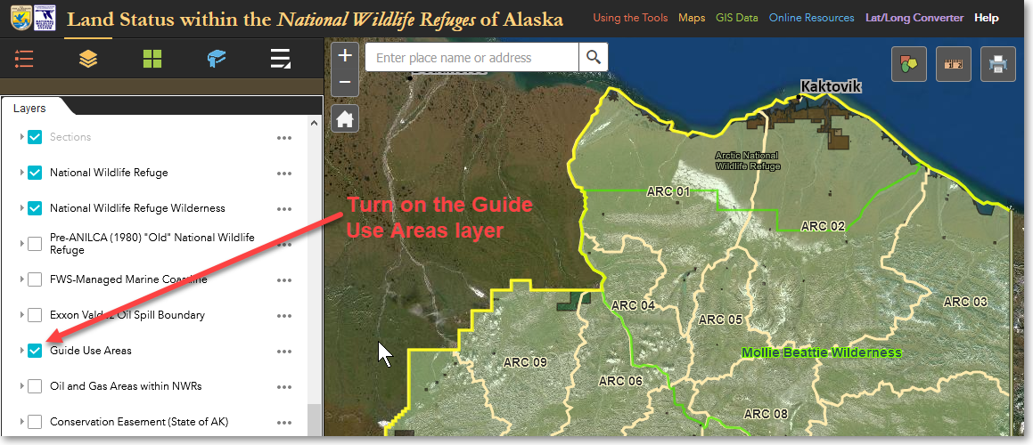
2) In the Layers list, scroll down to Guide Use Areas and click to put a check mark next to it. This makes the Guide Use Areas visible on the map.
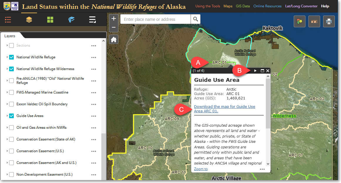
3) In the map area, click on the desired Guide Use Area (A). In the pop-up window, click the right-pointing arrow to advance to the Guide Use Area page (B) and then click on the download link (C).
Alternatively, If you prefer, you can download Guide Use Area maps for the Alaska refuges using the links below.
|
Alaska Maritime |
Alaska Peninsula |
Arctic |
Becharof |
Innoko |
Izembek |
Kanuti |
Kenai |
|
|
|||||||
|
|
|||||||
|
|
|
|
|||||
|
|
|
|
|
|
|||
|
|
|
|
|
|
|||
|
|
|
|
|
|
|
||
|
|
|
|
|
|
|
||
|
|
|
|
|
|
|
||
|
|
|
|
|
|
|
||
|
|
|
|
|
|
|
||
|
|
|
|
|
|
|
||
|
|
|
|
|
|
|
||
|
|
|
|
|
|
|
||
|
|
|
|
|
|
|
||
|
|
|
|
|
|
|
||
|
|
|
|
|
|
|
|
|
|
|
|
|
|
|
|
|
|
|
Kodiak |
Koyukuk |
Nowitna |
Selawik |
Tetlin |
Togiak |
Yukon Delta |
Yukon Flats |
|
|
|||||||
|
|
|
|
|||||
|
|
|
|
|
|
|||
|
|
|
|
|
|
|
||
|
|
|
|
|
|
|
|
|
|
|
|
|
|
|
|
|
|
|
|
|
|
|
|
|
|
|
|
|
|
|
|
|
|
|
|
|
|
|
|
|
|
|
|
|
|
|
|
|
|
|
|
|
|
|
|
|
|
|
|
|
|
|
|
|
|
|
|
|
|
|
|
|
|
|
|
|
|
|
|
|
|
|
|
|
|
|
|
|
|
|
|
|
|
|
|
|
|
|
|
|
|
|
|
|
|
|
|
|
|
|
|
|
|
|
|
|
|
|
|
|
|
|
|
|
|
|
|
|
|
|
|
|
|
|
|
|
|
|
|
|
|
|
|
|
|
|
|
|
|
|
|
|
|
|
|
|
|
|
|
|
|
|
|
|
|
|
|
|
|
|
|
|
|
|
|
|
|
|
The Region 7 Land Mapper was developed, and is maintained by, the U.S. Fish & Wildlife Service, Region 7, Division of Realty. Questions, comments,and suggestions should be directed to [email protected]
This page was last updated: Thursday, March 13, 2025