


Trails
Trails
On the refuge over 20 miles of trail may be explored. Some trails are open to biking and horses. Others are only available to pedestrians on foot.Please see below for maps.
The Viewing Area consists of a hard compact gravel surface that features a view of Merganser Pond. Several viewing scopes are available for use.
Trail Length (mi)
0.11
Trail Difficulty
Easy
Trail Activities
Suitability
Dog friendly
Kid friendly
Wheelchair friendly
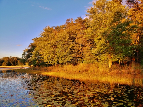
Travels along the edge of Cash Lake, the largest impoundment at Patuxent Research Refuge. This trail offers many opportunities to view the lake and its waterfowl, as well as a beaver lodge and evidence of their activity. There is also a seasonal fishing program at Cash Lake, with fishing by permit from the accessible pier and along parts of the shoreline. Information and permits are available at the information desk. Parts of Cash Lake trail beyond the fishing pier may be closed seasonally during wet conditions and to avoid disturbance of nesting waterfowl.Location: South TractStatus: Open
Trail Length (mi)
1.50
Trail Difficulty
Easy
Estimated Time
1 Hour
Route Type
Loop
Trail Activities
Suitability
Dog friendly
Kid friendly
Begins at the intersection of Valley and Laurel Trails, and crosses the exit road before ending at the edge of the Visitor Center parking lot. This wooded trail in a pine and hardwood forest travels through an old experimental tree cutting area and follows an old fire road.Location: South TractClosures: This trail closes November 28th through January.
Trail Length (mi)
0.95
Trail Difficulty
Easy
Route Type
Point to point
Trail Activities
Suitability
Dog friendly
Kid friendly
This trail traverses through second growth hardwood forest providing a glimpse of life beneath the canopy. The careful observer may find forest dwelling butterflies, song birds, and box turtles. In the autumn, the beech trees turn a brilliant gold while the maples take on a reddish hue. Any season is a perfect time to take a quiet walk along this secluded trail. Location: North Tract. Status: Open.
Trail Length (mi)
2.07
Trail Difficulty
Moderate
Estimated Time
1 Hour
Route Type
Lollipop
Trail Activities
Suitability
Dog friendly
Kid friendly
This woodland trail was named for the many Mountain Laurels found along the trail. Visitors have the opportunity to see woodland songbirds, mammals (esp. deer) and evidence of their habitat use in this mid-successional forest. This trail is dedicated to Chandler S. Robbins, one of the researchers here at Patuxent Research Center who has spent over 50 years studying migratory birds and effects of habitat fragmentation on bird populations. Visitors can continue along Valley Trail and return to Goose Pond via Cash Lake Trail.Location: South TractStatus: Open
Trail Length (mi)
0.35
Trail Difficulty
Easy
Estimated Time
15 Minutes
Route Type
Point to point
Trail Activities
Suitability
Dog friendly
Kid friendly
It is most spectacular in the spring when beautiful showy wildflowers, including Virginia blue bells, spring beauty, and Jack-in-the-pulpit carpet the forest floor.Location: North TractStatus: This trail is temporarily closed and scheduled to reopen in 2022.
Trail Length (mi)
0.35
Trail Difficulty
Easy
Route Type
Lollipop
Trail Activities
Suitability
Dog friendly
Kid friendly
This trail is paved and fully accessible. It leaves the visitor center gallery door and offers views of both Lake Redington and Cash Lake. Plantings inside the loop offer a demonstration of the PEPCO power line right-of-way management program, meadow management, and a mitigation wetland. This trail also provides access to the other trails.Location: South Tract
Trail Length (mi)
0.29
Trail Difficulty
Easy
Estimated Time
10 Minutes
Route Type
Loop
Trail Activities
Suitability
Dog friendly
Kid friendly
Wheelchair friendly
This short foot path climbs to one of the heights points on the refuge before descending to a creek bed. The trail also crosses into a young pine groove. Location: North TractStatus: Open
Trail Length (mi)
0.44
Trail Difficulty
Easy
Estimated Time
20 Minutes
Route Type
Loop
Trail Activities
Suitability
Dog friendly
Kid friendly
This trail provides access for those fishing at New Marsh.Location: North TractStatus: This trail is in an area that periodically closes. Confirm its status at the Visitor Information Station.
Trail Length (mi)
0.07
Trail Difficulty
Easy
Route Type
Point to point
Trail Activities
Located on an abandoned roadway, this trail connects Wildlife Way with with the St. Peter’s Church Cemetery. This cemetery stands as a reminder of the families of farmers who once called this area home.Location: North TractStatus: Open
Trail Length (mi)
0.53
Trail Difficulty
Easy
Estimated Time
20 Minutes
Route Type
Point to point
Trail Activities
Suitability
Dog friendly
Kid friendly
Connects Cash Lake and Laurel Trails, and follows a gully up a slight grade next to a woodland valley. Along this trail, visitors can see features of a predominantly oak and beech hardwood forest.Location: South TractStatus: Open
Trail Length (mi)
0.48
Trail Difficulty
Moderate
Estimated Time
20 Minutes
Route Type
Point to point
Trail Activities
Suitability
Dog friendly
Kid friendly
This former gun range has been cleaned of contaminants and replanted with pine trees. The trail is named for the seasonal pools that form in this area's low-lying areas. Several species of amphibian and plants thrive in these niche environments. The word "vernal" comes from the Latin word "ver" meaning spring.Location: North TractStatus: Open
Trail Length (mi)
0.28
Trail Difficulty
Easy
Estimated Time
20 Minutes
Route Type
System
Trail Activities
Suitability
Dog friendly
Kid friendly