Introduction
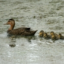
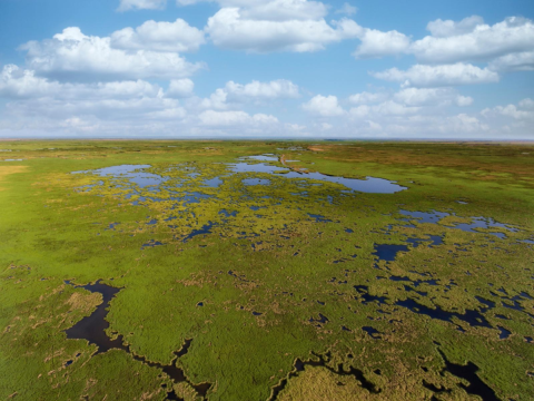
Since the 1930s, wetlands along the Gulf Coast region of the U.S. have experienced negative impacts due to sea-level rise, urbanization, increased wetland salinity, tropical storm damage, and reduced fresh-water inflows. Climate change is expected to further exacerbate these impacts on coastal wetland systems. As these habitats decline, so too do the many species that depend upon them. As one example, the population of Western Gulf Coast mottled duck (Anas fulvigula) has declined since the mid-1990s (U.S. Fish and Wildlife Service, 2011, Haukos, 2015, Rigby & Haukos, 2014). Because the mottled duck is non-migratory, it depends on coastal wetlands to satisfy all of its life requirements. Because of this dependence, mottled ducks are considered an indicator species for coastal wetland system habitat quality (Stutzenbaker, 1988; Bielefeld et al., 2010). Urbanization and sea-level rise constitute the two main threats to mottled duck habitat (Moon et al., 2021).
It is important to understand current and future conditions of coastal wetland habitat in order to plan and implement effective conservation management actions as sea-level rise and human population growth are expected to continue. Until recently, natural resource managers have lacked the analytical tools to project future habitat conditions impeding strategic conservation actions and use of adaptive management. Focusing on the mottled duck, researchers from the U.S. Fish and Wildlife Service, U.S. Geological Survey, Texas Parks and Wildlife, Ducks Unlimited, Delta Waterfowl Association, Louisiana State University and Texas A&M University-Kingsville used location data and projected future availability and quality of habitat through 2100 along the Louisiana and Texas coast. Completing this work with researchers from across multiple organizations and agencies in Texas and Louisiana provided a unique opportunity to incorporate insights and perspectives across geographies.
Key Issues Addressed
Researchers and managers have lacked region-wide data on current mottled duck habitat selection and use at key life-stages, limiting their ability to develop appropriate current and future strategies for protection of mottled duck habitat.
Additionally, limited knowledge about the impacts of sea-level rise and urbanization on future habitat conditions existed. As sea levels rise and human population increases, natural resource managers will need sufficient information on the future availability and quality of coastal wetland habitat such as region specific sea-level rise and population growth predictions.
Project Goals
- Identify current habitat selected by mottled duck utilizing telemetry data to determine breeding and brooding habitat use
- Predict mottled duck habitat that will be gained or lost from sea-level rise within coastal wetlands of Texas and Louisiana using the SLAMM model
- Leverage knowledge shared across multiple organizations, agencies and universities in Texas and Louisiana to incorporate unique insights and perspectives across geographies into model development
- Project land use effects and habitat change of future urban and suburban development on mottled duck habitat in addition to land-change and habitat change
- Provide information on future changes to mottled duck habitat based on sea-level rise and urbanization to allow resource managers to more effectively prioritize conservation actions
Project Highlights
- Mottled Duck Habitat Selection: Researchers found that mottled duck primarily select areas with freshwater and irregularly flooded marshes. Rice production in coastal Louisiana and Texas comprised an important segment of mottled duck habitat providing stable freshwater sources, feeding areas, and important resting (loafing) habitats. However, these agricultural lands are sensitive to wider-ranging economic market forces and cannot be consistently relied on for mottled duck habitat.
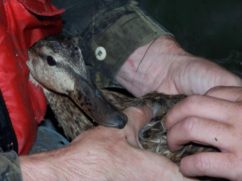
- Predicting Future Habitat: Researchers used location data collected from radio-marked mottled duck hens from 2006 to 2011 to create an ensemble model (composed of three models: a generalized linear mixed-effects model (GLMM), gradient boosted machine (GBM), and a random forest model of habitat selection for 2010. Next, they projected future habitat states using models of sea-level rise (SLAMM model) and human development (SLEUTH model). By combining future predictions with the ensemble model, they predicted future habitat for mottled duck in 20-year time blocks from 2020 through 2100.
- Coastal Marsh Habitat Reduction: Sea-level rise models predicted reductions in coastal marsh habitats, and the ensemble model predicted corresponding declines in overall habitat quantity and quality for mottled duck. Spatial predictions of future habitat for mottled duck suggested the largest rate of habitat loss is predicted within the Chenier Plain of Louisiana at 71%. In addition to rising sea-level predictions, the urbanization model predicted a 72% increase in the amount of developed land in the larger research area by 2100. However, because most of this urbanization is not expected to impact mottled duck habitat directly, the biggest habitat loss predictions came from sea-level rise.
- Research Result Application: Researchers are using the results to inform the Aransas and Big Boggy National Wildlife Refuge Land Protection Plans that are currently in development. Results are also helping to guide sampling efforts for the ongoing NOAA Firebird Research Project that is assessing how fire management may be impacting mottled duck abundance and distribution along the Gulf of Mexico.
Lessons Learned
The SLAMM proved to be useful for modeling projections across a wide geographic range, serving as a reasonable first step to engage in proactive conservation planning of coastal marsh habitats. However, modelers need to continually update these projections as more information becomes available in order to effectively re-evaluate these complex systems and engage in adaptive management.
Successful development of the products required a technical team of mottled duck experts across agencies and organizations in Texas and Louisiana. While co-development took longer due to the level of coordination required, it was worth the time investment because diverse team members provided insight into differences across geographies and perspectives among end-user groups and ultimately helped build a stronger product.
A foundational understanding of GIS datasets was essential for project success. The research team had to proceed carefully when using large land classifications across multiple states. They ensured accuracy by critically analyzing datasets to look for discrepancies in projections, comparing map classifications across states, and engaging with partners on-the-ground to ground-truth and correct datasets when needed.
Additional research on mottled duck ecology in this region, particularly in southeastern Louisiana and south Texas, could help researchers and natural resource managers better understand current and future habitat conditions and inform range-wide conservation efforts. Of particular interest are investigations of the effects of land cover and land management on nesting and brooding ecology of mottled duck. In addition, although the range of Western Gulf Coast mottled duck extends from northern Mexico to Alabama, this research effort utilized data from only Louisiana and Texas; similar research within the mottled duck’s range outside of these areas would be beneficial.
Next Steps
- Conduct additional research on mottled duck ecology in the region, particularly in southeastern Louisiana and South Texas to better understand current and future habitat conditions and inform range-wide conservation efforts
- Update coastal wetland habitat projections as more information becomes available
- Continue sharing and communicating research findings with managers to improve conservation of coastal wetlands along the Gulf Coast region
Funding Partners
- U.S. Fish and Wildlife Service through the Gulf Coast Joint Venture
- U.S. Fish and Wildlife National Wildlife Refuge System and Migratory Bird Program
- Louisiana Department of Wildlife and Fisheries
- Texas Parks and Wildlife Department
- Delta Waterfowl Foundation
- Arthur Temple College of Forestry and Agriculture at Stephen F. Austin State University
- Texas Tech University
- Texas A&M University-Kingsville
- Louisiana State University
- U.S. Geological Survey Kansas Cooperative Fish and Wildlife Research Unit at Kansas State University
Resources
- Ducks, cranes, and grains, oh my! StoryMap (requires an ArcGIS Online account)
- Moon, J. A., et al. (2021). Projected impact of sea-level rise and urbanization on mottled duck (Anas fulvigula) habitat along the Gulf Coast of Louisiana and Texas through 2100. Ecological Indicators, 132, 108276. https://doi.org/10.1016/j.ecolind.2021.108276
- Moon, J.A., et al. (2021). USFWS data release. https://doi.org/10.7944/P9LZLHXM
- Haukos, D. A. (2015). Survival and recovery rates of mottled ducks banded in Texas and Louisiana. Southeastern Association of Fish and Wildlife Agencies,2, 214220. https://pubs.er.usgs.gov/publication/70177819
- Rigby, E. (2014). A Matrix Population Model for Mottled Ducks (Anas fulvigula) of the Western Gulf Coast. Southeastern Naturalist, 13. https://doi.org/10.1656/058.013.s505
- Gulf Coast Joint Venture Mottled Duck Conservation Plan
Contacts
- Sarah Lehnen, U.S. Fish and Wildlife Service: sarah_lehnen@fws.gov
- Jena Moon, U.S. Fish and Wildlife Service: jena_moon@fws.gov
CART Lead Author
- Karlee Jewell, Conservation Biologist, U.S. Fish and Wildlife Service: karlee_jewell@fws.gov
Suggested Citation
Jewell, K., D. (2023). “Habitat Along the Gulf Coast of Louisiana and Texas: Sea-Level Rise, Urbanization, and Mottled Ducks (Anas fulvigula)” CART. Retrieved from https://www.fws.gov/project/case-study-conservation-and-adaptation-resources-toolbox.